
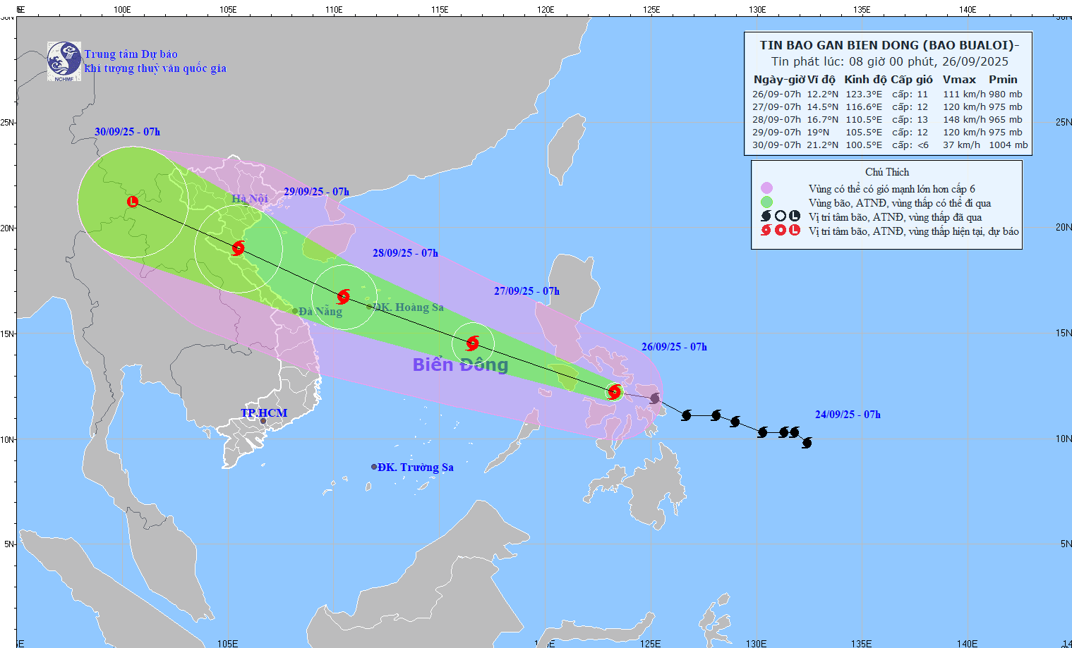
Accordingly, at 7:00 a.m. on September 26, the center of the storm was at about 12.2 degrees North latitude; 123.3 degrees East longitude, in the central region of the Philippines. The strongest wind near the center of the storm was level 11 (103-117 km/h), gusting to level 14. Moving in the West Northwest direction at a speed of about 30 km/h.
Forecast, by 7am on September 27, the center of the storm is at about 14.5 degrees North latitude; 116.6 degrees East longitude with the strongest wind level 11-12, gusting to level 15. Moving in the West Northwest direction at a speed of 30-35km/h, moving into the East Sea and tending to strengthen. The affected area is the East of the North and the middle of the East Sea. Natural disaster risk level 3.
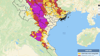
As of September 28, the storm is located at about 16.7 degrees North latitude; 110 degrees East longitude with strong winds of level 13, gusts of level 16; moving in the West Northwest direction at a speed of about 30 km/h, with the possibility of continuing to strengthen. The affected areas are the North and Central East Sea (including Hoang Sa special zone), the sea area from South Quang Tri to Quang Ngai . Natural disaster risk level 3.
As of 7:00 a.m. on September 29, the storm was located at approximately 19 degrees North latitude; 105 degrees East longitude with strong winds of level 12, gusts of level 15; moving in the West Northwest direction at a speed of approximately 25 km/h. The affected areas are the West of the North and Central East Sea (including Hoang Sa special zone), the South of Bac Bo Gulf, the sea area from South Quang Tri to Quang Ngai. Natural disaster risk level 3.
From the next 72 to 120 hours, the storm continues to move rapidly in the West Northwest direction, about 25 km/h per hour, gradually weakening in intensity.
Due to the impact of the storm, from the afternoon of September 26, the sea area east of the North and central East Sea had strong winds of level 6-7, then increased to level 8-9, the area near the storm's center had winds of level 10-12, gusts of level 15, waves 5-7m high, and rough seas.
Vessels operating in the above mentioned dangerous areas are susceptible to the impact of storms, whirlwinds, strong winds and large waves.
Source: https://baotintuc.vn/xa-hoi/bao-bualoi-di-chuyen-nhanh-huong-vaobien-dong-20250926084702963.htm


![[Photo] National Assembly Chairman Tran Thanh Man chairs the 8th Conference of full-time National Assembly deputies](https://vphoto.vietnam.vn/thumb/1200x675/vietnam/resource/IMAGE/2025/9/29/2c21459bc38d44ffaacd679ab9a0477c)
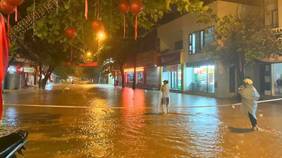
![[Photo] Many streets in Hanoi were flooded due to the effects of storm Bualoi](https://vphoto.vietnam.vn/thumb/1200x675/vietnam/resource/IMAGE/2025/9/29/18b658aa0fa2495c927ade4bbe0096df)
![[Photo] General Secretary To Lam attends the ceremony to celebrate the 80th anniversary of the post and telecommunications sector and the 66th anniversary of the science and technology sector.](https://vphoto.vietnam.vn/thumb/1200x675/vietnam/resource/IMAGE/2025/9/29/8e86b39b8fe44121a2b14a031f4cef46)
![[Photo] General Secretary To Lam receives US Ambassador to Vietnam Marc Knapper](https://vphoto.vietnam.vn/thumb/1200x675/vietnam/resource/IMAGE/2025/9/29/c8fd0761aa184da7814aee57d87c49b3)


Comment (0)