
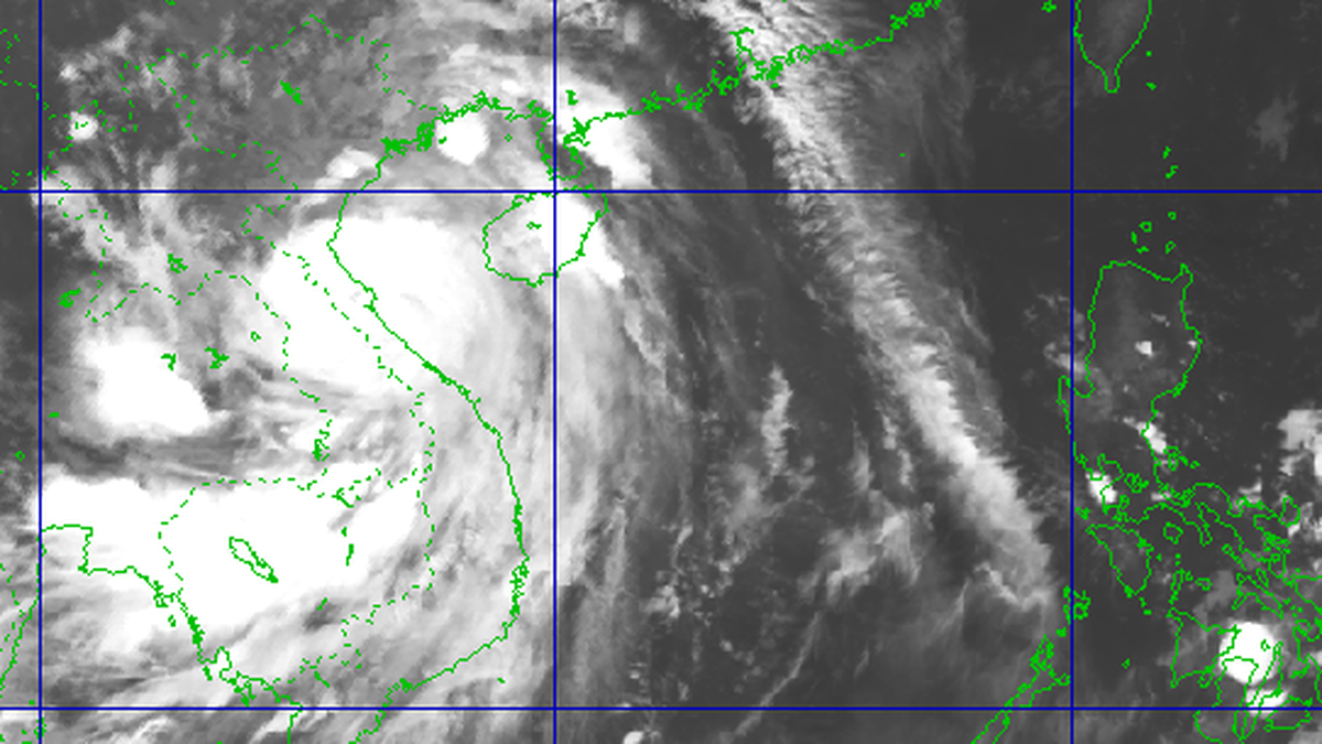
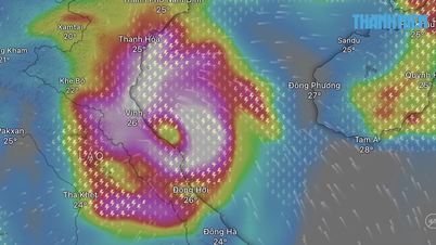
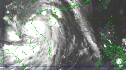
According to the National Center for Hydro-Meteorological Forecasting, at 4:00 a.m. on September 27, the center of storm No. 10 (Bualoi) was at about 14.0 degrees North latitude; 116.6 degrees East longitude, about 580km East Southeast of Hoang Sa special zone. The strongest wind near the center of the storm was level 11-12 (103-133km/h), gusting to level 15. Moving in the West Northwest direction at a speed of 35-40km/h.
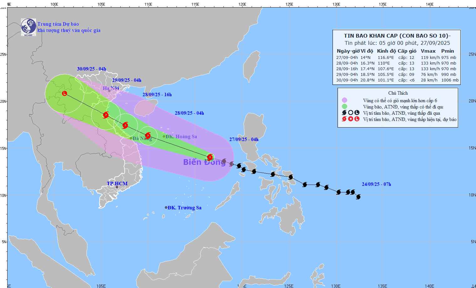
Storm forecast (next 24-72 hours): At 4am on September 28, the storm will be at 16.3°N - 110.0°E, in the sea west of Hoang Sa special zone, about 180km east of Da Nang . The storm will move west-northwest at 30-35km/h, with the potential to intensify to level 12-13, gusting to level 16.
Disaster risk level: Level 3. Affected areas: North and Central East Sea (including Hoang Sa); sea area from Ha Tinh to Quang Ngai.
At 4:00 p.m. on September 28, the storm was located at 17.4°N - 107.6°E, on the sea from Ha Tinh - Thua Thien Hue, about 160km East Southeast of North Quang Tri . The storm moved in the West Northwest direction, at a speed of about 25km/h, level 12-13 intensity, gusting to level 16.
Disaster risk level: Level 3. Affected areas: Northwest sea area of the East Sea (including Hoang Sa), Northwest central East Sea; from Thanh Hoa to Quang Ngai (Hon Ngu, Con Co, Ly Son) and Northern Gulf of Tonkin (Bach Long Vy, Van Don, Co To, Cat Hai, Hon Dau); mainland from Ninh Binh to Thua Thien Hue.
At 4:00 a.m. on September 29, the storm was located at 18.5°N - 105.5°E, on land from Nghe An to Northern Quang Tri. The storm moved in a West Northwest direction, at a speed of 20-25km/h, with a level 8-9 intensity, gusting to level 11.
Disaster risk level: Level 3. Areas affected include the Northwestern part of the East Sea (including Hoang Sa), from Thanh Hoa to Quang Ngai (Hon Ngu, Con Co, Ly Son), Northern Gulf of Tonkin (Bach Long Vy, Van Don, Co To, Cat Hai, Hon Dau); mainland from Ninh Binh to Thua Thien Hue.
At 4:00 a.m. on September 30, the storm was located at 20.8°N - 101.1°E, in the Upper Laos region. The storm moved in a West-Northwest direction, 20-25km/h, weakening into a low pressure area, with an intensity below level 6. Disaster risk level: Level 3. The affected area is the sea from Thanh Hoa to North Quang Tri (Hon Ngu, Con Co) and North Bac Bo Gulf (Bach Long Vy, Van Don, Co To, Cat Hai, Hon Dau); the mainland from Ninh Binh to North Quang Tri.
Storm No. 10 is forecast to affect the North and Central East Sea (including Hoang Sa), with winds of level 8-9, near the storm center 10-13, gusts of 16; waves of 6.0-10.0m; rough seas.
From the evening of September 27, Thanh Hoa - Quang Ngai sea area (Hon Ngu, Con Co, Ly Son): wind increased to 6-7, gusts 8-9; near the morning of September 28 increased to 8-9, near the storm center 10-13, gusts 16; waves 5.0-7.0m; rough sea.
From early morning of September 28, Northern Gulf of Tonkin (Bach Long Vy, Van Don, Co To, Cat Hai, Hon Dau): wind increases to 6-7, then strong 8-9, gust 11; waves 3.0-5.0m; very rough seas.
Storm surge: 1.0-2.0m along the coast from Ninh Binh - Ha Tinh, 1.5-2.0m in Thanh Hoa - Nghe An; risk of flooding dykes, coastal roads, destroying aquaculture.
Forecast of impacts on land, from the afternoon of September 28, storm No. 10 will affect Thanh Hoa - Northern Quang Tri with winds of 6-7, increasing to 8-9, near the storm center 10-12, gusts of 14 (dangerous, can cause trees, electric poles, houses to fall); Quang Ninh - Ninh Binh and Southern Quang Tri - Thua Thien Hue: winds of 6-7, gusts of 8-9.
The storm caused heavy rain from September 28-30 in the North and Thanh Hoa - Hue: 100-300mm, locally >400mm; in the Northern Delta and Thanh Hoa - Ha Tinh: 200-400mm, locally >600mm.
Source: https://baolaocai.vn/bao-so-10-bualoi-dang-di-chuyen-gan-gap-doi-toc-do-trung-binh-post883008.html
![[Photo] High-ranking delegation of the Russian State Duma visits President Ho Chi Minh's Mausoleum](https://vphoto.vietnam.vn/thumb/1200x675/vietnam/resource/IMAGE/2025/9/28/c6dfd505d79b460a93752e48882e8f7e)

![[Photo] Joy on the new Phong Chau bridge](https://vphoto.vietnam.vn/thumb/1200x675/vietnam/resource/IMAGE/2025/9/28/b00322b29c8043fbb8b6844fdd6c78ea)
![[Photo] The 4th meeting of the Inter-Parliamentary Cooperation Committee between the National Assembly of Vietnam and the State Duma of Russia](https://vphoto.vietnam.vn/thumb/1200x675/vietnam/resource/IMAGE/2025/9/28/9f9e84a38675449aa9c08b391e153183)


Comment (0)