
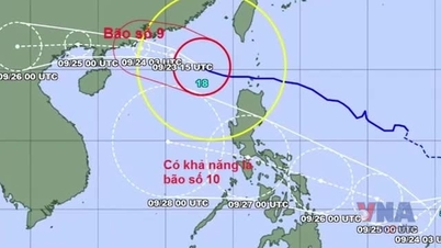
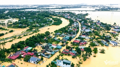
Specifically, at 4:00 a.m. on September 7, the storm center was at about 18.9 degrees North latitude - 114.8 degrees East longitude, in the northern part of the East Sea. The strongest wind near the storm center was level 8-9 (62-88 km/h), gusting to level 11. The storm moved in a West Northwest direction at a speed of 10 km/h.
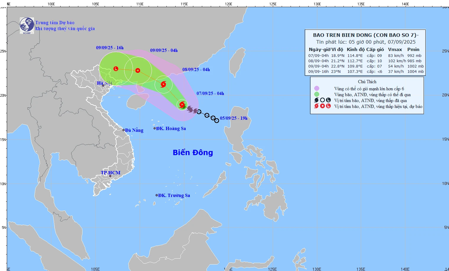
Map of forecast path and intensity of storm No. 7 issued at 5:00 a.m. on September 7, 2025.
Forecast until 44:00 on September 8, the center of the storm is at about 21.2 degrees North latitude - 112.7 degrees East longitude, in the sea area south of Guangdong province (China). Intensity level 10, gust level 13. Warning level 3 in the sea area north of the East Sea.
At 4:00 a.m. on September 9, the storm center was at about 22.8 degrees North latitude - 109.8 degrees East longitude, on the mainland of Guangdong province (China). Intensity level 6-7, gust level 9. Risk warning level 3 in the northwest sea of the East Sea.
At 4 p.m. on September 9, the storm's center was at about 23.0 degrees North latitude - 107.3 degrees East longitude, on the mainland of Guangxi province (China). Its intensity decreased to below level 6 and weakened into a low pressure area.
Due to the impact of storm No. 7, in the North East Sea, there are strong winds of level 7-8, near the storm center level 9-10, gusting to level 13. Waves are 3-5m high, the sea is very rough. Therefore, ships in the danger zone are likely to be affected by storms, whirlwinds, strong winds, and large waves.
NM
Source: https://baothanhhoa.vn/bao-so-7-giat-cap-11-tren-vung-bien-phia-bac-bien-dong-260781.htm

![[Photo] The 1st Congress of Phu Tho Provincial Party Committee, term 2025-2030](https://vphoto.vietnam.vn/thumb/1200x675/vietnam/resource/IMAGE/2025/9/30/1507da06216649bba8a1ce6251816820)
![[Photo] President Luong Cuong receives President of the Cuban National Assembly Esteban Lazo Hernandez](https://vphoto.vietnam.vn/thumb/1200x675/vietnam/resource/IMAGE/2025/9/30/4d38932911c24f6ea1936252bd5427fa)
![[Photo] Panorama of the cable-stayed bridge, the final bottleneck of the Ben Luc-Long Thanh expressway](https://vphoto.vietnam.vn/thumb/1200x675/vietnam/resource/IMAGE/2025/9/30/391fdf21025541d6b2f092e49a17243f)


![[Photo] Solemn opening of the 12th Military Party Congress for the 2025-2030 term](https://vphoto.vietnam.vn/thumb/1200x675/vietnam/resource/IMAGE/2025/9/30/2cd383b3130d41a1a4b5ace0d5eb989d)


Comment (0)