
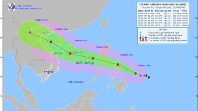
According to the meteorological agency, from this morning to noon, the center of the tropical depression was located over the sea of Quang Ninh , the strongest wind was level 7 (50-61km/h), gusting to level 9. The storm's circulation before weakening into a tropical depression caused strong winds in some places such as: Bach Long Vi with wind level 7, gusting to level 8, waves 2m high, Quang Ha (Quang Ninh) wind level 6, gusting to level 8, Cua Ong (Quang Ninh) wind level 6, many other places recorded gusting to level 6.
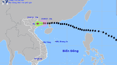
At 1 p.m., the tropical depression continued to weaken into a low pressure area with its center at about 21.5 degrees North latitude - 107.8 degrees East longitude, with the strongest wind speed below level 6 (below 39 km/h). It is forecasted that in the next 12 hours, the low pressure area will move west and gradually dissipate.

Although the storm weakened before reaching the shore and dissipated into a tropical depression, the Vietnam Meteorological Agency warned that from the afternoon of September 25 to the night of September 26, the North, Thanh Hoa, and Nghe An will have heavy to very heavy rain of 80-180mm, with some places experiencing over 300mm. There is a high risk of flooding in urban areas, flash floods on small rivers and streams, and landslides in steep areas.
From September 25 to 27, rivers in the North, Thanh Hoa, Nghe An are likely to experience floods, flood peaks on rivers: Thao, Lo, upstream of Thai Binh River, Hoang Long River, Buoi River, upstream of Ma River at alert level 1-2, some places above alert level 2.
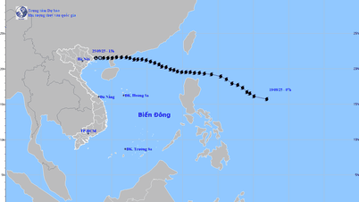
* Meanwhile, regarding the development of the tropical depression, Dr. Hoang Phuc Lam, Deputy Director of the National Center for Hydro-Meteorological Forecasting, said that the tropical depression caused strong winds in many areas in Hai Phong, Quang Ninh, Ninh Binh and Hung Yen. Accordingly, on the morning of September 25, after entering the sea of Quang Ninh, storm No. 9 weakened into a tropical depression.
Due to the influence of storm No. 9, in Bach Long Vi special zone (Hai Phong), there were strong winds of level 7, gusts of level 8, waves 2m high; Quang Ha (Quang Ninh) had strong winds of level 6, gusts of level 8; Cua Ong (Quang Ninh) had strong winds of level 6; Mong Cai (Quang Ninh), Phu Lien (Hai Phong), Van Ly (Ninh Binh) and Vu Ninh (Hung Yen) had gusts of level 6.
At 10:00, the center of the tropical depression was at about 21.5 degrees North latitude; 108.4 degrees East longitude, over the sea of Quang Ninh. The strongest wind near the center of the tropical depression was level 7 (50-61 km/h), gusting to level 9. Moving westward at a speed of 15-20 km/h.
Forecast, by 10pm on September 25, the tropical depression on the mainland of the Northeast region with wind speed below level 6; moving west at a speed of about 20km/h, gradually weakening into a low pressure area. The affected area is on the mainland of the Northeast region. Natural disaster risk level 3.
Due to the impact of the tropical depression, the Northern Gulf of Tonkin (including Bach Long Vy, Van Don, Co To, Cat Hai and Hon Dau islands) has strong winds of level 6-7, gusts of level 9, waves 2-3m high; rough seas.
Ships, boats, and aquaculture areas in the above-mentioned danger zones are all strongly affected by strong winds and large waves.
On land, coastal areas from Quang Ninh to Hai Phong have strong winds of level 6, in some places level 7, gusting to level 8-9; deep inland areas in the Northeast have strong gusts of level 6-7.
From the afternoon of September 25 to the end of the night of September 26 , in the Northern region, Thanh Hoa and Nghe An, there will be heavy rain, some places will have very heavy rain with common rainfall of 80-180mm, some places will have over 300mm. Beware of heavy rain causing urban flooding.
From September 25 to September 27, there is a possibility of a flood on rivers in the Northern region, Thanh Hoa, Nghe An. The flood peak on Thao River, Lo River, upstream Thai Binh River, Hoang Long River, Buoi River, upstream Ma River will reach alert level 1-alarm level 2, with some rivers above alert level 2.
Heavy rains can cause flooding in low-lying areas; flash floods in small rivers and streams, and landslides on steep slopes.
Source: https://www.sggp.org.vn/bao-so-9-ragasa-tan-thanh-vung-ap-thap-post814662.html


![[Photo] Prime Minister Pham Minh Chinh attends the groundbreaking ceremony of two key projects in Hai Phong city](https://vphoto.vietnam.vn/thumb/1200x675/vietnam/resource/IMAGE/2025/9/27/6adba56d5d94403093a074ac6496ec9d)


Comment (0)