
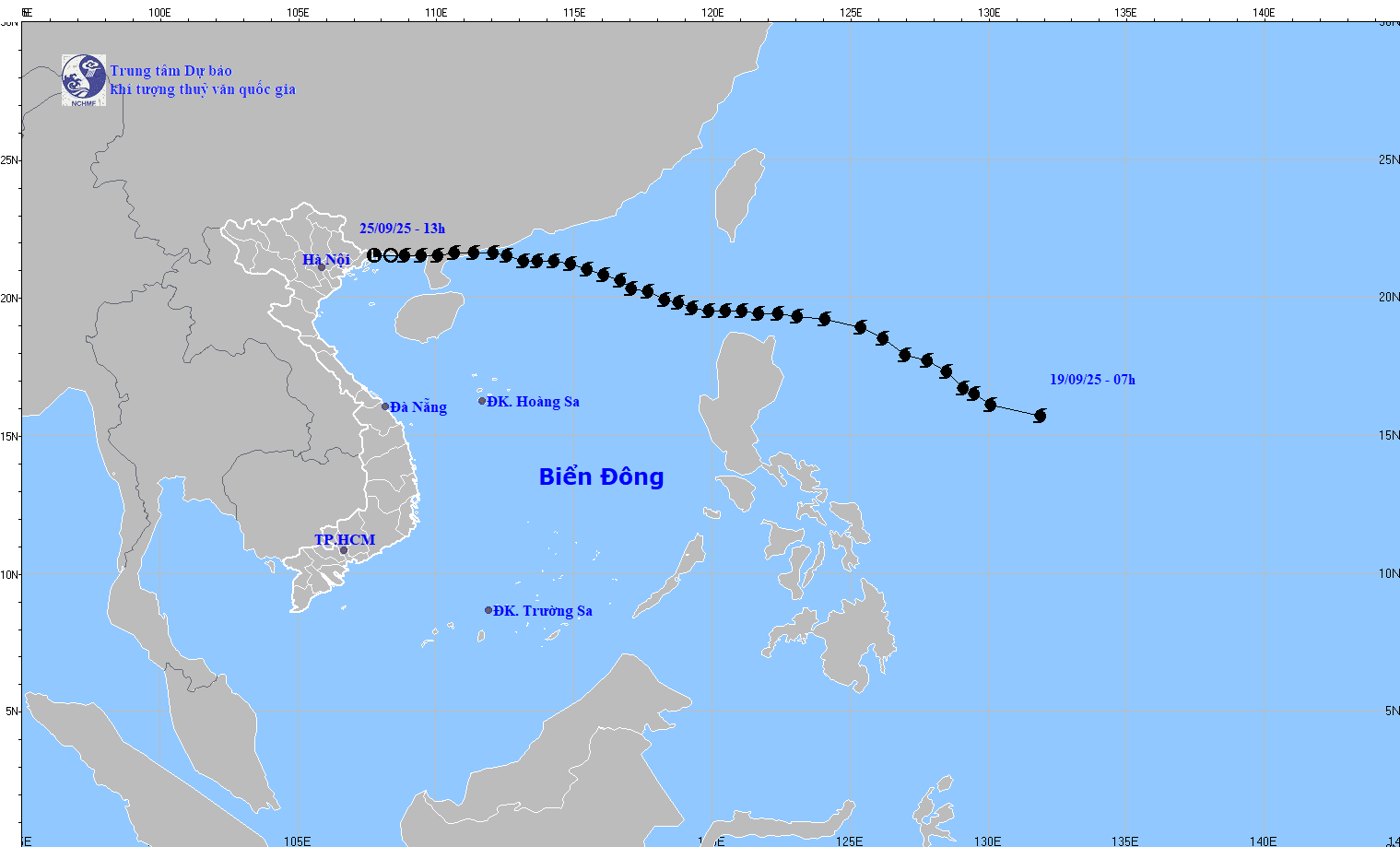
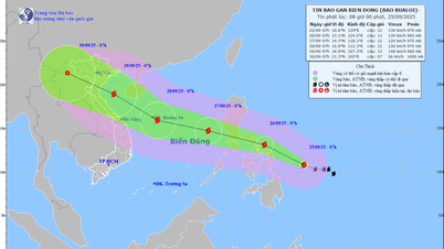
At 1 p.m. on September 25, the low pressure area was located at about 21.5 degrees North latitude; 107.8 degrees East longitude. The strongest wind in the center of the low pressure area was below level 6 (below 39 km/h).
Regarding storm BUALOI, Dr. Hoang Phuc Lam, Deputy Director of the National Center for Hydro-Meteorological Forecasting, said that around the night of September 26, storm BUALOI will enter the eastern sea area of the central East Sea, becoming storm number 10 in 2025.
Accordingly, at 1 p.m. on September 25, the center of the storm was at about 11.1 degrees North latitude; 128.1 degrees East longitude, in the sea east of the Philippines. The strongest wind near the center of the storm was level 12 (118-133 km/h), gusting to level 15. Moving in the West Northwest direction at a speed of 15-20 km/h.
At 1:00 p.m. on September 26, the center of the storm was at about 13.1 degrees North latitude; 123.2 degrees East longitude with strong winds of level 12, gusts of level 15; moving in the West Northwest direction at a speed of about 20 km/h.
As of September 27, the storm is located at approximately 14.8 degrees North latitude; 117.5 degrees East longitude with strong winds of level 12, gusts of level 15; moving in the West Northwest direction into the East Sea at a speed of approximately 25 km/h. The affected area is the East of the North and the middle of the East Sea. Disaster risk level 3.
As of 1 p.m. on September 28, the storm was located at approximately 16.4 degrees North latitude; 111 degrees East longitude with strong winds of level 2-13, gusting to level 16; moving in the West Northwest direction at a speed of approximately 25 km/h and likely to intensify. The affected area is the North and Central East Sea (including Hoang Sa special zone). Natural disaster risk level 3.
From the next 72 to 120 hours, the storm continued to move rapidly in the Northwest direction, traveling about 25 km per hour.
Due to the impact of the storm, from the evening of September 26, the sea area east of the North and the middle of the East Sea had strong winds of level 6-7, then increased to level 8-9, the area near the storm's center had winds of level 10-12, gusts of level 15, waves over 5-7m high, and rough seas.
Vessels operating in the above mentioned dangerous areas are susceptible to the impact of storms, whirlwinds, strong winds and large waves.
Source: https://baotintuc.vn/van-de-quan-tam/tin-cuoi-cung-ve-con-bao-so-9-20250925145625080.htm


![[Photo] Prime Minister Pham Minh Chinh attends the groundbreaking ceremony of two key projects in Hai Phong city](https://vphoto.vietnam.vn/thumb/1200x675/vietnam/resource/IMAGE/2025/9/27/6adba56d5d94403093a074ac6496ec9d)


Comment (0)