
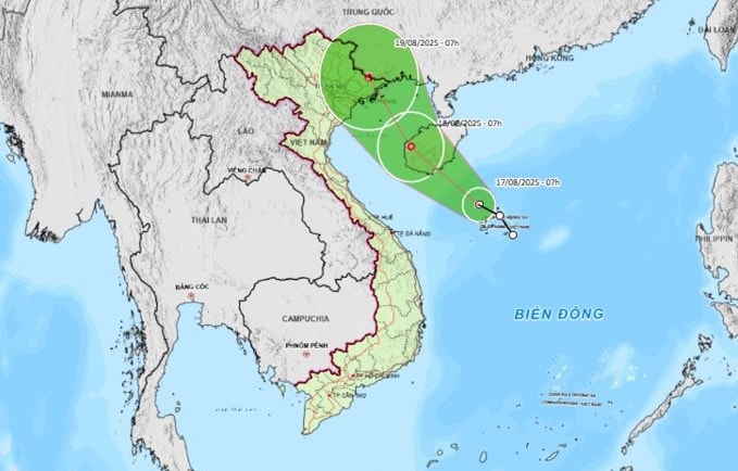
According to the forecast of the National Center for Hydro-Meteorological Forecasting, at 7:00 a.m. on August 18, the center of the tropical depression was at about 19.2 degrees north latitude, 108.9 degrees east longitude, on the mainland west of Hainan Island (China) with the strongest wind at level 6, gusting to level 8.
The tropical depression continued to move northwest at a speed of about 15 km/h and then gradually weakened into a low pressure area.
At 7:00 a.m. on August 19, the center of the tropical depression was at about 21.7 degrees north latitude, 107.3 degrees east longitude, on the Vietnam - China border area with the strongest wind speed reduced to below level 6.
Due to the influence of the tropical depression, the western area of the North East Sea (including the Hoang Sa special zone) will have thunderstorms and strong winds of level 6-7, gusts of level 8-9, waves 2-3.5m high, and rough seas.
From early morning of August 18, the Gulf of Tonkin has had winds gradually increasing to level 6, gusting to level 8, waves 2-3m high, and rough seas.
During the day and night of August 17, the Northwest, Hue city and the South Central Coast, the Central Highlands and the South will have scattered showers and thunderstorms, locally heavy to very heavy rain with rainfall of 10-30mm, locally over 80mm, with a risk of rain with intensity greater than 100mm in 3 hours.
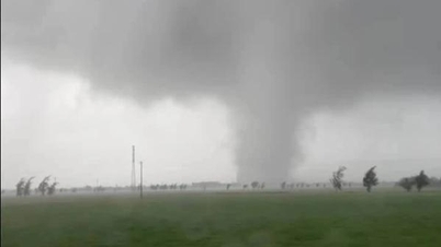
Thunderstorms may contain tornadoes, lightning, hail and strong winds.
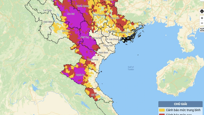
During the day and night of August 19, the Northeast and Thanh Hoa regions will have moderate rain, heavy rain and thunderstorms, locally very heavy rain with common rainfall of 30-80mm, locally over 150mm.
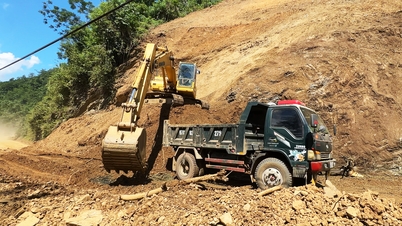
Heavy rain can cause flooding in low-lying areas, urban and industrial areas; flash floods in small rivers and streams; and landslides on steep slopes.
The Steering Committee for Natural Disaster Prevention, Search and Rescue and Civil Defense of Da Nang City has issued a dispatch requesting departments, branches, units and localities to proactively respond to the developments of the tropical depression in the East Sea.
Accordingly, the City Military Command, the City Border Guard Command, the Department of Agriculture and Environment, the Da Nang Coastal Information Station, the Department of Sea, Islands and Fisheries, coastal localities and relevant units monitor and promptly notify owners of vehicles and boats still operating at sea of information on the tropical depression so that they can proactively avoid, escape or not move into dangerous areas at sea.
The City Border Guard Command proactively manages ships going out to sea, organizes ship counting...
Armed forces units, departments, branches, localities and relevant units closely monitor the development of the tropical depression and weather reports, warnings of thunderstorms, tornadoes, lightning... to proactively handle possible situations...
Source: https://baodanang.vn/da-nang-ban-hanh-cong-dien-chu-dong-ung-pho-voi-dien-bien-cua-ap-thap-nhiet-doi-3299609.html

![[Photo] National Assembly Chairman Tran Thanh Man chairs the 8th Conference of full-time National Assembly deputies](https://vphoto.vietnam.vn/thumb/1200x675/vietnam/resource/IMAGE/2025/9/29/2c21459bc38d44ffaacd679ab9a0477c)
![[Photo] Many streets in Hanoi were flooded due to the effects of storm Bualoi](https://vphoto.vietnam.vn/thumb/1200x675/vietnam/resource/IMAGE/2025/9/29/18b658aa0fa2495c927ade4bbe0096df)
![[Photo] General Secretary To Lam attends the ceremony to celebrate the 80th anniversary of the post and telecommunications sector and the 66th anniversary of the science and technology sector.](https://vphoto.vietnam.vn/thumb/1200x675/vietnam/resource/IMAGE/2025/9/29/8e86b39b8fe44121a2b14a031f4cef46)

![[Photo] General Secretary To Lam receives US Ambassador to Vietnam Marc Knapper](https://vphoto.vietnam.vn/thumb/1200x675/vietnam/resource/IMAGE/2025/9/29/c8fd0761aa184da7814aee57d87c49b3)


Comment (0)