

According to the National Center for Hydro-Meteorological Forecasting, today (July 30), the hot weather continues to spread across the entire Northern region and provinces from Thanh Hoa to Da Nang , and the eastern provinces from Quang Ngai to Dak Lak and Khanh Hoa, with some areas experiencing severe heat. The lowest relative humidity is commonly 55 - 60%.
From the night of July 30 and July 31, rain will appear first in mountainous and midland areas. Scattered showers and thunderstorms, locally heavy rain at night, and scattered showers and thunderstorms during the day.
Other areas have scattered showers and thunderstorms; in particular, the western region of Quang Tri province, the Central Highlands and the South have scattered showers and thunderstorms, locally heavy rain with rainfall of 10 - 30 mm, locally over 60 mm.
People should be on guard against thunderstorms that may include tornadoes, lightning, hail and strong gusts of wind. Localized heavy rains may cause flash floods in small rivers and streams, landslides on steep slopes and flooding in low-lying areas.
On July 31, heat waves still appear in the Northern Delta and Thanh Hoa to Da Nang, the eastern provinces from Quang Ngai to Dak Lak , Khanh Hoa. The highest temperature is generally 35 - 37 degrees Celsius, some places over 37 degrees Celsius. Other places in the North have localized heat waves with the highest temperature in some places over 35 degrees Celsius. In the evening and at night, there are showers and thunderstorms in some places.
It is forecasted that from August 1, the heat wave in the Northern region will end, while the heat wave in the Central region is likely to last for many days to come.
The meteorological agency warns of a level 1 risk of natural disasters due to heat waves. Due to the effects of heat waves, some places will experience intense heat combined with low humidity, so there is a high risk of explosions and fires in residential areas due to increased demand for electricity, along with the risk of forest fires.
In addition, heat can also cause dehydration, exhaustion, and heat stroke in the human body when exposed to high temperatures for a long time.
The meteorological agency noted that the forecast temperature in the heat bulletin and the actual temperature felt outdoors can differ by 2-4 degrees Celsius, or even higher, depending on the conditions of the surface such as concrete and asphalt.
Thunderstorm warning in Hanoi
Information from the National Center for Hydro-Meteorological Forecasting, currently on satellite images and weather radar images, shows that convective clouds are developing in the areas of wards/communes: Vinh Hung, Hoang Mai, Linh Nam, Tuong Mai, Yen So, Thanh Tri, Bat Trang, Gia Lam. The cloud area tends to develop and expand further towards the inner city of Hanoi.
Warning, from now until 5:40 p.m. on July 30, the above areas and wards: Bach Mai, Phuong Liet, Dinh Cong, Hoang Liet, Long Bien ... will have showers and thunderstorms. The thunderstorm area is likely to continue to expand to other wards in Hanoi's inner city. During the rain, there is a possibility of tornadoes, lightning and strong gusts of wind.
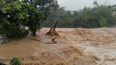
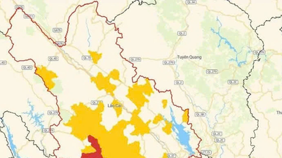
Flash flood and landslide warning in Lao Cai and Tuyen Quang
In the past 2 hours (from 2:00 p.m. to 4:00 p.m. on July 30), Lao Cai and Tuyen Quang provinces had moderate to heavy rain such as: Nam Muoi 1 42.6 mm, Dong Khe 34.6 mm (Lao Cai); Tan Trinh 57 mm, Tan Nam 2 34 mm (Tuyen Quang)...
In the next 3-6 hours, Lao Cai and Tuyen Quang provinces will continue to have rain with accumulated rainfall ranging from 20-40 mm, in some places over 80 mm.
In the next 6 hours, there is a risk of flash floods on small rivers and streams, and landslides on steep slopes in many communes and wards.


Warning level of natural disaster risk due to flash floods, landslides, land subsidence due to heavy rain or water flow at level 1.
The meteorological agency warned that flash floods and landslides could have a very negative impact on the environment, threaten people's lives; cause local traffic congestion, affect the movement of vehicles; destroy civil and economic works, causing damage to production and socio-economic activities.
Strong winds and high waves in many coastal areas
The National Center for Hydro-Meteorological Forecasting said that in the northern sea area of the North East Sea, there will be scattered showers and thunderstorms; in Phu Quy special zone, there will be strong southwest winds of level 6.
Forecast, on the night of July 30 and July 31, the North and Central East Sea (including Hoang Sa special zone) will have strong winds of level 6 - 7, gusting to level 8 - 9, rough seas, and waves 3 - 5 m high.
The sea area from Gia Lai to Ho Chi Minh City has strong winds of level 6, gusts of level 7 - 8, rough seas, waves 2 - 3.5 m high.
In addition, on the night of July 30 and July 31, the northern sea area of the North East Sea, the sea area from Ca Mau to An Giang and the Gulf of Thailand will have scattered showers and thunderstorms, with the possibility of tornadoes and strong gusts of wind of level 7-8.
Warning: on the night of July 31 and on August 1, the North and Central East Sea (including Hoang Sa special zone) will have strong southwest winds of level 6, sometimes level 7, gusting to level 8 - 9; waves 2 - 5 m high, rough seas. The sea area from Gia Lai to Lam Dong will have strong southwest winds of level 6, gusting to level 7 - 8; waves 2 - 3 m high, rough seas.
Level 2 risk of natural disasters due to strong winds at sea.
All vessels operating in the above areas are at high risk of being affected by cyclones, strong winds and large waves.
Weather forecast for regions on the night of July 30 and July 31:
In Hanoi, there will be scattered showers and thunderstorms at night, with the possibility of tornadoes, lightning and strong gusts of wind; hot during the day, scattered showers and thunderstorms in the evening, with heavy rain in some places. Lowest temperature 27 - 29 degrees Celsius. Highest temperature 35 - 37 degrees Celsius.
In the Northwest, in the evening and at night, there will be scattered showers and thunderstorms, with some places having heavy rain, with the possibility of tornadoes, lightning and strong gusts of wind. During the day, there will be scattered showers and thunderstorms, with some places having hot sun. Light wind. The lowest temperature is 25 - 28 degrees Celsius, in some places below 24 degrees Celsius. The highest temperature is 32 - 35 degrees Celsius, in some places above 35 degrees Celsius.
In the Northeast, in the evening and at night, there will be scattered showers and thunderstorms, hot and sunny during the day, with some places experiencing severe heat; in mountainous areas, on the night of July 30 and afternoon of July 31, there will be scattered showers and thunderstorms, with some places experiencing heavy rain, with the possibility of tornadoes, lightning and strong gusts of wind during the thunderstorms; in the day, there will be scattered showers and thunderstorms, with some places experiencing heat. Light wind. The lowest temperature is from 25 to 28 degrees Celsius. The highest temperature is 35 to 37 degrees Celsius in some places, in mountainous areas, 32 to 35 degrees Celsius, with some places experiencing over 35 degrees Celsius.
Provinces and cities from Thanh Hoa to Hue , in the late afternoon and at night, there will be showers and thunderstorms in some places, with the possibility of tornadoes, lightning and strong gusts of wind during thunderstorms; hot during the day, with some places experiencing intense heat. Southwest wind level 2 - 3. Lowest temperature 26 - 29 degrees Celsius. Highest temperature 34 - 37 degrees Celsius, in the North, some places will be over 37 degrees Celsius.
In the South Central Coast, in the evening and at night, there will be showers and thunderstorms in some places, with the possibility of tornadoes, lightning and strong gusts of wind; sunny during the day, especially in the East from Quang Ngai to Dak Lak and Khanh Hoa, it will be hot and sunny, with some places experiencing severe heat. Southwest wind level 2 - 3. Lowest temperature 26 - 29 degrees Celsius. Highest temperature 34 - 37 degrees Celsius, with some places above 37 degrees Celsius; in the South, 32 - 35 degrees Celsius.
The Central Highlands region has scattered showers and thunderstorms, with scattered showers and thunderstorms in the afternoon and evening. There is a possibility of tornadoes, lightning and strong gusts of wind in thunderstorms, with heavy rain in some places. Southwest wind level 2 - 3. Lowest temperature 20 - 23 degrees Celsius. Highest temperature 27 - 30 degrees Celsius, with some places above 30 degrees Celsius.
The Southern region has scattered showers and thunderstorms, with scattered showers and thunderstorms in the afternoon and evening, with some places having heavy rain. During thunderstorms, there is a possibility of tornadoes, lightning and strong gusts of wind. Southwest wind level 2 - 3. Lowest temperature 25 - 28 degrees Celsius. Highest temperature 32 - 35 degrees Celsius.
Ho Chi Minh City has scattered showers and thunderstorms, especially in the afternoon and evening, with scattered showers and thunderstorms, with some places having heavy rain. During thunderstorms, there is a possibility of tornadoes, lightning and strong gusts of wind. Southwest wind level 2 - 3. Lowest temperature 25 - 27 degrees Celsius. Highest temperature 32 - 35 degrees Celsius.
Source: https://baolaocai.vn/nang-nong-o-bac-bo-ket-thuc-tu-18-canh-bao-lu-quet-sat-lo-dat-o-lao-cai-tuyen-quang-post650123.html


![[Photo] Prime Minister Pham Minh Chinh chairs meeting to deploy overcoming consequences of storm No. 10](https://vphoto.vietnam.vn/thumb/1200x675/vietnam/resource/IMAGE/2025/10/3/544f420dcc844463898fcbef46247d16)
![[Photo] Students of Binh Minh Primary School enjoy the full moon festival, receiving the joys of childhood](https://vphoto.vietnam.vn/thumb/1200x675/vietnam/resource/IMAGE/2025/10/3/8cf8abef22fe4471be400a818912cb85)


Comment (0)