
 |
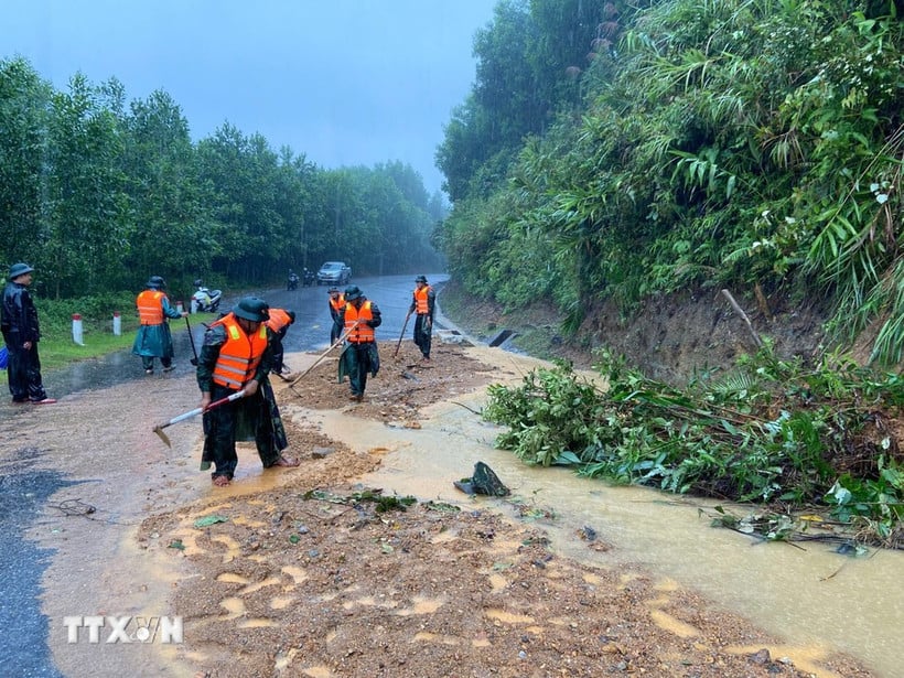
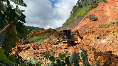
Risk of heavy rain, floods, and flash floods due to storms. (Illustration photo. Source: VNA) |
Director of the Department of Hydrometeorology ( Ministry of Agriculture and Environment ) Nguyen Thuong Hien said that storm No. 10 has made landfall, but in the coming days, the risk of heavy rain, floods, flash floods and landslides caused by the storm is still very high.
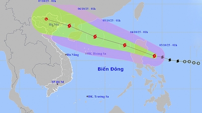
The development of storm No. 10 shows that this is the fastest moving storm ever in the East Sea. It only took about 2 days from the evening of September 26 to the evening of September 28 for the storm to travel more than 1,000km, directly impacting the mainland of the North and Central regions.
At 9:00 a.m. today (September 29), the center of the storm was at approximately 19.0 degrees North latitude; 104.7 degrees East longitude, on the mainland border area of Nghe An - Central Laos. The strongest wind was level 9 (moving at a speed of 75-88 km/h), gusting to level 11.
According to the forecast of the national hydrometeorological agency, in the next 3 hours, storm No. 10 will continue to move in the West Northwest direction, at a speed of about 20km/hour.
It is forecasted that by 7 p.m. today (September 29), the storm will move west-northwest at a speed of about 20-25 km/hour, moving inland, then gradually weakening into a tropical depression, then a low pressure area. The strongest wind speed is below level 6.
The affected area (at the forecast time this morning) is the sea from Thanh Hoa to Quang Tri (including Hon Ngu island, Con Co special economic zone); Northern Bac Bo Gulf (including Bach Long Vi special economic zones, Van Don, Co To, Cat Hai and Hon Dau island).
Notably, due to the impact of the storm, the coastal areas and islands of the provinces from Quang Ninh to Nghe An have storm surges of 0.5-1.0m high. Warning of the risk of flooding in low-lying coastal areas and river mouths due to storm surges combined with high tides and big waves in the morning and afternoon of September 29.
On land, from Quang Ninh to Ha Tinh, wind level 6-7, gust level 8-9, in some places level 8, gust level 10; near the storm center level 8-9, gust level 12.
From now until tomorrow (September 30), in the area from Thanh Hoa to Ha Tinh, the Northern Delta, Phu Tho, the southern provinces of Son La and Lao Cai, there will be heavy to very heavy rain. The rainfall is generally 100-200mm, locally over 350mm. During thunderstorms, there is a possibility of tornadoes, lightning, hail and strong gusts of wind.
From the night of September 30, rain in the above areas gradually decreased. The risk level of natural disasters due to heavy rain, tornadoes, lightning, and hail is forecast at level 1 over a wide area. Particularly in the area from Thanh Hoa to Ha Tinh, the risk level of natural disasters is level 2.
Sharing with the press, Mr. Nguyen Thuong Hien said that from now until October 1, on rivers in the Northern region, from Thanh Hoa to Quang Tri, there is a possibility of a flood, especially paying attention to medium and large floods concentrated on Thao River (Lao Cai), Hoang Long (Ninh Binh), Ma River, Chu (Thanh Hoa), Ca River (Nghe An), Ngan Sau, Ngan Pho, La (Linh Cam), Gianh, Kien Giang (Quang Tri).
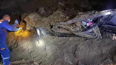
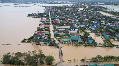
In particular, there is a risk of widespread flooding from Thanh Hoa to Ha Tinh and a high risk of flash floods and landslides in the western communes of Thanh Hoa, Nghe An and Ha Tinh provinces. In addition, due to the impact of heavy rain from storm No. 10, there is a possibility of localized flooding in the southern part of the Northern Delta.
Thus, although storm No. 10 has made landfall, in the coming days, the risk of heavy rain, floods, flash floods and landslides caused by storm No. 10 is still very high.
In response to the above developments, Mr. Hien said that implementing the urgent direction of the Prime Minister and the Ministry of Agriculture and Environment, the Department of Hydrometeorology has requested the entire national hydrometeorological system to maintain the highest forecast and warning mode to ensure the provision of the most complete, timely and accurate information for response work.
In recent days, the National Center for Hydro-Meteorological Forecasting has closely coordinated with relevant units to closely monitor storm developments, continuously update strong winds and heavy rains, and issue timely and reliable forecasts and warnings, effectively serving local disaster prevention work.
On that basis, the Northern and Central Hydrometeorological Stations have also directed the provincial Hydrometeorological Stations to increase detailed bulletins and directly advise the Civil Defense Command and local authorities on the risks of heavy rain, floods, flash floods, and landslides to make response decisions before, during, and after the storm.
Hydrometeorological monitoring stations also conduct 24/7 enhanced monitoring, ensuring timely and safe data transmission to staff.
The Center for Hydrometeorological Observation Technology maintains the stable operation of the entire weather radar network, providing accurate information on storm center and intensity; the Center for Hydrometeorological Investigation, Survey, Services and Technology ensures the stable operation of enhanced automatic monitoring stations in the Central provinces.
“All these measures are aimed at strictly implementing the Prime Minister's direction, helping authorities and people proactively deploy appropriate and effective response plans, minimizing damage caused by storm No. 10,” the Director of the Department of Hydrometeorology emphasized./.
Source: https://huengaynay.vn/chinh-tri-xa-hoi/theo-dong-thoi-su/nguy-co-mua-lon-lu-quet-va-sat-lo-dat-ngay-sau-bao-so-10-van-con-rat-lon-158278.html


![[Photo] Binh Trieu 1 Bridge has been completed, raised by 1.1m, and will open to traffic at the end of November.](https://vphoto.vietnam.vn/thumb/1200x675/vietnam/resource/IMAGE/2025/10/2/a6549e2a3b5848a1ba76a1ded6141fae)


Comment (0)