

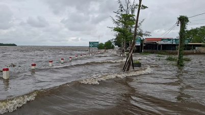
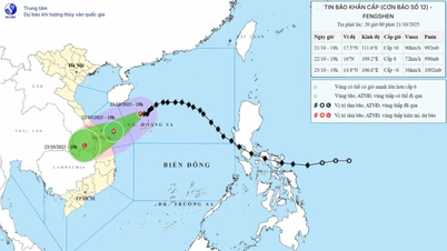
According to updated data, the eye of the storm may make landfall in the Da Nang - Quang Ngai area, then weaken into a tropical depression. Previously, the meteorological agency said the storm may weaken into a tropical depression before making landfall.
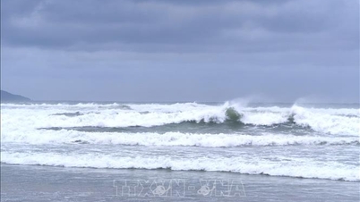
Specifically, at 10:00 a.m. the same day, the storm center was at about 17.8 degrees North latitude - 112.4 degrees East longitude, about 125km North of Hoang Sa archipelago. The strongest wind near the storm center was still at level 9-10 (75-102km/h), gusting to level 12. At this time, the storm was moving in a southwest direction, at a speed of 10-15km/h.
The National Center for Hydro-Meteorological Forecasting said that in the next 24 to 48 hours, the storm will continue to move southwest at a speed of 10-15km/hour, but the wind will still be at level 8, gusting to level 10.
Then, from October 22 to the morning of October 23, the storm continued to move southwest at a speed of 10-15km/hour, entering the mainland through the Da Nang - Quang Ngai area, weakening into a tropical depression and then a low pressure area.
The meteorological agency continues to warn of the risk of very heavy rain that will last for many days until the end of October in the Central region. The cause of the rain is due to the influence of storm circulation combined with cold air and East wind, and terrain effects. From the night of October 22 to 27, the area from Ha Tinh to Quang Ngai will have widespread heavy rain. In particular, Ha Tinh - North Quang Tri and Quang Ngai: 200-400mm, some places over 500mm; South Quang Tri - Da Nang: 500-700mm, some places over 900mm.
Source: https://www.sggp.org.vn/tam-bao-co-the-do-bo-dat-lien-trung-bo-post819136.html
![[Photo] Prime Minister Pham Minh Chinh meets with Speaker of the Hungarian National Assembly Kover Laszlo](https://vphoto.vietnam.vn/thumb/1200x675/vietnam/resource/IMAGE/2025/10/20/1760970413415_dsc-8111-jpg.webp)

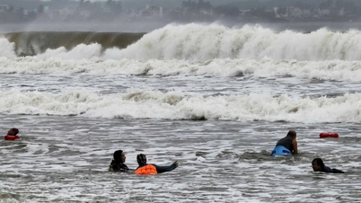
![[Photo] Da Nang residents "hunt for photos" of big waves at the mouth of the Han River](https://vphoto.vietnam.vn/thumb/1200x675/vietnam/resource/IMAGE/2025/10/21/1761043632309_ndo_br_11-jpg.webp)
![[Photo] Prime Minister Pham Minh Chinh received Mr. Yamamoto Ichita, Governor of Gunma Province (Japan)](https://vphoto.vietnam.vn/thumb/1200x675/vietnam/resource/IMAGE/2025/10/21/1761032833411_dsc-8867-jpg.webp)


Comment (0)