
Forecast in the next 24-72 hours, the storm will move west, then west-southwest, speed 10-15km/hour. At 7:00 p.m. on October 21, the center of storm No. 12 will be in the sea north of Hoang Sa, with a strong intensity of level 11, gusting to level 13.
Due to the influence of storm No. 12, the sea area of the North East Sea (including Hoang Sa special zone): Wind level 7-8, near the storm center level 9-11, gusting to level 13; waves 3-5m high, 5-7m near the storm center, very rough seas. The sea area of South Quang Tri - Quang Ngai (including Ly Son special zone): Wind level 6, from the morning of October 22 increasing to level 7, near the storm center level 8-9, gusting to level 11; waves 3-5m high, very rough seas.
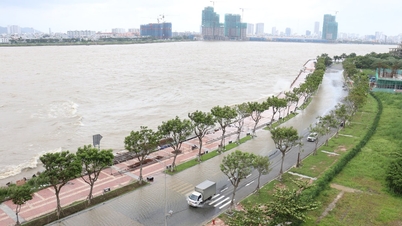
Due to the storm combined with cold air and East wind disturbances, from the night of October 22 to 26, the Ha Tinh-Quang Ngai area will have widespread heavy rain, specifically: Ha Tinh-North Quang Tri and Quang Ngai rainfall of 200-400mm, locally over 500mm. South Quang Tri- Da Nang rainfall of 500-700mm, locally over 900mm. Heavy rain may last until the end of October 2025, with the risk of flash floods, landslides, and flooding of low-lying areas and urban areas.
Cold air boost
*Currently (October 21), cold air has weakly affected the North Central region and some places in the Northwest. At Bach Long Vy station, strong Northeast wind level 6, sometimes level 7, gusting to level 8 is recorded; Con Co station has strong Northeast wind level 6.
It is forecasted that during the day and night of October 21, cold air will continue to affect the Central Central region and some other places in the Northwest; Northeast wind level 3, coastal areas level 3-4.
At sea, due to the influence of cold air combined with the circulation of storm No. 12, the North East Sea area (including Hoang Sa archipelago) has strong northeast winds of level 7-8, near the storm center level 9-11, gusting to level 13, rough seas, waves 3-5m high, near the storm center 5-7m.
From South Quang Tri to Quang Ngai (including Ly Son Island): Northeast to North wind level 6, from the morning of October 22 increasing to level 7, near the storm center level 8-9, gusting to level 11, very rough seas, waves 3-5m high.
*According to the National Center for Hydro-Meteorological Forecasting, today's weather (October 21): Northern region will have sunny days, cold mornings, and some places will be freezing; Southern region will have scattered showers and thunderstorms, with some places having heavy rain; light winds.
Weather forecast for day and night October 21 as follows:
Northwest: Cloudy, scattered showers; sunny day; light wind; cold morning, some places are cold; temperature 19-31 degrees Celsius.
Northeast: Cloudy, no rain; sunny day; Northeast wind level 3, especially coastal areas level 3-4; cold morning, mountainous areas have cold weather; temperature 20-31 degrees Celsius.
Hanoi: Cloudy, no rain at night; sunny during the day; Northeast wind level 3; temperature 21-31 degrees Celsius.
From Thanh Hoa to Hue: Cloudy, scattered showers and thunderstorms; in the South, there will be rain, scattered showers and thunderstorms, locally heavy rain; North to Northwest wind level 3, coastal areas level 3-4; in thunderstorms, there is a possibility of tornadoes, lightning and strong gusts of wind; temperature 22-31 degrees Celsius.
South Central Coast: Cloudy, with rain, showers and scattered thunderstorms in the North, locally heavy rain in some places; showers and thunderstorms in the South, locally heavy rain in some places; Northeast wind level 2-3; in thunderstorms there is a possibility of tornadoes, lightning and strong gusts of wind; temperature 23-32 degrees Celsius.
Central Highlands: Cloudy, scattered showers and thunderstorms, locally heavy rain; light wind; thunderstorms with possibility of tornadoes, lightning, hail and strong gusts of wind; temperature 19-30 degrees Celsius.
Southern region: Cloudy, scattered showers and thunderstorms, locally heavy rain; light wind; thunderstorms with possibility of tornadoes, lightning, hail and strong gusts of wind; temperature 23-34 degrees Celsius.
Ho Chi Minh City: There will be showers and thunderstorms in some places, especially in the afternoon and evening, scattered showers and thunderstorms, locally heavy rain in some places, in thunderstorms there is a possibility of tornadoes, lightning, hail and strong gusts of wind; temperature 24-34 degrees Celsius.
Hoang Sa special economic zone (Da Nang): There will be storms; visibility is 4-10km, decreasing to 2-4km during storms; strong winds level 7-9, near the storm center level 9-11, gusting to level 13, rough seas; waves 3-5m high, near the storm center 5-7m.
Truong Sa special economic zone (Khanh Hoa): Showers and thunderstorms in some places; visibility over 10km; southwest wind level 3-4; waves 1.5-2.5m high.
According to People's Army Newspaper
Source: https://baoquangtri.vn/xa-hoi/202510/thoi-weather-hom-nay-21-10-bao-so-12-cuong-do-manh-cap-11-giat-cap-13-03c76f6/
![[Photo] Prime Minister Pham Minh Chinh meets with Speaker of the Hungarian National Assembly Kover Laszlo](https://vphoto.vietnam.vn/thumb/1200x675/vietnam/resource/IMAGE/2025/10/20/1760970413415_dsc-8111-jpg.webp)
![[Photo] Prime Minister Pham Minh Chinh received Mr. Yamamoto Ichita, Governor of Gunma Province (Japan)](https://vphoto.vietnam.vn/thumb/1200x675/vietnam/resource/IMAGE/2025/10/21/1761032833411_dsc-8867-jpg.webp)

![[Photo] National Assembly Chairman Tran Thanh Man holds talks with Hungarian National Assembly Chairman Kover Laszlo](https://vphoto.vietnam.vn/thumb/1200x675/vietnam/resource/IMAGE/2025/10/20/1760952711347_ndo_br_bnd-1603-jpg.webp)


Comment (0)