
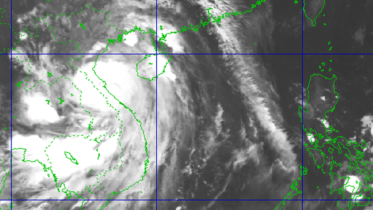
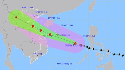
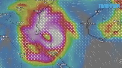
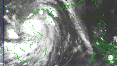
In the next 24 hours, the low pressure area will move in the West Northwest direction, about 15km per hour and is likely to strengthen into a tropical depression.
Due to the influence of the low pressure circulation, which is likely to strengthen into a tropical depression, the central area of the East Sea will have showers and thunderstorms, winds gradually increasing to level 5, sometimes level 6, gusting to level 8. Waves are 2-3 m high, rough seas. Ships operating in the area need to take proactive precautions to ensure safety.

The central East Sea area has heavy showers and thunderstorms, strong winds sometimes reaching level 6, gusting to level 8.
Currently, the tropical convergence zone has an axis through the central East Sea connecting with the low pressure area, causing showers and thunderstorms in the Gulf of Tonkin, the sea area from Da Nang to Ho Chi Minh City, the northern, central and southern East Sea areas (including the Hoang Sa and Truong Sa sea areas) as well as the Gulf of Thailand.
The North, Central and South East Sea (including Hoang Sa and Truong Sa seas), the Gulf of Tonkin, the sea from South Quang Tri to Ca Mau, from Ca Mau to An Giang and the Gulf of Thailand will have scattered showers and thunderstorms. During thunderstorms, there is a possibility of tornadoes, strong gusts of wind of level 6-7, and waves over 2m high.
In the central East Sea area, the wind gradually increases to level 5, sometimes level 6, gusting to level 8; rough sea.
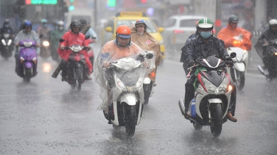
On land, from early morning to night of September 16, in mountainous areas, plains and coastal areas of the North, Thanh Hoa, Nghe An, there will be scattered showers and thunderstorms with rainfall of 10 - 30mm, locally over 60mm, concentrated in the morning and at night. In the afternoon and at night of the same day, the area from Da Nang to Lam Dong and the South will have scattered showers and thunderstorms of 15 - 30mm, locally over 80mm.
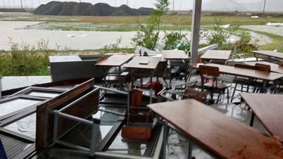
The meteorological agency warns of a high risk of heavy rain (>80mm/3 hours), accompanied by dangerous weather phenomena such as tornadoes, lightning, hail, and strong gusts of wind. There is a risk of flash floods on small rivers and streams, landslides on steep slopes, and flooding in low-lying areas.
Last night and early morning of September 16, many places recorded heavy rainfall. In Tuyen Quang, Nam Dan station measured 198mm; Lao Cai had Ta Cu Ty 105mm; Lam Dong had Tan Thanh 95.4mm; Dak Lak had Cu Kbang 83.8mm. Heavy rainfall can impact agricultural production, infrastructure, housing and traffic safety in localities.
Experts recommend that authorities and people in affected areas need to proactively prepare response plans, especially in mountainous areas, along rivers and streams, and areas that are frequently flooded; at the same time, closely monitor weather forecasts and warnings to promptly respond and minimize damage.
Weather forecast for regions across the country:
Hanoi capital is cloudy, with occasional showers and thunderstorms in the morning and at night; intermittent sunshine during the day. Southeast wind level 2 - 3. During thunderstorms, there is a possibility of tornadoes, lightning and strong gusts of wind. Lowest temperature 26 - 28 degrees Celsius. Highest temperature 33 - 35 degrees Celsius.
The Northwestern provinces are cloudy with scattered showers and thunderstorms. Light winds. Thunderstorms may include tornadoes, lightning, hail, and strong gusts of wind. The lowest temperature is 23 - 26 degrees Celsius, with some places below 22 degrees Celsius. The highest temperature is 31 - 34 degrees Celsius, with some places above 34 degrees Celsius.
The Northeastern region is cloudy, sunny during the day, with scattered showers and thunderstorms at night; in the plains and coastal areas and Tuyen Quang, there will be scattered showers and thunderstorms in the morning and at night, with some places having heavy rain. Southeast wind level 2 - 3. During thunderstorms, there is a possibility of tornadoes, lightning, hail and strong gusts of wind. The lowest temperature is 24 - 27 degrees Celsius, in mountainous areas, some places below 24 degrees Celsius. The highest temperature is 31 - 34 degrees Celsius, some places above 34 degrees Celsius.
Provinces from Thanh Hoa to Hue will be cloudy with scattered showers and thunderstorms, especially in Thanh Hoa and Nghe An, with scattered showers and thunderstorms, with some heavy rain. Light winds. During thunderstorms, there is a possibility of tornadoes, lightning, hail and strong gusts of wind. Lowest temperature 24 - 27 degrees Celsius. Highest temperature 31 - 34 degrees Celsius, with some places above 34 degrees Celsius.
The South Central Coast region is cloudy with scattered showers and thunderstorms in some places, scattered showers and thunderstorms in the afternoon and at night, and locally heavy rain in some places. Light wind in the North, westerly to southwest wind level 2 - 3 in the South. During thunderstorms, there is a possibility of tornadoes, lightning, hail and strong gusts of wind. Lowest temperature 24-27 degrees Celsius. Highest temperature 31 - 34 degrees Celsius, some places above 34 degrees Celsius.
The Central Highlands is cloudy with scattered showers and thunderstorms in some places. In the afternoon and at night, there will be scattered showers and thunderstorms, with some heavy rain in some places. Southwest wind level 2 - 3. During thunderstorms, there is a possibility of tornadoes, lightning, hail and strong gusts of wind. Lowest temperature 20 - 23 degrees Celsius. Highest temperature 28 - 31 degrees Celsius.
The South is cloudy with scattered showers and thunderstorms in some places. In the afternoon and at night, there will be scattered showers and thunderstorms, with some places having heavy rain. Southwest wind level 2 - 3. During thunderstorms, there is a possibility of tornadoes, lightning, hail and strong gusts of wind. Lowest temperature 23 - 26 degrees Celsius. Highest temperature 30 - 33 degrees Celsius, some places above 33 degrees Celsius.
Ho Chi Minh City is cloudy, sunny during the day, with occasional showers and thunderstorms in the afternoon and evening, and no rain at night. Southwest wind level 2-3. During thunderstorms, there is a possibility of tornadoes, lightning, hail, and strong gusts of wind. Lowest temperature 25-27 degrees Celsius. Highest temperature 32-34 degrees Celsius.
Source baotintuc.vn
Source: https://baophutho.vn/thoi-weather-ngay-16-9-vung-ap-thap-co-kha-nang-manh-len-thanh-ap-thap-nhiet-doi-239662.htm
![[Photo] The 4th meeting of the Inter-Parliamentary Cooperation Committee between the National Assembly of Vietnam and the State Duma of Russia](https://vphoto.vietnam.vn/thumb/1200x675/vietnam/resource/IMAGE/2025/9/28/9f9e84a38675449aa9c08b391e153183)
![[Photo] President Luong Cuong receives Chairman of the State Duma of the Russian Federation Vyacheslav Volodin](https://vphoto.vietnam.vn/thumb/1200x675/vietnam/resource/IMAGE/2025/9/29/6bd456e072504df3a468acbf9b7989c8)


![[Photo] Joy on the new Phong Chau bridge](https://vphoto.vietnam.vn/thumb/1200x675/vietnam/resource/IMAGE/2025/9/28/b00322b29c8043fbb8b6844fdd6c78ea)


![[Photo] President Luong Cuong receives Chairman of the State Duma of the Russian Federation Vyacheslav Volodin](https://vphoto.vietnam.vn/thumb/402x226/vietnam/resource/IMAGE/2025/9/29/6bd456e072504df3a468acbf9b7989c8)


Comment (0)