
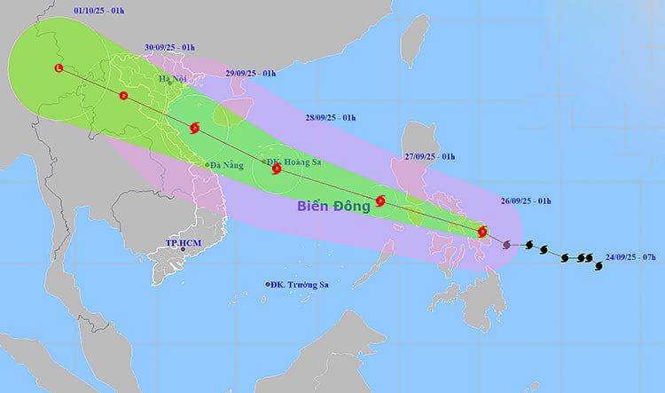
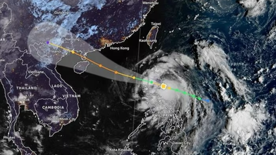
In the next 24-72 hours, storm Bualoi will continue to move rapidly and is likely to strengthen. At 1:00 a.m. on September 27, the storm center will be at about 13.8 degrees North latitude - 118.9 degrees East longitude, with winds of level 11, gusts of level 14. At 1:00 a.m. on September 28, the storm is likely to strengthen to level 12, gusts of level 15 when it is in the central area of the East Sea. In particular, in the early morning of September 29, the storm is expected to approach the North Central coast, with the storm center at about 18.3 degrees North latitude, 107.4 degrees East longitude, with winds of level 12-13, gusts of level 16, and then gradually weaken.
Due to the storm's influence, from the evening of September 26, the northeastern sea area and the central East Sea will have strong winds of level 6-7, later increasing to level 8-9; the area near the storm's center will have strong winds of level 10-12, gusting to level 15, waves 5-7 m high, and rough seas. Ships operating in the danger zone are at high risk of encountering thunderstorms, whirlwinds, strong winds, and large waves.
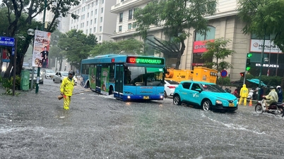
On the mainland, on the morning of September 26, the area from Ha Tinh to Da Nang and the Central Highlands had scattered showers and thunderstorms, locally heavy to very heavy rain, with rainfall generally exceeding 80 mm. Many places recorded heavy rainfall such as Vinh Tu (Quang Tri), Quan Tuong Dai (Hue City) 185.6 mm, Ho Thai Xuan (Da Nang) 83.6 mm.
In the next 24 hours, heavy rain is forecast to spread to the Northeast and South Phu Tho , with rainfall ranging from 30-70 mm, with some places over 150 mm. There is a risk of heavy rain with an intensity of over 100 mm/3 hours. In addition, during the day and night of September 26, the Northwest, from Thanh Hoa to Da Nang, the Central Highlands and the South, will continue to have scattered showers and thunderstorms, with localized heavy rain of over 80 mm.
During thunderstorms, there is a possibility of tornadoes, lightning, hail and strong gusts of wind. From the afternoon of September 27, heavy rain in the Northeast and South of Phu Tho will gradually decrease.
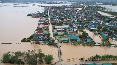
The meteorological agency warned that prolonged heavy rain could cause flooding in low-lying areas, urban areas, and industrial zones; flash floods on small rivers and streams; and landslides in mountainous areas.
Weather forecast for regions across the country:
Hanoi capital is cloudy with moderate rain, heavy rain and thunderstorms, locally very heavy rain. East wind level 2-3. During thunderstorms there is a possibility of tornadoes, lightning and strong gusts of wind. Lowest temperature 23-25 degrees Celsius. Highest temperature 28-30 degrees Celsius.
The Northwestern provinces are cloudy with scattered showers and thunderstorms, some places have heavy rain; in the South of Phu Tho, in the evening and at night, there will be moderate rain, heavy rain and thunderstorms, some places have very heavy rain. Light wind. During thunderstorms, there is a possibility of tornadoes, lightning and strong gusts of wind. The lowest temperature is 22-25 degrees Celsius, some places below 21 degrees Celsius. The highest temperature is 27-30 degrees Celsius.
The Northeastern region is cloudy with moderate to heavy rain and scattered thunderstorms, with some places experiencing very heavy rain. East wind level 2-3. During thunderstorms, there is a possibility of tornadoes, lightning and strong gusts of wind. The lowest temperature is 23-26 degrees Celsius. The highest temperature is 27-30 degrees Celsius, with some places above 30 degrees Celsius.
Provinces from Thanh Hoa to Hue are cloudy with scattered showers and thunderstorms, locally heavy to very heavy rain. Light wind. During thunderstorms, there is a possibility of tornadoes, lightning, hail and strong gusts of wind. Lowest temperature 23-26 degrees Celsius. Highest temperature 27-30 degrees Celsius.
The South Central Coast region is cloudy with scattered showers and thunderstorms, with some heavy rain in some places. West to southwest winds at level 2-3. During thunderstorms, there is a possibility of tornadoes, lightning, hail and strong gusts of wind. Lowest temperature 24-27 degrees Celsius. Highest temperature 30-33 degrees Celsius.
Central Highlands cloudy, scattered showers and thunderstorms, locally heavy rain (rain concentrated in the afternoon and night). Southwest wind level 2-3. During thunderstorms, there is a possibility of tornadoes, lightning, hail and strong gusts of wind. Lowest temperature 19-22 degrees Celsius. Highest temperature 25-28 degrees Celsius.
The South is cloudy with scattered showers and thunderstorms, with some places experiencing heavy rain (rain is concentrated in the afternoon and evening). Southwesterly winds level 2-3. During thunderstorms, there is a possibility of tornadoes, lightning, hail and strong gusts of wind. Lowest temperature 24-27 degrees Celsius. Highest temperature 30-33 degrees Celsius.
Ho Chi Minh City is cloudy with scattered showers and thunderstorms; in the late afternoon and evening there will be scattered showers and thunderstorms, with some heavy rain in some places. Southwest wind level 2-3. During thunderstorms there is a possibility of tornadoes, lightning, hail and strong gusts of wind. Lowest temperature 24-26 degrees Celsius. Highest temperature 31-33 degrees Celsius.
Source: https://baotintuc.vn/xa-hoi/thoi-weather-ngay-269-bao-bualoi-tien-nhanh-vao-bien-dong-canh-bao-mua-lon-dien-rong-20250926054029506.htm

![[Photo] Prime Minister Pham Minh Chinh launched a peak emulation campaign to achieve achievements in celebration of the 14th National Party Congress](https://vphoto.vietnam.vn/thumb/1200x675/vietnam/resource/IMAGE/2025/10/5/8869ec5cdbc740f58fbf2ae73f065076)


![[Photo] Bustling Mid-Autumn Festival at the Museum of Ethnology](https://vphoto.vietnam.vn/thumb/1200x675/vietnam/resource/IMAGE/2025/10/4/da8d5927734d4ca58e3eced14bc435a3)


![[VIDEO] Summary of Petrovietnam's 50th Anniversary Ceremony](https://vphoto.vietnam.vn/thumb/402x226/vietnam/resource/IMAGE/2025/10/4/abe133bdb8114793a16d4fe3e5bd0f12)

![[VIDEO] GENERAL SECRETARY TO LAM AWARDS PETROVIETNAM 8 GOLDEN WORDS: "PIONEER - EXCELLENT - SUSTAINABLE - GLOBAL"](https://vphoto.vietnam.vn/thumb/402x226/vietnam/resource/IMAGE/2025/7/23/c2fdb48863e846cfa9fb8e6ea9cf44e7)


Comment (0)