
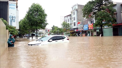
In particular, Lao Cai, Phu Tho and Tuyen Quang provinces recorded heavy rainfall, with many measuring stations exceeding 110mm such as Hoa Thuan Hydropower Station ( Cao Bang ), Tien Nguyen 2 Station (Tuyen Quang), Trung Tam 1 Station (Lao Cai), Huong Nhuong 2 Station (Phu Tho)...
It is forecasted that in the next 24 - 48 hours, heavy rain will still be concentrated in Lao Cai , Phu Tho, Tuyen Quang provinces with common rainfall of 40 - 80mm, some places over 150mm. Other areas in the North and Thanh Hoa will have rain from 20 - 50mm, locally over 100mm. Notably, in some places there is a possibility of heavy rain of over 100mm in just 3 hours, causing high danger. During thunderstorms, there may be whirlwinds, lightning, hail and strong gusts of wind.
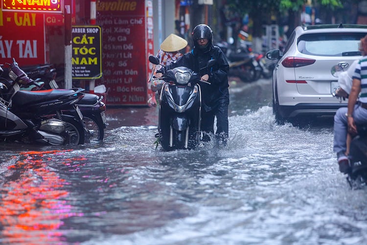
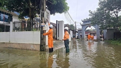
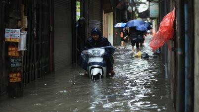
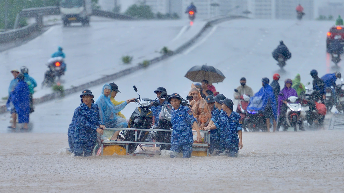
From the night of September 30, rain in the northern provinces and Thanh Hoa is forecast to gradually decrease. However, the meteorological agency warned that heavy rain on September 30 could cause flooding in low-lying areas, urban areas and industrial zones. Mountainous areas should be especially wary of flash floods on small rivers and streams and landslides on steep slopes.
At sea, at Hon Dau station, strong winds of level 6, sometimes level 7, gusts of level 8 - 9 were recorded. On September 30, the North of Bac Bo Gulf had strong southeast winds of level 6, gusts of level 7, waves of 2 - 4m high. From the afternoon, the wind will gradually decrease. On the night of September 30, the wind in the North of Bac Bo Gulf continued to weaken.
In addition, on the day and night of September 30, in the Gulf of Tonkin, the sea area from Binh Thuan to Ca Mau, from Ca Mau to Kien Giang and the Gulf of Thailand, there will be scattered showers and thunderstorms. During thunderstorms, there is a possibility of tornadoes, strong gusts of wind of level 6-7, and waves over 2m high. All vessels operating in the area should proactively monitor forecast information and take preventive measures to ensure safety.
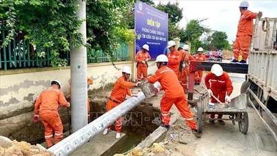
The meteorological agency recommends that local authorities and people continue to closely monitor the developments of floods and rains, proactively prepare plans to prevent natural disasters, and limit damage to people and property.
Weather forecast for regions across the country:
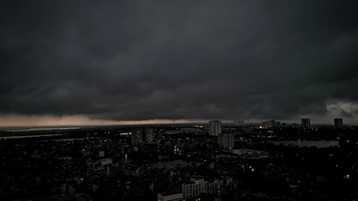
Hanoi capital is cloudy, with moderate rain, heavy rain and thunderstorms during the day, and very heavy rain in some places; the rain gradually decreases at night. East to southeast wind level 2 - 3. During thunderstorms, there is a possibility of tornadoes, lightning and strong gusts of wind. Lowest temperature 24 - 26 degrees Celsius. Highest temperature 28 - 30 degrees Celsius.
The Northwestern provinces are cloudy with moderate to heavy rain and scattered thunderstorms, with some places experiencing very heavy rain, especially in Lao Cai and the South of Phu Tho; the rain gradually decreases at night. Light winds. During thunderstorms, there is a possibility of tornadoes, lightning and strong gusts of wind. The lowest temperature is 21 - 24 degrees Celsius, in some places below 20 degrees Celsius. The highest temperature is 26 - 29 degrees Celsius.
The Northeastern region is cloudy with moderate to heavy rain and scattered thunderstorms, locally very heavy rain; the rain gradually decreases at night. East to southeast wind level 2 - 3. During thunderstorms, there is a possibility of tornadoes, lightning and strong gusts of wind. Lowest temperature 23 - 26 degrees Celsius. Highest temperature 27 - 30 degrees Celsius.
Provinces from Thanh Hoa to Hue will be cloudy with scattered showers and thunderstorms. Southeast winds will be at level 2-3. During thunderstorms, there is a possibility of tornadoes, lightning and strong gusts of wind. Lowest temperature 23-26 degrees Celsius. Highest temperature 30-33 degrees Celsius.
The South Central Coast region is cloudy with scattered showers and thunderstorms, sunny during the day. East wind in the North, south wind level 2-3 in the South. During thunderstorms, there is a possibility of tornadoes, lightning, hail and strong gusts of wind. Lowest temperature 24-27 degrees Celsius. Highest temperature 31-34 degrees Celsius.
The Central Highlands is cloudy with scattered showers and thunderstorms, especially in the late afternoon and evening. Southwest wind level 2-3. During thunderstorms, there is a possibility of tornadoes, lightning, hail and strong gusts of wind. Lowest temperature 19-22 degrees Celsius. Highest temperature 28-31 degrees Celsius.
The South is cloudy with scattered showers and thunderstorms, especially in the afternoon and evening. Southwest wind level 2-3. During thunderstorms, there is a possibility of tornadoes, lightning, hail and strong gusts of wind. Lowest temperature 23-26 degrees Celsius. Highest temperature 30-33 degrees Celsius.
Ho Chi Minh City is cloudy with scattered showers and thunderstorms, with scattered showers and thunderstorms in the late afternoon and evening, and heavy rain in some places. Southwest wind level 2-3. During thunderstorms, there is a possibility of tornadoes, lightning, hail, and strong gusts of wind. Lowest temperature 24-26 degrees Celsius. Highest temperature 30-32 degrees Celsius.
Source: https://baotintuc.vn/xa-hoi/thoi-tiet-ngay-309-bac-bo-tiep-tuc-mua-lon-canh-bao-nguy-co-lu-quet-va-sat-lo-dat-20250930054652213.htm


![[Photo] Super harvest moon shines brightly on Mid-Autumn Festival night around the world](https://vphoto.vietnam.vn/thumb/1200x675/vietnam/resource/IMAGE/2025/10/07/1759816565798_1759814567021-jpg.webp)


Comment (0)