
The water flow to the lake decreased. On October 1, following the order of the Minister of Agriculture and Environment , Tuyen Quang Hydropower Company closed one bottom spillway gate of Tuyen Quang Hydropower Lake at 11:00 a.m. and another spillway gate at 5:00 p.m. on October 1. Accordingly, at 1:00 p.m. on October 1, the flow to the lake was 4,616 m3/s, while at 7:00 a.m. on October 1, the flow to the lake was 4,619 m3/s.
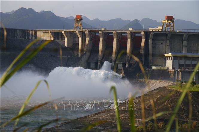
Meanwhile, by 4:00 p.m. yesterday (September 30), 20 hydropower reservoirs had released spillways to ensure flood prevention capacity and reduce flooding downstream. Specifically, Tuyen Quang Hydropower recorded the largest inflow of 6,985 m³/s at 9:30 a.m. and decreased to 5,550 m³/s at 1:00 p.m.; 8 deep spillways were opened to ensure project safety.
Tuyen Quang Hydropower Company closely monitors the development of floods, construction safety, flow to the reservoir, upstream and downstream water levels of the reservoir, and promptly reports to the Ministry of Agriculture and Environment (through the Department of Dyke Management and Disaster Prevention and Control) and relevant agencies as prescribed.
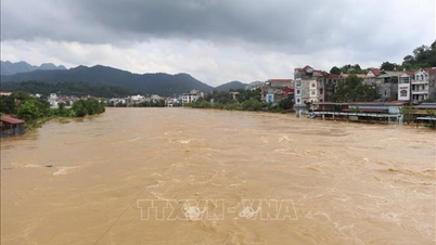
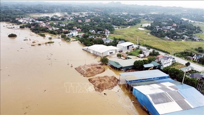
According to the National Center for Hydro-Meteorological Forecasting, from now until about 11:40 p.m. on October 1, the Northern provinces, Thanh Hoa, Nghe An and Ha Tinh will continue to have rain. Currently, floods on the Lo River (Tuyen Quang), Cau River, Thuong River (Bac Ninh), and Thai Binh River (Hai Phong) are rising. Due to the influence of upstream reservoirs and upstream floods, the water level in the downstream of the Red River at Hanoi station is rising, while the flood in the downstream of the Ca River (Nghe An) has little change.
Water levels at 7:00 p.m. on October 1 on the rivers were as follows: On the Lo River at Tuyen Quang station 26.08m, 0.08m above alarm level 3; On the Cau River at Dap Cau station 6.01m, 0.29m below alarm level 3; On the Thuong River at Phu Lang Thuong station 6.04m, 0.26m below alarm level 3; On the Thai Binh River at Pha Lai station 4.95m, 0.05m below alarm level 2; On the Red River at Ha Noi station 9.5m, at alarm level 1; On the Ca River at Nam Dan station 7.35m, 0.45m above alarm level 2.
It is forecasted that in the next 12 hours, flood on Lo River is likely to peak above alert level 3, then decrease; flood on Cau River and Thuong River is likely to peak at alert level 3, then decrease; flood on Thai Binh River continues to rise and is above alert level 2; flood downstream of Ca River continues to decrease and is above alert level 2.
In the next 12-24 hours, floods on Thai Binh River are likely to peak above alert level 2 and then decrease; floods on Lo River, Cau River, Thuong River continue to decrease and stay below alert level 3; Ca River continue to decrease and stay above alert level 2.
The National Center for Hydro-Meteorological Forecasting warned that in the next 24 hours, flood levels in the lower reaches of the Red River at Hanoi station will continue to rise and be above alert level 1; flood levels on the Luc Nam River (Bac Ninh) at Luc Nam station, and the Ma River (Thanh Hoa) at Giang station will continue to fall and be above alert level 1.
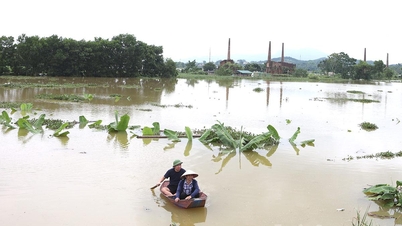
Flood warnings are in low-lying areas along rivers and urban areas in the Northern region, from Thanh Hoa to Nghe An; flash floods and landslides on steep slopes in the mountainous areas of the Northern region, from Thanh Hoa to Nghe An.
Flood risk warning level: Level 3. Flood warning on rivers causes flooding in low-lying areas along rivers, affecting activities such as waterway transportation, aquaculture, agricultural production, people's lives and socio-economic activities.
Source: https://baotintuc.vn/van-de-quan-tam/thuy-dien-tuyen-quang-dong-2-cua-xa-lu-tren-nhieu-song-o-bac-bo-dang-len-20251001220844962.htm

![[Photo] Hanoi morning of October 1: Prolonged flooding, people wade to work](https://vphoto.vietnam.vn/thumb/1200x675/vietnam/resource/IMAGE/2025/10/1/189be28938e3493fa26b2938efa2059e)
![[Photo] Keep your warehouse safe in all situations](https://vphoto.vietnam.vn/thumb/1200x675/vietnam/resource/IMAGE/2025/10/1/3eb4eceafe68497989865e7faa4e4d0e)

![[Photo] President of the Cuban National Assembly visits President Ho Chi Minh's Mausoleum](https://vphoto.vietnam.vn/thumb/1200x675/vietnam/resource/IMAGE/2025/10/1/39f1142310fc4dae9e3de4fcc9ac2ed0)


Comment (0)