
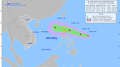
The tropical depression near the East Sea may strengthen into a storm in the next 24 hours. Source: Vietnam Disaster Monitoring System
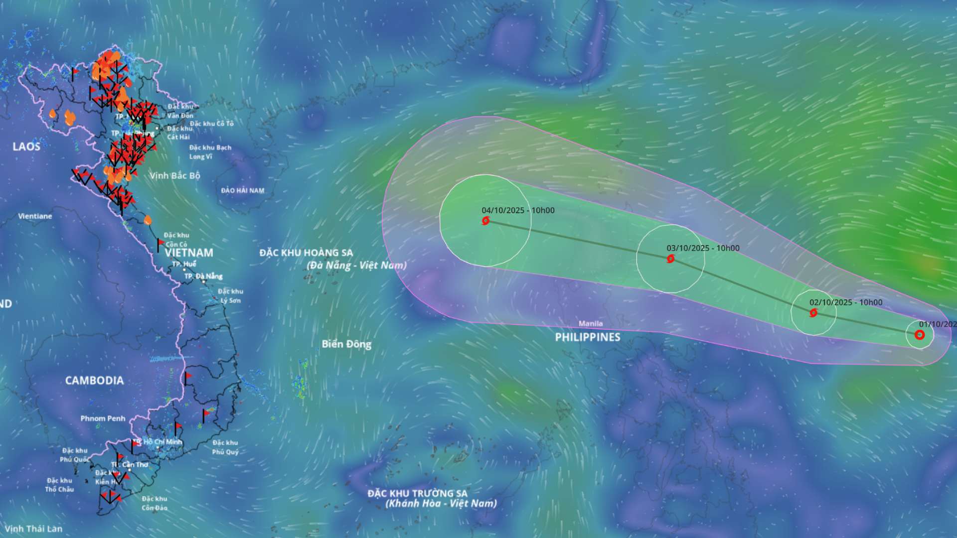
According to the National Center for Hydro-Meteorological Forecasting, at 10:00 a.m. on October 1, the center of the tropical depression was located at about 14.5 degrees north latitude; 131.4 degrees east longitude, in the sea east of Luzon Island (Philippines). The strongest wind near the center of the tropical depression was level 6-7 (39-61 km/h), gusting to level 9. Moving west-northwest at a speed of about 15 km/h.
It is forecasted that in the next 24 hours, the tropical depression will move west-northwest at a speed of about 15 km/h and is likely to strengthen into a storm.
At 10:00 a.m. on October 2, the center of the storm was at about 15.1 degrees north latitude; 128.3 degrees east longitude, in the sea east of Luzon Island (Philippines). The intensity was level 8, gusting to level 10.
Forecast in the next 48 hours , the storm continues to move west-northwest, speed about 20-25 km/h and has the potential to strengthen.
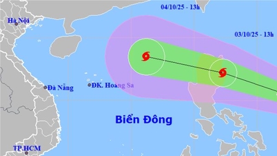
At 10:00 a.m. on October 3, the center of the storm was at about 16.8 degrees north latitude; 123.6 degrees east longitude, in the sea east of Luzon Island (Philippines). The intensity was level 9, gusting to level 11.
The danger zone is defined as the area located from latitude 14.5 degrees north to 21 degrees north, east of longitude 119. The disaster risk level is level 3 for the sea area east of the northern East Sea.
During the next 48 to 72 hours, the storm will move mainly in the west-northwest direction, traveling 25-30 km per hour, entering the East Sea and continuing to strengthen.
Regarding the impact of the tropical depression followed by the storm , from October 3, the sea area east of the northern East Sea will have winds gradually increasing to level 6 - 7; the area near the storm center will have strong winds of level 8, gusting to level 10, waves 2.5 - 4.5 m high. The sea will be rough.
During the period from October 4 to October 6, the northern East Sea area (including Hoang Sa archipelago) is likely to be affected by strong winds of level 10 - 11, gusting to level 14.
Vessels operating in the above mentioned dangerous areas are susceptible to the impact of storms, whirlwinds, strong winds and large waves.
According to Lao Dong Newspaper
Source: https://baotuyenquang.com.vn/xa-hoi/202510/du-bao-ap-thap-nhiet-doi-gan-bien-dong-sap-manh-len-thanh-bao-trong-24-gio-toi-ff07abf/

![[Photo] Keep your warehouse safe in all situations](https://vphoto.vietnam.vn/thumb/1200x675/vietnam/resource/IMAGE/2025/10/1/3eb4eceafe68497989865e7faa4e4d0e)
![[Photo] President of the Cuban National Assembly visits President Ho Chi Minh's Mausoleum](https://vphoto.vietnam.vn/thumb/1200x675/vietnam/resource/IMAGE/2025/10/1/39f1142310fc4dae9e3de4fcc9ac2ed0)

![[Photo] Hanoi morning of October 1: Prolonged flooding, people wade to work](https://vphoto.vietnam.vn/thumb/1200x675/vietnam/resource/IMAGE/2025/10/1/189be28938e3493fa26b2938efa2059e)


Comment (0)