
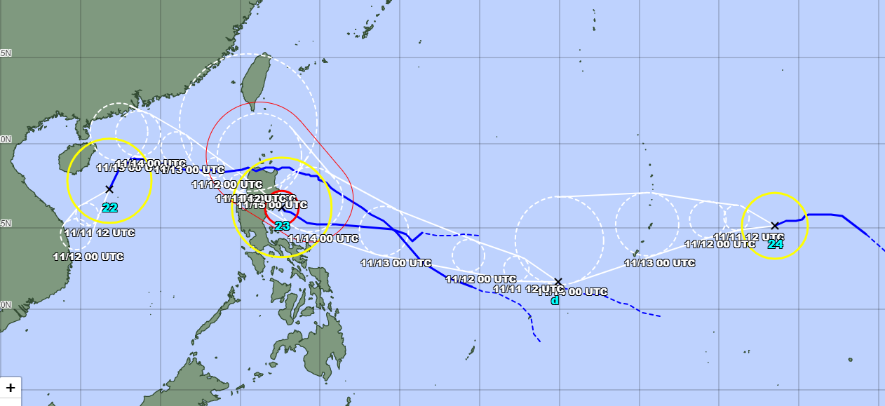
According to the latest storm bulletin from the meteorological agency, there are currently three storms active in the Northwest Pacific . Among them, Typhoon Yinxing is in the East Sea, Typhoon Toraji is near the East Sea, and Typhoon Man-yi is heading towards the Philippine Sea.
Latest news on Typhoon Yinxing
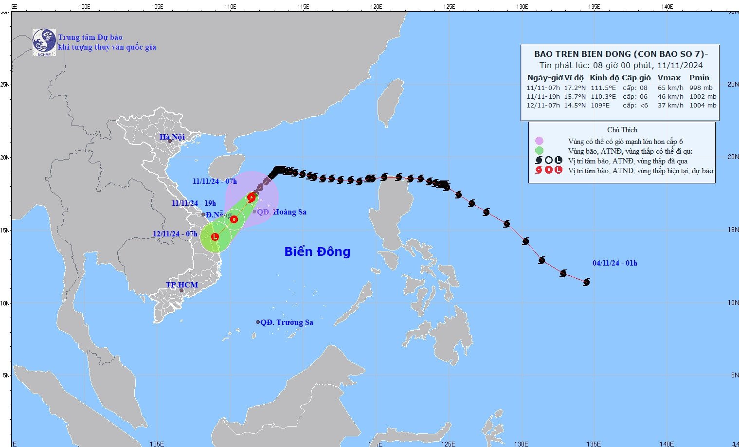
According to the National Center for Hydro-Meteorological Forecasting, at 7:00 a.m. on November 11, the center of storm Yinxing (storm No. 7) was located at about 17.2 degrees North latitude; 111.5 degrees East longitude, in the sea north of the Hoang Sa archipelago. The strongest wind near the center of the storm was level 8 (62-74 km/h), gusting to level 10. Moving southwest at a speed of about 15 km/h.
Storm forecast for the next 12 to 24 hours:
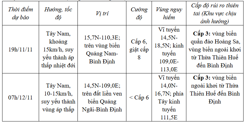
Storm No. 7 causes strong winds and big waves at sea: The sea area of Hoang Sa archipelago has strong winds of level 6-7, the area near the storm's eye has level 8, gusts of level 10, waves 2.0-4.0m high, the area near the storm's eye has 3.0-5.0m; rough seas.
From the afternoon of November 11, the sea off the coast of Thua Thien Hue to Binh Dinh will have winds gradually increasing to level 6-7, gusting to level 9, waves 2.0-4.0m high; rough seas.
Vessels operating in the above mentioned dangerous areas are susceptible to the impact of storms, whirlwinds, strong winds and large waves.
News of typhoon Toraji near the East Sea
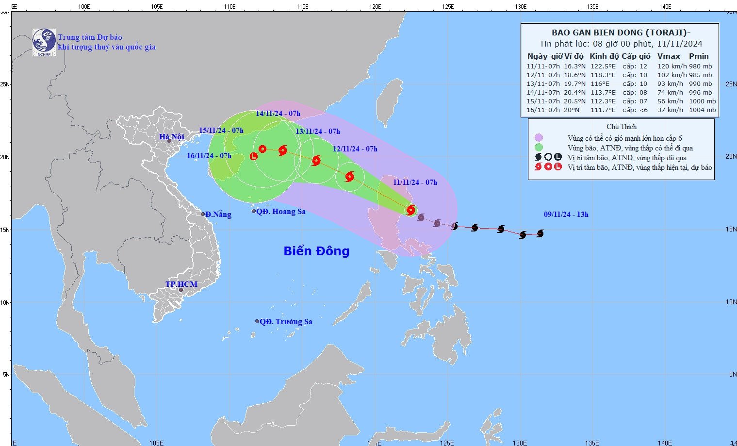
At 7:00 a.m. on November 11, the center of storm Toraji was at about 16.3 degrees North latitude; 122.5 degrees East longitude, in the sea east of Luzon Island (Philippines). The strongest wind near the center of the storm was level 12 (118-133 km/h), gusting to level 15. Moving in the West Northwest direction, speed about 20 km/h.
Storm forecast for the next 24 - 72 hours:
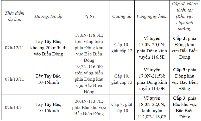
The meteorological agency forecasts that in the next 72-120 hours, the storm will move in a West-Northwest direction, then possibly change direction to West-Southwest, moving 5-10km per hour, and its intensity will continue to weaken.
Due to the impact of the storm, the sea in the East of the North East Sea gradually increased to level 6-7, then increased to level 8, near the eye of the storm level 9-10, gusting to level 12, waves 3.0-5.0m high, near the eye of the storm 5.0-7.0m; very rough seas.
Vessels operating in the above mentioned dangerous areas are susceptible to the impact of storms, whirlwinds, strong winds and large waves.
Typhoon Man-yi is active
The Japan Meteorological Agency has forecast Typhoon Man-yi with maximum winds near the center of the storm of 23 m/s.
Source: https://vietnamnet.vn/tin-bao-moi-nhat-11-11-3-bao-yinxing-toraji-man-yi-dang-hoat-dong-2340771.html
![[Photo] General Secretary To Lam, Secretary of the Central Military Commission attends the 12th Party Congress of the Army](https://vphoto.vietnam.vn/thumb/1200x675/vietnam/resource/IMAGE/2025/9/30/9b63aaa37ddb472ead84e3870a8ae825)
![[Photo] The 1st Congress of Phu Tho Provincial Party Committee, term 2025-2030](https://vphoto.vietnam.vn/thumb/1200x675/vietnam/resource/IMAGE/2025/9/30/1507da06216649bba8a1ce6251816820)
![[Photo] President Luong Cuong receives President of the Cuban National Assembly Esteban Lazo Hernandez](https://vphoto.vietnam.vn/thumb/1200x675/vietnam/resource/IMAGE/2025/9/30/4d38932911c24f6ea1936252bd5427fa)

![[Photo] Solemn opening of the 12th Military Party Congress for the 2025-2030 term](https://vphoto.vietnam.vn/thumb/1200x675/vietnam/resource/IMAGE/2025/9/30/2cd383b3130d41a1a4b5ace0d5eb989d)
![[Photo] Panorama of the cable-stayed bridge, the final bottleneck of the Ben Luc-Long Thanh expressway](https://vphoto.vietnam.vn/thumb/1200x675/vietnam/resource/IMAGE/2025/9/30/391fdf21025541d6b2f092e49a17243f)


Comment (0)