
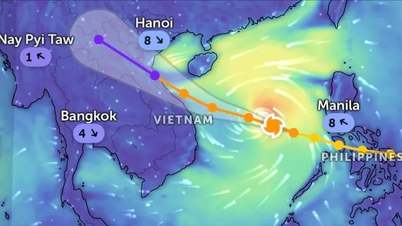
According to the Joint Typhoon Warning Center (USA), this morning, September 25, Vietnam time, the eye of storm Ragasa (storm No. 9) passed north of Leizhou peninsula (China), swept along the southern coast of Guangxi province (China) towards Mong Cai area of Vietnam.
 according to US data. Source: Z.E")
According to the National Center for Hydro-Meteorological Forecasting, at 7:00 a.m., the storm center was at about 21.5 degrees North latitude - 108.9 degrees East longitude, about 100km east of Mong Cai ( Quang Ninh ). The strongest wind speed decreased to only level 8 (62 - 74km/h), gusting to level 10. In the next 3 hours, the storm will continue to move west at a speed of about 20km/h.

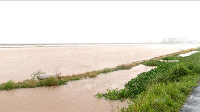
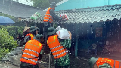
According to data sent back from monitoring stations from the sea and islands, due to the impact of the storm, in Bach Long Vi special zone, strong winds of level 7, gusting to level 8 were recorded. It is forecasted that on September 25, the storm circulation will continue to cause strong winds in the northern Gulf of Tonkin, especially from Quang Ninh to Hai Phong .
This morning, Hanoi and some places in the North still have light rain, but the weather is showing signs of worsening. Some places in Lao Cai, Tuyen Quang, Thai Nguyen, Lang Son, Quang Ninh... have had rain due to the circulation before the storm.

According to Mr. Hoang Phuc Lam, Deputy Director of the National Center for Hydro-Meteorological Forecasting, from around noon today, Hanoi and the Northern Delta will have heavier rain.
The National Center for Hydro-Meteorological Forecasting said that by 4 p.m. today, the storm will move westward at a speed of about 20 km/hour, making landfall in the northeastern region of the North (Quang Ninh - Lang Son) and weakening into a tropical depression. At this time, the wind near the center of the depression will only be at level 6, gusting to level 8.
Source: https://www.sggp.org.vn/bao-so-9-da-suy-yeu-con-cap-8-post814572.html


![[Photo] Prime Minister Pham Minh Chinh attends the 1st Hai Phong City Party Congress](https://vphoto.vietnam.vn/thumb/1200x675/vietnam/resource/IMAGE/2025/9/27/676f179ddf8c4b4c84b4cfc8f28a9550)


![[Photo] Soldiers guard the fire and protect the forest](https://vphoto.vietnam.vn/thumb/1200x675/vietnam/resource/IMAGE/2025/9/27/7cab6a2afcf543558a98f4d87e9aaf95)


Comment (0)