
According to a quick report from Tay Yen Tu commune, from 2:00 p.m. to 5:00 p.m. on September 29, there was heavy rain in the commune, with rainfall reaching about 150mm; floods on rivers and streams rose, reaching up to 3m in some places. The entire commune had 14/16 culverts flooded from 0.3 - 1.5m deep, causing traffic difficulties.
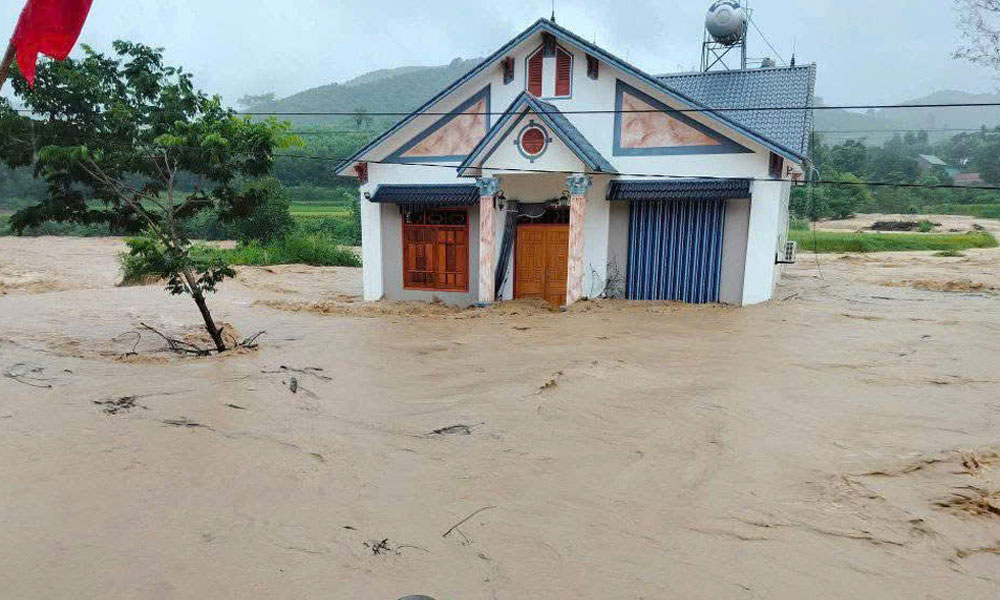 |
A house of a resident of Van Son commune was deeply flooded due to heavy rain and floods. |
Through inspection, landslides from previous storms continue to pose a risk of landslides. Of which, Provincial Road 291 has 1 landslide at Km18+500 (from Doan Ket village to Dong Ri village); Provincial Road 293 has 2 landslides (from Thanh Ha village to Duong Huu commune); DH93C road connecting Son Dong commune to Tuan Dao commune, Tay Yen Tu has 1 landslide that completely buried the road surface.
In Van Son commune, heavy rains flooded many traffic and irrigation works in the villages of San 3, Kha, and Na Vang. According to local leaders, families at risk of being affected by landslides in the area were assisted by the Commune Civil Defense Command to move their belongings and evacuate people from dangerous areas.
As of 5 p.m. on September 29, the entire commune had nearly 60 hectares of rice and crops flooded. Many roads within villages and fields had landslides. In particular, provincial road 291D, the section through Ga village to Dong Cao, was impassable to cars due to a landslide of about 5,000 cubic meters. The locality is coordinating with the authorities to mobilize human resources and machinery to fix the above problem.
In Yen Dinh, Tuan Dao, Dai Son communes, the Commune Civil Defense Command established working groups to inspect the response activities to storm No. 10 in the area. After checking, Yen Dinh commune has 20 households with 65 people in areas at risk of landslides that have been evacuated to safety.
Currently, the rain continues to fall in the communes, so the exact damage has not been determined yet, but it is estimated that dozens of hectares of rice and crops have been flooded. At landslide and flood points, warning signs have been placed warning of dangerous areas, prohibiting people and vehicles from passing through. In the face of complicated rain and flood situations, localities have simultaneously deployed plans to be on duty and respond to storms and floods 24/24 hours.
Comrade Nguyen Ngoc Son, Chairman of Tuan Dao Commune People's Committee, said: "From the afternoon and evening of September 29, the police, military and functional forces of the commune focused on supporting households to transport their assets to safe places, to prevent flooding. The Commune Civil Defense Command and the villages activated the plan to deploy 100% of their troops, prepared boats, life jackets, flashlights and other means to be ready with the plan to deal with deep flooding due to rising floods at night."
 |
Tuan Dao commune authorities help people move their properties to prevent flooding. |
According to the Bac Ninh Province Hydrometeorological Station, the water level on the Luc Nam River is at a high level. At noon on September 29, the Cam Dan Hydrological Station reached alert level 1, and is forecast to reach alert level 2. Communes along the river, low-lying areas such as Dai Son, Tuan Dao, Son Dong, Yen Dinh, Son Hai, Bien Son... are likely to experience local landslides on small streams, places with steep terrain, and taluy on traffic routes.
Therefore, the People's Committees of communes and wards strictly implement the work of natural disaster prevention and control; arrange forces to be on duty regularly, proactively grasp developments and situations, and take quick and timely measures to overcome incidents caused by floods according to the motto "4 on-site".
Source: https://baobacninhtv.vn/bac-ninh-cac-dia-phuong-bo-tri-luc-luong-san-sang-ung-pho-su-co-do-mua-lu-postid427629.bbg

![[Photo] Students of Binh Minh Primary School enjoy the full moon festival, receiving the joys of childhood](https://vphoto.vietnam.vn/thumb/1200x675/vietnam/resource/IMAGE/2025/10/3/8cf8abef22fe4471be400a818912cb85)


![[Photo] Prime Minister Pham Minh Chinh chairs meeting to deploy overcoming consequences of storm No. 10](https://vphoto.vietnam.vn/thumb/1200x675/vietnam/resource/IMAGE/2025/10/3/544f420dcc844463898fcbef46247d16)


![[Infographic] What are the growth targets of Dong Nai province in the first 9 months of 2025?](https://vphoto.vietnam.vn/thumb/402x226/vietnam/resource/IMAGE/2025/10/3/45f9330556eb4c6a88b098a6624d7e5b)


Comment (0)