
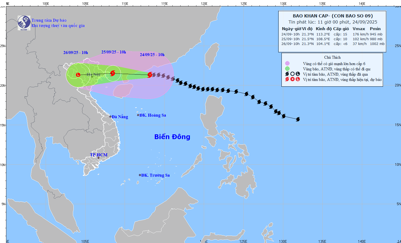
According to the National Center for Hydro-Meteorological Forecasting, at 10:00 on September 24, the center of the storm was at about 21.3°N; 113.2°E, about 570 km east of Mong Cai ( Quang Ninh ). The strongest wind was level 15 (167 - 183 km/h), gusting over level 17. The storm moved in the West Northwest direction at a speed of about 20 km/h.
Forecast, by 10:00 on September 25, the storm will move West Northwest at 20 km/h, gradually weakening. Location at 21.5°N–108.5°E, on the coastal area of Quang Ninh – Hai Phong . Strong wind force level 10, gust level 12. Dangerous area: North of latitude 19.0°N; West of longitude 116.0°E. Disaster risk level: level 4 in the Northwestern sea of the East Sea; level 3 in the North Gulf of Tonkin and the Northeastern coast.
At 10:00 on September 26, the storm moved west at about 20 km/h, weakened into a tropical depression, then a low pressure area. Location at 21.3°N–104.1°E, on the mainland of the Northwest region of the North. Intensity below level 6. Dangerous area: North of latitude 19.5°N; West of longitude 110.0°E. Disaster risk level: level 3 for the North Gulf of Tonkin and the Northeast coast.
Due to the impact of the storm, the Northwestern part of the East Sea has strong winds of level 10-12, near the center of the storm level 13-15, gusting over level 17. Waves over 10 m high, rough seas.
The Northeastern Gulf of Tonkin (including Bach Long Vi) has strong winds of level 6-7, gusts of level 9. From the night of September 24, the North Gulf of Tonkin (Bach Long Vi, Van Don, Co To, Cat Hai, Hon Dau) has winds gradually increasing to level 7-8, waves 2-4 m high; the area near the storm center has winds of level 9-11, gusts of level 13, waves 3-5 m high, and very rough seas.
Quang Ninh coastal area has storm surge of 0.4 - 0.6 m. Boats anchored along the shore and aquaculture areas are strongly affected by wind, big waves and rising sea levels.
On land, from early morning on September 25, the coastal area from Quang Ninh to Hung Yen will see winds gradually increase to level 6-7, near the storm center level 8-9, gusting to level 11. Deep inland in the Northeast, winds will be level 5, in some places level 6, gusting to level 7-8.
From the night of September 24 to the end of the night of September 26, the North, Thanh Hoa and Nghe An will have heavy to very heavy rain, with rainfall ranging from 100 to 250 mm, and in some places over 400 mm. There is a high risk of flooding in low-lying areas, flash floods on small rivers and streams, and landslides in mountainous areas.
Due to the wide storm circulation, be on guard for thunderstorms, tornadoes and strong gusts of wind before and during the storm's landfall.
Source: https://baotintuc.vn/xa-hoi/bao-ragasa-giat-tren-cap-17-huong-vao-quang-ninh-hai-phong-20250924111531387.htm
![[Photo] Prime Minister Pham Minh Chinh attends the groundbreaking ceremony of two key projects in Hai Phong city](https://vphoto.vietnam.vn/thumb/1200x675/vietnam/resource/IMAGE/2025/9/27/6adba56d5d94403093a074ac6496ec9d)


Comment (0)