
 |
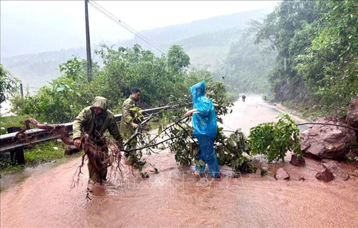
| A traffic point in A Lieng village, Ta Rut commune, Quang Tri province had a landslide, rocks fell onto the road. Photo: VNA. |
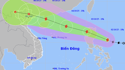
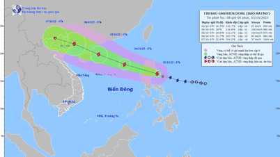
Speaking to the press on the morning of September 29, Mr. Mai Van Khiem, Director of the National Center for Hydro-Meteorological Forecasting, said that storm No. 10 has now weakened to about level 9, gusting to level 11, and it is forecasted that around 10 a.m. on September 29, storm No. 10 will weaken into a tropical depression, then continue to move further inland. Although storm No. 10 will weaken, the impacts of storm No. 10's circulation will still be strong.
Mr. Mai Van Khiem noted that heavy rains will continue on September 29 in the provinces of Nghe An, Thanh Hoa, and Ha Tinh . In addition, heavy rains will also spread to the provinces of the Northern Delta and midlands, with rainfall forecasted to be around 150-250mm. Some localized areas may reach over 350mm.
Along with that, the flood situation on the river systems in the North is also noteworthy, the flood forecast on the river systems in the North is above alert level 2, alert level 3. Notably, the flood on the Kien Giang river system in Quang Tri on the night of September 28 peaked, exceeding alert level 3 and is currently receding. However, the flooding situation in the riverside areas in this area continues to last.
In particular, the flood on the Ha Tinh river system is rising rapidly, forecast to exceed alert level 3 on the morning of September 29. The risk of flooding in the areas along the Ngan Sau and Ngan Pho rivers in Ha Tinh today and in the coming days is high.
In addition, a notable risk is flash floods and landslides. With rainfall forecast to reach several hundred mm from September 29 to September 30, flash floods and landslides may occur in the mountainous areas of the West of the North Central provinces, as well as the midland and mountainous areas of the North on September 29 and the coming days.
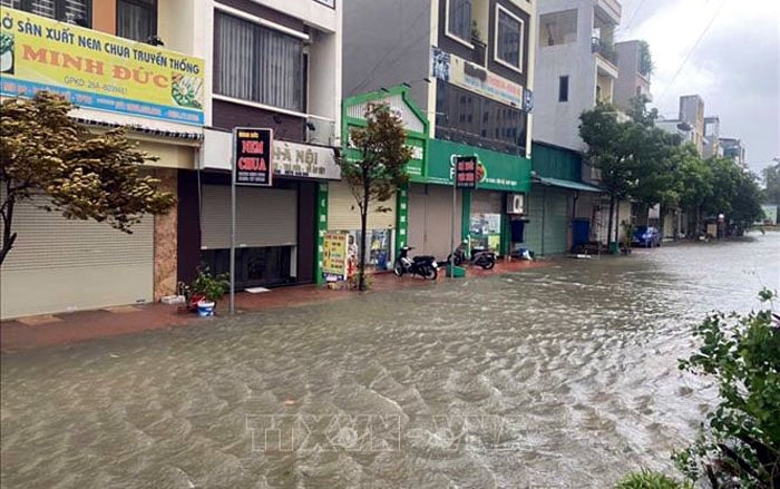 |
| Lobby area of Tan Thanh 1 apartment building, Hac Thanh ward, Thanh Hoa , water continues to rise. |
According to the forecast of the National Center for Hydro-Meteorological Forecasting, by 7:00 p.m. on September 29, the storm will move in the West-Northwest direction at a speed of 20-25 km/h, moving deep into the mainland, gradually weakening into a tropical depression, then a low pressure area, the storm's location is at 19.9N-102.3E, in the Upper Laos region, the storm intensity is below level 6, the dangerous area is the latitude area 17.0N-20.0N; west of longitude 108.0E, natural disaster risk level 3, the affected area is the sea area from Thanh Hoa to Quang Tri (including Hon Ngu island, Con Co special zone); Northern Gulf of Tonkin (including Bach Long Vi special zone, Van Don, Co To, Cat Hai and Hon Dau island).
Due to the influence of storm No. 10, the sea area from Thanh Hoa to Northern Quang Tri (Hon Ngu, Con Co) has strong winds of level 6-7, near the storm center level 8-9, gusts of level 12; waves of 3-5m, rough seas. Northern Bac Bo Gulf (Bach Long Vi, Van Don, Co To, Cat Hai, Hon Dau) has strong winds of level 6-7, gusts of level 8-9; waves of 2-4m, rough seas.
From September 29 to September 30, the Northern Delta, Phu Tho, the southern part of Son La, Lao Cai provinces and the provinces from Thanh Hoa to Ha Tinh will have heavy to very heavy rain with total rainfall ranging from 100-200mm, locally over 350mm. Warning of the risk of heavy rain over 200mm/3 hours. Other places in the North will have moderate rain, heavy rain, and very heavy rain in some places, with total rainfall ranging from 70-120mm, locally over 200mm.
The National Center for Hydro-Meteorological Forecasting said that from 8:40 a.m. to 1:40 p.m., the provinces and cities of Lao Cai, Son La, Phu Tho, Thanh Hoa to Da Nang city will continue to have rain; there is a risk of flash floods on small rivers and streams, and landslides on steep slopes in the above provinces and cities.
Source: https://baothainguyen.vn/tin-moi/202509/bao-so-10-se-suy-yeu-thanh-ap-thap-nhiet-doi-gay-mua-lu-nhieu-noi-bfa50c0/

![[Photo] Binh Trieu 1 Bridge has been completed, raised by 1.1m, and will open to traffic at the end of November.](https://vphoto.vietnam.vn/thumb/1200x675/vietnam/resource/IMAGE/2025/10/2/a6549e2a3b5848a1ba76a1ded6141fae)


Comment (0)