

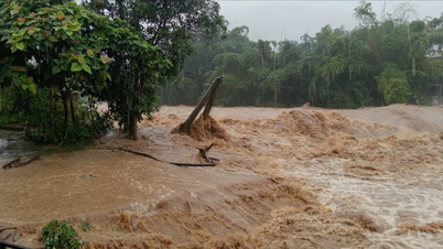
Provinces from Nghe An to Da Nang have had heavy rain, some places with very heavy rain over 170 mm.
At 10:00 a.m. on August 30, the storm center was at 17.9° North latitude - 107.5° East longitude ( Ha Tinh - Quang Tri sea), about 120 km east of North Quang Tri. Strong winds level 8 (62-74 km/h), gusts level 10-11. Moving West Northwest at 20-25 km/h.
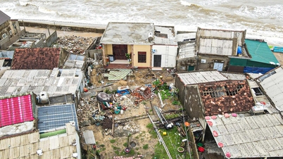
Storm No. 6 has strong winds of level 8, gusts of 10-11, which can cause trees to fall, roofs to blow off, and is dangerous for boats and rafts. The sea is very rough.
Forecast for the next 12-24 hours (forecast at 11am), by 10pm on August 30, the storm will move West-Northwest at 20km/h, make landfall in Ha Tinh - North Quang Tri , weaken into a tropical depression. Location 18.1° North latitude - 105.3° East longitude (Vietnam - Laos border). Wind level 6, gust 8.
At 10:00 a.m. on August 31, the storm continued to move West-Northwest at 20 km/h, entered Central Laos, and weakened into a low pressure area (< level 6). Danger zone: 16.5°–20° North latitude, West of 110° East longitude.
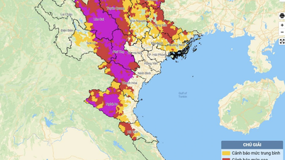
Disaster risk level: level 3, Thanh Hoa sea area - Hue city (including Hon Ngu, Con Co).
According to the National Center for Hydro-Meteorological Forecasting, at sea: Thanh Hoa - Hue city (Hon Ngu, Con Co) wind level 6-7, near the storm center level 8, gust 10; waves 2-4m, near the storm center 3-5m, rough sea. Northern Gulf of Tonkin wind level 6-7, gust 9; waves 2-4m.
Rising water: Nghe An – Hue city 0.2-0.4m high. Warning, very dangerous for boats, cages, aquaculture areas, coastal works.
On land: Nghe An - Quang Tri wind level 6, gust 8; Ha Tinh - North Quang Tri level 6-7, near storm center level 8, gust 10.
From noon on August 30 to the end of August 31: Thanh Hoa - Hue city heavy to very heavy rain, 100-250 mm, locally over 400 mm.
The Northern Midlands and Delta have moderate to heavy rain, commonly 50-120 mm, in some places over 250 mm.
Source: https://baolaocai.vn/bao-so-6-co-gio-manh-cap-8-giat-cap-1011-di-chuyen-theo-huong-tay-tay-bac-post880878.html


![[Photo] General Secretary To Lam receives US Ambassador to Vietnam Marc Knapper](https://vphoto.vietnam.vn/thumb/1200x675/vietnam/resource/IMAGE/2025/9/29/c8fd0761aa184da7814aee57d87c49b3)
![[Photo] General Secretary To Lam attends the ceremony to celebrate the 80th anniversary of the post and telecommunications sector and the 66th anniversary of the science and technology sector.](https://vphoto.vietnam.vn/thumb/1200x675/vietnam/resource/IMAGE/2025/9/29/8e86b39b8fe44121a2b14a031f4cef46)
![[Photo] Many streets in Hanoi were flooded due to the effects of storm Bualoi](https://vphoto.vietnam.vn/thumb/1200x675/vietnam/resource/IMAGE/2025/9/29/18b658aa0fa2495c927ade4bbe0096df)
![[Photo] National Assembly Chairman Tran Thanh Man chairs the 8th Conference of full-time National Assembly deputies](https://vphoto.vietnam.vn/thumb/1200x675/vietnam/resource/IMAGE/2025/9/29/2c21459bc38d44ffaacd679ab9a0477c)


![[Infographics] The 30th Bay Nui Bull Racing Festival for the An Giang Television Cup](https://vphoto.vietnam.vn/thumb/402x226/vietnam/resource/IMAGE/2025/9/10/b6a3f19f8764496199fee96d228cc1b5)


![[Infographics] Time, location, content of the 1st Congress of An Giang Provincial Party Committee, term 2025 - 2030](https://vphoto.vietnam.vn/thumb/402x226/vietnam/resource/IMAGE/2025/9/30/fed466586ad84c3ebea914be993018ca)


Comment (0)