
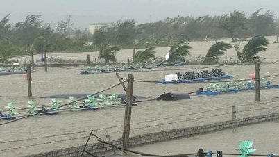
Around October 27, the center of storm No. 6 (storm Tra Mi) was in the coastal waters of the Central Central provinces and remained in this area for about 24 hours, with intensity of level 9-10 and constantly changing direction. From Ha Tinh to Quang Ngai, there was prolonged heavy rain.
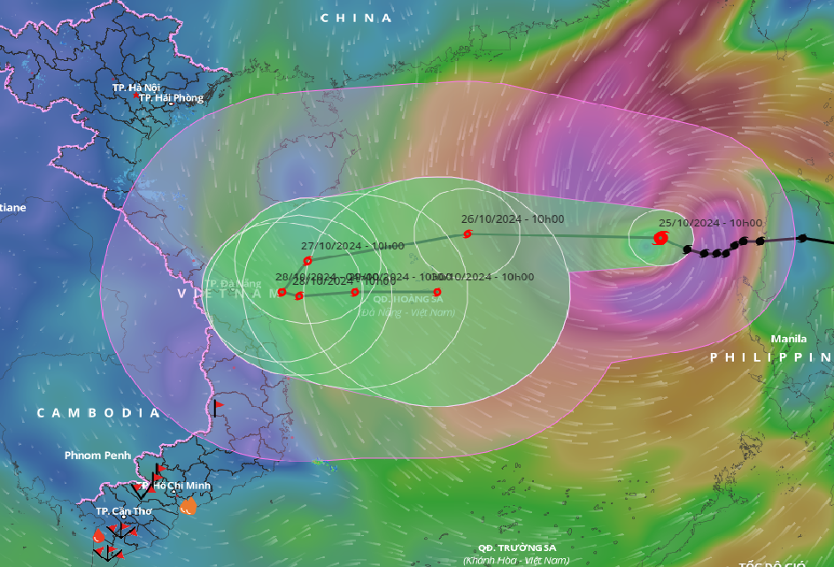
According to the National Center for Hydro-Meteorological Forecasting, as of 7:00 p.m. tonight (October 25), the center of storm No. 6 (storm Tra Mi) is located in the eastern sea of the North East Sea, about 410 km east-northeast of Hoang Sa archipelago. The strongest wind near the center of the storm is level 10 (89-102 km/h), gusting to level 12. Moving westward, at a speed of about 20 km/h.
It is forecasted that in the next 24 hours, storm No. 6 will maintain its direction and speed of movement, reaching its maximum intensity of level 11-12, gusting to level 15. By 7:00 p.m. tomorrow night (October 26), the storm's center will be in the sea north of Hoang Sa archipelago.
At 7 p.m. on October 27, the storm changed direction, moving west-southwest at a speed of about 15 km/h. The center of the storm was located in the coastal waters of the Central Central provinces, the intensity decreased to level 10, gusting to level 12.
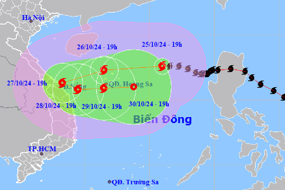
In the next 24 hours, the storm will move to the South-Southwest, then East-Southeast at a speed of 5-10km/h. By 7pm on October 28, the center of storm No. 6 was still over the coastal waters of the Central Central provinces with a further decrease in intensity, to level 9, gusting to level 11.
From the next 72 to 120 hours, the storm will move mainly to the East at 5-10km per hour, and its intensity will continue to weaken.
Due to the influence of storm No. 6, in the northern East Sea, strong winds of level 8-9, near the storm's eye level 10-12 (89-133km/h), gusts of level 15, waves 5-7m high, near the storm's eye 7-9m; rough seas.
From early morning on October 27, the sea areas of the provinces from Quang Binh to Quang Ngai (including Con Co Island, Cu Lao Cham, Ly Son) have winds gradually increasing to level 6-7, then increasing to level 8-9, the area near the storm center will have level 10-11, gusting to level 14, waves 3-5m high, the area near the storm center will have 5-7m; the sea will be very rough.
At the same time, the meteorological agency warned that from the morning of October 27, coastal areas from Quang Tri to Quang Nam provinces may experience storm surges of 0.4-0.6m high.
Ships and boats operating in the above-mentioned dangerous areas (especially in the Hoang Sa island district) and coastal areas from Quang Binh to Quang Ngai are likely to be affected by storms, whirlwinds, strong winds, and big waves.
High risk of landslides of sea dikes and embankments along the coast of provinces from Quang Tri to Quang Nam due to the impact of big waves and storm surges.
On land, from the morning of October 27, coastal areas from Quang Binh to Quang Ngai will have winds gradually increasing to level 6-7, near the storm center level 8-9, gusting to level 11.
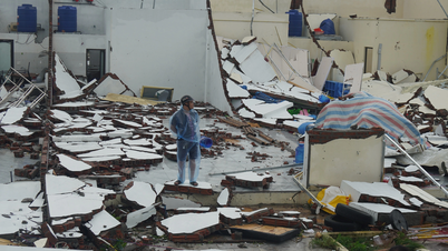
Due to the influence of storm No. 6, from the evening and night of October 26 to October 28, in the area from Quang Tri to Quang Ngai, there will be heavy to very heavy rain with total rainfall ranging from 300-500mm, locally over 700mm.
Warning of the risk of local heavy rain (>100mm/3 hours). Ha Tinh - Quang Binh, Binh Dinh and the northern Central Highlands will have heavy rain, some places will have very heavy rain with total rainfall ranging from 100-200mm, some places over 300mm.
The development of storm No. 6 is still very complicated and may change. People should pay attention to updates in the next storm bulletins.
Storm No. 6 is likely to approach the Central coast, with heavy rain focusing on 5 provinces.
Why does storm number 6 have a 'strange' direction?
Source: https://vietnamnet.vn/bao-so-6-bao-tra-mi-o-ven-bo-bien-trung-trung-bo-hon-24-gio-doi-huong-3-lan-2335635.html
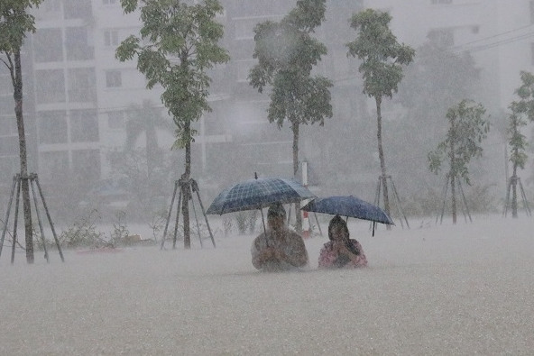
![[Photo] Many streets in Hanoi were flooded due to the effects of storm Bualoi](https://vphoto.vietnam.vn/thumb/1200x675/vietnam/resource/IMAGE/2025/9/29/18b658aa0fa2495c927ade4bbe0096df)
![[Photo] General Secretary To Lam receives US Ambassador to Vietnam Marc Knapper](https://vphoto.vietnam.vn/thumb/1200x675/vietnam/resource/IMAGE/2025/9/29/c8fd0761aa184da7814aee57d87c49b3)
![[Photo] National Assembly Chairman Tran Thanh Man chairs the 8th Conference of full-time National Assembly deputies](https://vphoto.vietnam.vn/thumb/1200x675/vietnam/resource/IMAGE/2025/9/29/2c21459bc38d44ffaacd679ab9a0477c)
![[Photo] General Secretary To Lam chairs the meeting of the Central Steering Committee on preventing and combating corruption, waste and negativity](https://vphoto.vietnam.vn/thumb/1200x675/vietnam/resource/IMAGE/2025/9/29/fb2a8712315d4213a16322588c57b975)

![[Photo] General Secretary To Lam attends the ceremony to celebrate the 80th anniversary of the post and telecommunications sector and the 66th anniversary of the science and technology sector.](https://vphoto.vietnam.vn/thumb/1200x675/vietnam/resource/IMAGE/2025/9/29/8e86b39b8fe44121a2b14a031f4cef46)


Comment (0)