

Path of storm BUALOI
On the afternoon of September 24, commenting on storm BUALOI, Deputy Director of the National Center for Hydro-Meteorological Forecasting Hoang Phuc Lam said that a new storm has formed east of the Philippines, the 20th storm in the Northwest Pacific region, with the international name BUALOI. It is expected that in the next 2 days the storm will enter the East Sea, most likely becoming storm number 10. This storm has just formed, and is currently at level 8.
Currently, forecasts on the development of storm No. 10 are still very scattered. Forecasts from Europe and Japan predict that storm No. 10 will move north, towards the North or the southern region of China. However, forecasts from the US predict that the storm will move into the Central region of Vietnam (focusing on the provinces from Ha Tinh to Quang Ngai).
According to the National Center for Hydro-Meteorological Forecasting, the possibility of the storm moving into the Central region is the scenario with the highest probability because during this period, according to the law, the storm will move into the Central region. However, the possibility of strengthening to the level of a super storm or a storm stronger than level 13 is not high.
According to Mr. Hoang Phuc Lam, current forecasts show that the maximum intensity of storm BUALOI is not as strong as storm RAGASA. However, to have a more accurate forecast, we need to wait until the storm is stronger, has a stable cloud organization, and a complete storm structure. The center will continue to monitor and update the development of storm BUALOI and around September 25 will issue storm information near the East Sea.
Specifically, at 7:00 a.m. on September 24, the center of storm BUALOI was at about 9.8°N – 132.4°E. The strongest wind near the center was level 9 (75–88 km/h), gusting to level 11. The storm moved west-northwest at a speed of about 15 km/h. It is forecasted that around the night of September 26, the storm will enter the East Sea and become storm number 10 in 2025.
Forecast by 7am on September 27, storm BUALOI will move into the East Sea with intensity of level 11, gusting to level 14. Disaster risk level: Level 3 in the eastern sea area of the North and Central East Sea.
Development warning (next 72–120 hours), the storm continues to move rapidly in the west-northwest direction, at a speed of 20–25 km/h, and may strengthen.
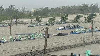
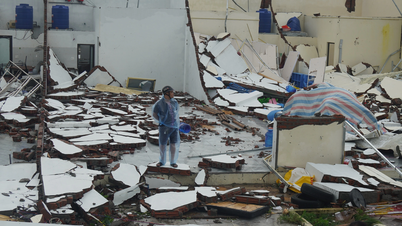
Due to the impact of the storm, from the evening and night of September 26, the northeastern and central East Sea areas will have winds gradually increasing to level 6-7, then increasing to level 8-9. The area near the storm center will have winds of level 10-11, gusting to level 14, waves 5-7m high, and rough seas. Dangerous for ships operating in the northern and central East Sea areas.
Thu Cuc
Source: https://baochinhphu.vn/bien-dong-sap-don-bao-so-10-du-bao-cuong-do-cuc-dai-khong-manh-nhu-bao-so-9-102250924154555256.htm
![[Photo] Many streets in Hanoi were flooded due to the effects of storm Bualoi](https://vphoto.vietnam.vn/thumb/1200x675/vietnam/resource/IMAGE/2025/9/29/18b658aa0fa2495c927ade4bbe0096df)
![[Photo] General Secretary To Lam attends the ceremony to celebrate the 80th anniversary of the post and telecommunications sector and the 66th anniversary of the science and technology sector.](https://vphoto.vietnam.vn/thumb/1200x675/vietnam/resource/IMAGE/2025/9/29/8e86b39b8fe44121a2b14a031f4cef46)
![[Photo] General Secretary To Lam receives US Ambassador to Vietnam Marc Knapper](https://vphoto.vietnam.vn/thumb/1200x675/vietnam/resource/IMAGE/2025/9/29/c8fd0761aa184da7814aee57d87c49b3)

![[Photo] General Secretary To Lam chairs the meeting of the Central Steering Committee on preventing and combating corruption, waste and negativity](https://vphoto.vietnam.vn/thumb/1200x675/vietnam/resource/IMAGE/2025/9/29/fb2a8712315d4213a16322588c57b975)
![[Photo] National Assembly Chairman Tran Thanh Man chairs the 8th Conference of full-time National Assembly deputies](https://vphoto.vietnam.vn/thumb/1200x675/vietnam/resource/IMAGE/2025/9/29/2c21459bc38d44ffaacd679ab9a0477c)


Comment (0)