
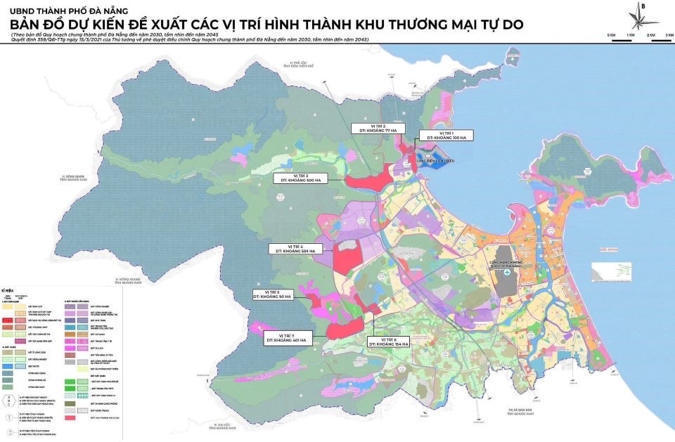
Accordingly, the study area for local adjustment of the general planning belongs to Hai Van and Lien Chieu wards, Ba Na and Hoa Vang communes, Da Nang city. The area has a total adjusted area of about 1,881 hectares.
Location 1 is located in Hai Van ward and has a specific scope: the North borders the foot of Hai Van pass and the road connecting Lien Chieu seaport; the South borders Cu De river; the East borders Kim Lien bay; the West borders Lien Chieu industrial park. Area of about 100ha.
Location 2 is located in Hai Van ward and has a specific scope: the North borders the Lang Van tourist complex and resort urban area and the Lien Chieu communal house area; the South borders the Lien Chieu Industrial Park and the residential area behind Kim Lien Bay; the East borders the residential area and Lien Chieu Industrial Park; the West borders the Lang Van tourist complex and resort urban area project. Area of about 77 hectares.
Location 3 is located in Hai Van ward and has a specific scope: the North borders the ADB Bac Thuy Tu - Pho Nam route; the South borders the Cu De river; the East borders the Nam Hai Van bypass; the West borders An Dinh village. Area of about 500 hectares.
Location 4 is located in Lien Chieu ward, Ba Na commune and has a specific scope: the North borders Hoa Ninh cemetery and the Western belt road; the South borders Dong Son and Son Phuoc villages; the East borders Son Phuoc village and DT602 road; the West borders the Western belt road. Area of about 599ha.
Location 5 is located in Ba Na commune and has a specific scope: the North borders the water surface (Suoi Mo); the South borders the water surface (Suoi Lanh); the East borders the water surface (Suoi Mo) and tourism service land; the West borders the production forest land. Area of about 90ha.
Location 6 is located in Ba Na commune and has a specific scope: North borders An Son village; South borders Dieu Phong village and Truoc Dong village; East borders Dieu Phong village and Truoc Dong village; West borders Hoi Phuoc village, Hoang Van Thai street and Dieu Phong village. Area of about 154ha.
Location 7 is located in Ba Na commune and Hoa Vang commune with the following scope: North borders Ba Na golf course expansion project and Dieu Phong village; South borders Dong Lam village and Hoa Hai village; East borders Dieu Phong village; West borders Phu Tuc village. Area of about 401ha.
Based on the above adjustment of the locations for establishing the Da Nang Free Trade Zone, the general planning of Da Nang city to 2030, with a vision to 2045 (Decision No. 359/QD-TTg of the Prime Minister ) is locally adjusted as follows:
Urban construction land by 2030 is about 30,400 hectares, a decrease of about 1,307 hectares, accounting for about 30.84% of the land area. Other land is about 66,356 hectares, a decrease of about 483 hectares. At the same time, adjust and supplement point d to Clause 5, Article 1 of Decision No. 359/QD-TTg with the content: free trade zone land is about 1,790 hectares.
The City People's Committee assigned the Management Board of the High-Tech Park and Industrial Parks of Da Nang to synchronously deploy the contents of local adjustments to the general planning into the approved zoning plans; ensuring consistency and continuity between planning levels according to current regulations, including ensuring suitability with the terrain, geology, accessibility, landscape and environment in the area.
Relevant departments, branches, sectors and localities shall base on the decision to locally adjust the master plan to synchronously deploy plans, programs, projects and other related work contents.
The Decision takes effect from August 22, 2025.
Source: https://baodanang.vn/dieu-chinh-cac-vi-tri-thanh-lap-khu-thuong-mai-tu-do-da-nang-3300394.html


![[Photo] Binh Trieu 1 Bridge has been completed, raised by 1.1m, and will open to traffic at the end of November.](https://vphoto.vietnam.vn/thumb/1200x675/vietnam/resource/IMAGE/2025/10/2/a6549e2a3b5848a1ba76a1ded6141fae)


Comment (0)