
Tay Trang VII quarry in Na U commune, Dien Bien district, Dien Bien province, during the process of blasting, caused large rocks to fly out in the middle of National Highway 279, causing insecurity and threatening the lives of road users.
On October 30, speaking with Giao Thong Newspaper reporter, Mr. Lo Van Hoa (a resident living near Tay Trang VII quarry) said that at around 6:30 p.m. on October 29, many rocks from the quarry fell from above onto National Highway 279, causing traffic safety problems and endangering people and vehicles passing by.
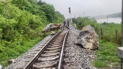
Quarry explosion, rocks as big as people flew onto National Highway 279 causing traffic safety problems
According to Mr. Hoa, earlier on October 28, Tay Trang VII quarry also exploded, causing rocks to fall onto the road at Km 105+200. Afterwards, workers used excavators to move the rocks off the highway. "I really hope that the authorities at all levels will soon take measures to thoroughly handle the above situation so that people can participate in traffic safely," he said.

Large stones rolling from Tay Trang VII Quarry onto Highway 279 cause traffic safety problems.
The above quarry is under the management of Nam Nhe 2A Company, the investor.
Giao Thong Newspaper has reflected people's opinions to the company.
Mr. Bui Anh Tuan, General Director of Nam Nhe 2A Company confirmed: "On October 28, the company exploded a mine and rock fell, and on October 29, it was due to rock falling on Highway 279. The mine site has been provided with complete documents, mine diagrams, and safe distances between mining locations."

Workers operating an excavator move rocks off the surface of Highway 279.
Regarding the distance between the quarry and the road, according to the reporter's records, the only entrance to Tay Trang VII quarry is directly connected to Highway 279 right at the curve and slope. About 150m away is the entrance to the quarry and the finished product processing area serving the Dien Bien cement factory. This section has the potential risk of losing traffic safety because the above location is located halfway up the slope, out of sight, and many sections of rock are scattered on the road.

According to Google Earth coordinates, the farthest location at the mining point in the mine map is only 125m from Highway 279, similarly 146m for the industrial explosives warehouse of the quarry belonging to Dien Bien Cement Factory.
Regarding this issue, Mr. Tran Quang Huy, Deputy Director of Road Joint Stock Company 226, the unit managing Highway 279, said: "The company has not received any procedures related to the request for permission to connect to Highway 279 from the Tay Trang VII mine. Not only is the connection procedure lacking, both mines have not yet installed a load weighing station. Notably, the trucks carrying rocks from the mine also spill materials, causing many locations on Highway 279 to deteriorate, potentially posing a high risk of traffic safety loss."

Red marks the location of the quarry connecting to National Highway 279, currently there is no licensing procedure from the competent authority.
Tay Trang VII quarry in Na U commune is located next to Highway 279 connecting Tay Trang International Border Gate to Dien Bien Phu City. This quarry was previously discovered to be operating outside the licensed area.
Currently, the regulations on safe distance when blasting and storing explosives are not guaranteed because according to the records, the farthest landmark of this mine is 350m, the closest is 110m, while the minimum safe distance for people is 300m and for surrounding construction equipment is 200m.
Source: https://www.baogiaothong.vn/dien-bien-mo-da-no-min-da-khung-bay-ra-giua-ql279-uy-hiep-an-toan-giao-thong-192241029222427504.htm
![[Photo] General Secretary To Lam, Secretary of the Central Military Commission attends the 12th Party Congress of the Army](https://vphoto.vietnam.vn/thumb/1200x675/vietnam/resource/IMAGE/2025/9/30/9b63aaa37ddb472ead84e3870a8ae825)
![[Photo] The 1st Congress of Phu Tho Provincial Party Committee, term 2025-2030](https://vphoto.vietnam.vn/thumb/1200x675/vietnam/resource/IMAGE/2025/9/30/1507da06216649bba8a1ce6251816820)
![[Photo] Solemn opening of the 12th Military Party Congress for the 2025-2030 term](https://vphoto.vietnam.vn/thumb/1200x675/vietnam/resource/IMAGE/2025/9/30/2cd383b3130d41a1a4b5ace0d5eb989d)
![[Photo] President Luong Cuong receives President of the Cuban National Assembly Esteban Lazo Hernandez](https://vphoto.vietnam.vn/thumb/1200x675/vietnam/resource/IMAGE/2025/9/30/4d38932911c24f6ea1936252bd5427fa)

![[Photo] Panorama of the cable-stayed bridge, the final bottleneck of the Ben Luc-Long Thanh expressway](https://vphoto.vietnam.vn/thumb/1200x675/vietnam/resource/IMAGE/2025/9/30/391fdf21025541d6b2f092e49a17243f)


Comment (0)