
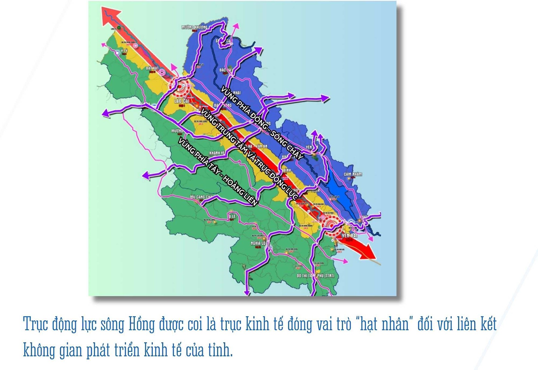
One of the important guiding viewpoints stated in the Resolution of the 1st Provincial Party Congress, term 2025 - 2030, is: Focusing on developing the Red River dynamic axis.
This is considered the economic axis that plays the "nuclear" role in linking the economic development space of the province, is a strategic development space, contributing to realizing the aspiration of the "Red River miracle" creating a driving force to promote economic and social development and environmental protection, ensuring national defense - security, and foreign affairs of the region and the whole country.
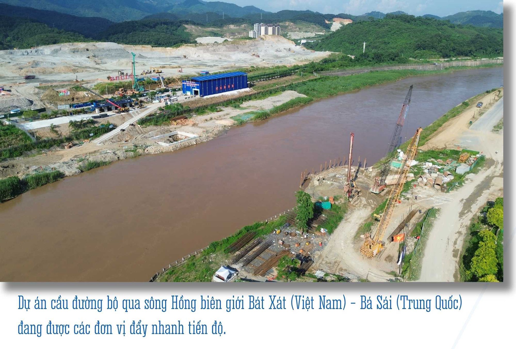
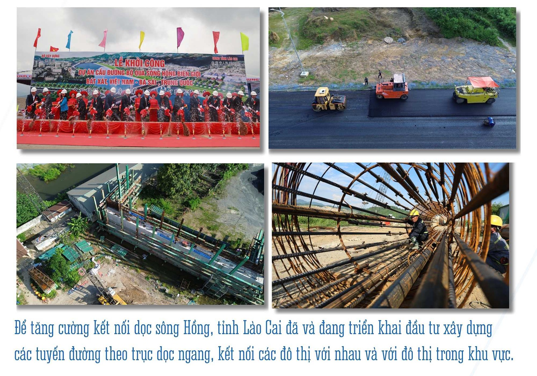
The road bridge project across the Red River bordering Bat Xat (Vietnam) - Ba Sai (China) is being accelerated by the units. To ensure the target of completion and handover by June 2026, the construction units are focusing on racing against time to complete the items.
The bridge is of great significance, not only because it is located on a vital traffic route, helping to shorten the travel distance between the two localities, but also creating a great driving force for the development of trade, tourism and cultural exchange between the two countries.
The completion of the project will open up many opportunities for economic and investment cooperation, while improving the lives of people on both sides of the border. This is not only one of the key infrastructure projects in the border area but also a project to realize the orientation of developing the Red River dynamic axis into a strategic space of the province.
The Red River flowing through Vietnam with a length of more than 500 km is not only the second largest river in the country in length but also closely associated with the history, culture and economy of the Northern region. For Lao Cai province, the section of the Red River flowing through the area possesses great potential for transportation, industry, urban and tourism. The river is an important waterway, connecting Lao Cai with the midland provinces, the Northern Delta and the Hanoi capital region.
This is an inter-regional economic corridor, facilitating trade, logistics development and economic cooperation. Along the Red River are areas with favorable conditions for industrial development, high-tech agriculture, urbanization and tourism. Industrial zones along the Red River will become economic driving forces for the entire midland and mountainous regions. The Red River is also closely linked to the lives and cultures of ethnic minorities.
Exploiting this cultural value for sustainable tourism development will bring double benefits, both promoting the economy and preserving heritage. It can be seen that development along the Red River helps Lao Cai create an economic space associated with environmental protection, preserving water resources and natural landscapes, while strengthening national defense and security in border areas.
Previously, the areas along the Red River in Lao Cai province were mainly rural areas or small towns with low population density. Traffic and infrastructure along the river were very limited, mainly small roads connecting to the old Lao Cai city center.
Since 2000, Lao Cai has begun to change strongly, which is also the time when the planning along the Red River has gradually taken shape. Urban areas have been planned to expand towards the banks of the Red River, river management projects, embankments on both banks with new residential areas, public works and commercial infrastructure have been implemented. Large bridges connecting the two banks of the Red River have been built, promoting trade between regions in the province. Over the decades, with efforts to manage the river, stable residential areas have been formed and developed into urban areas.
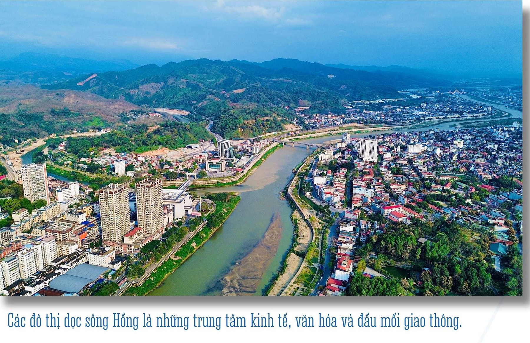
In addition to the largest urban areas of Lao Cai city and the old Yen Bai city, from the North down is a vibrant urban strip, such as: Bat Xat, Bao Thang, Bao Ha, Co Phuc, Bao Dap, Mau A, An Thinh... which are economic, cultural centers and traffic hubs.
One of the biggest advantages to soon realize the policy of developing the Red River dynamic axis into a strategic space of the province is that before Lao Cai and Yen Bai provinces merged, the planning in each locality had made the Red River the central development axis. Specifically, according to the Lao Cai Provincial Planning for the period 2021 - 2030, with a vision to 2050, Lao Cai province will focus on developing the dynamic economic axis along the Red River.
This is the economic axis that plays a "core" role in connecting the economic development space of the province; connecting regions, inter-regions and the whole country with the Southwest region - China. According to the Yen Bai Provincial Planning for the period 2021 - 2030, with a vision to 2050, the vertical axis connecting the North - South, along the Noi Bai - Lao Cai expressway, the Hanoi - Lao Cai railway and the inland waterway on the Red River is the vital economic axis.
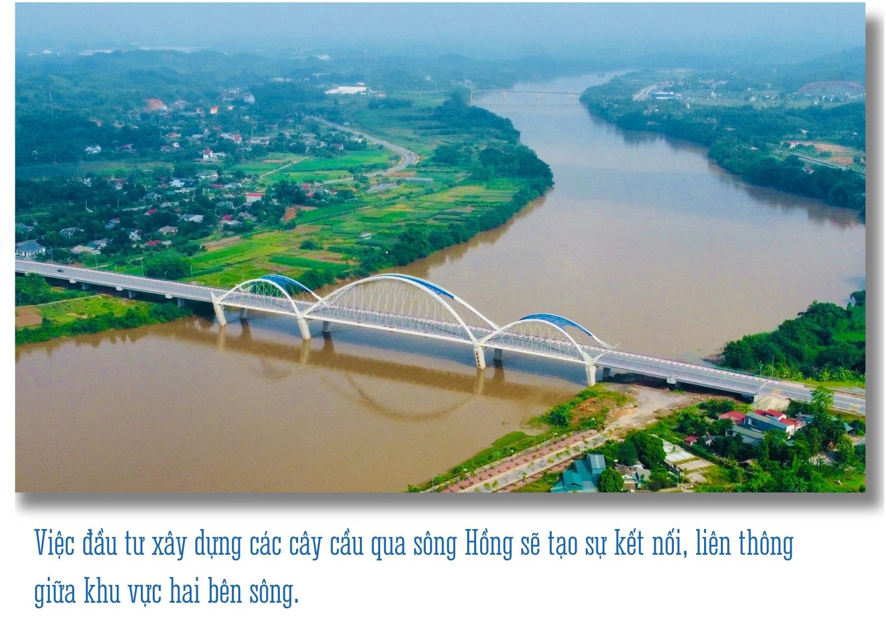
To strengthen connectivity along the Red River, Lao Cai province has been investing in the construction of horizontal and vertical routes, connecting urban areas with each other and with urban areas in the region. If previously, the connection along the Red River only included National Highway 70, National Highway 4E and the Hanoi - Lao Cai railway, now there are also Noi Bai - Lao Cai expressway, Pho Moi - Bao Ha - Lam Giang road, Kim Thanh - Ngoi Phat road... Bridges across the Red River have also been invested in and built to ensure connectivity on both sides of the river. In the North, the new Lang Giang and Phu Thinh bridges have been put into operation. In the South of the province, from Yen Bai bridge down just over 7km, there are 5 bridges built.
This year, the project to upgrade the Noi Bai - Lao Cai highway to 4 lanes; the Lao Cai - Hanoi - Hai Phong standard gauge railway project will be implemented. In addition, there are horizontal connecting traffic axes such as the traffic project connecting Lang Giang bridge - National Highway 70, the project connecting the Noi Bai - Lao Cai highway to Lai Chau; connecting the Noi Bai - Lao Cai highway to Sa Pa town, the project connecting National Highway 37, National Highway 32C with the Noi Bai - Lao Cai highway...
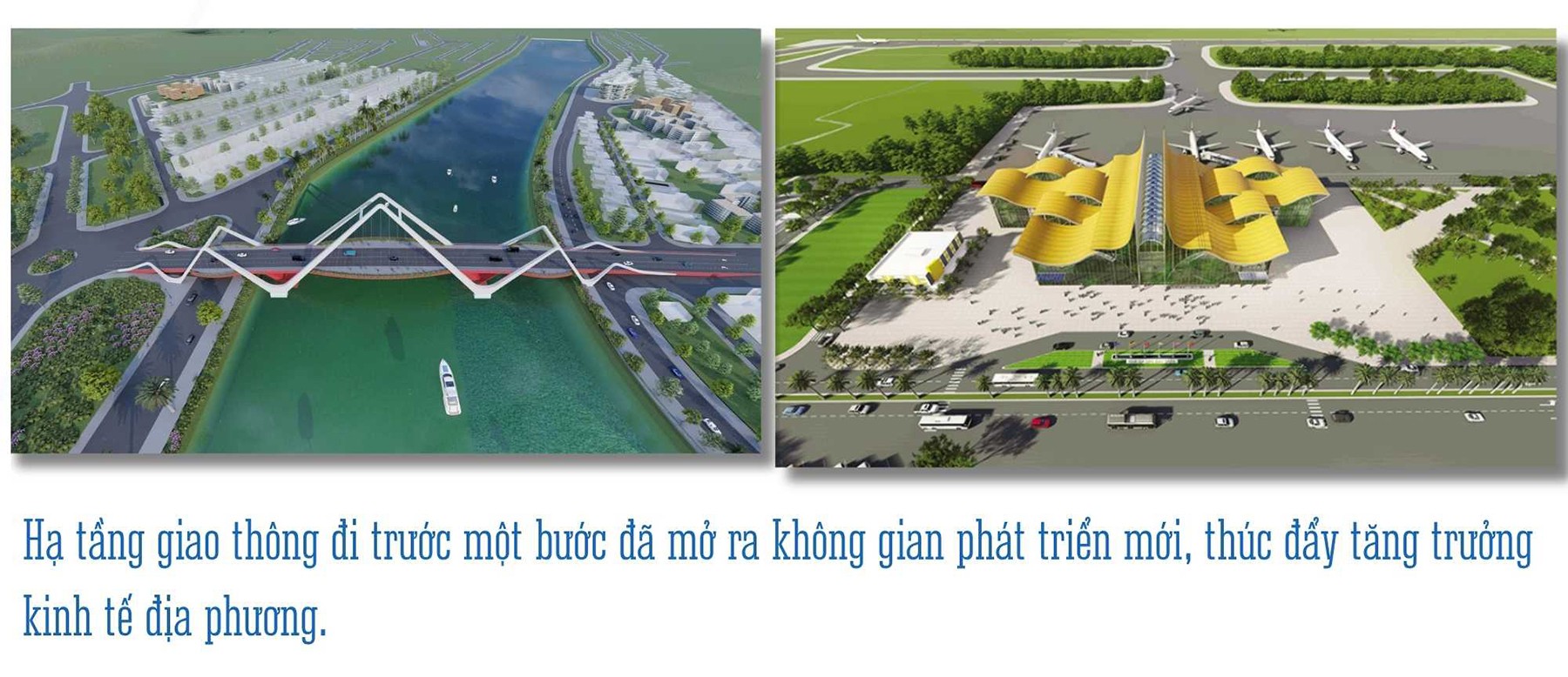
The strong investment in connecting infrastructure has created a lot of room for development, ensuring a harmonious balance between the two banks of the river and spreading evenly from north to south with clear subdivisions. The traffic infrastructure has been one step ahead, opening up space for urban development, creating momentum for the formation of new urban areas, attracting people and investors to live, produce, do business, and promote local economic growth.
With strategic vision and specific solutions, Lao Cai is gradually realizing its aspiration to become the center of socio-economic development of the Northern midlands and mountainous region. The Red River dynamic axis is not only a symbol of Lao Cai's prosperity but also a driving force for the overall development of the whole region. In the future, the Red River will not only be the flow of history and culture but also the flow of development, bringing Lao Cai and the Northern midlands and mountainous region into a new era of prosperity and sustainability.
Source: https://baolaocai.vn/truc-dong-luc-song-hong-khong-giant-phat-trien-chien-luoc-cua-tinh-post883307.html

![[Photo] Panorama of the cable-stayed bridge, the final bottleneck of the Ben Luc-Long Thanh expressway](https://vphoto.vietnam.vn/thumb/1200x675/vietnam/resource/IMAGE/2025/9/30/391fdf21025541d6b2f092e49a17243f)
![[Photo] President Luong Cuong receives President of the Cuban National Assembly Esteban Lazo Hernandez](https://vphoto.vietnam.vn/thumb/1200x675/vietnam/resource/IMAGE/2025/9/30/4d38932911c24f6ea1936252bd5427fa)
![[Photo] The 1st Congress of Phu Tho Provincial Party Committee, term 2025-2030](https://vphoto.vietnam.vn/thumb/1200x675/vietnam/resource/IMAGE/2025/9/30/1507da06216649bba8a1ce6251816820)
![[Photo] General Secretary To Lam, Secretary of the Central Military Commission attends the 12th Party Congress of the Army](https://vphoto.vietnam.vn/thumb/1200x675/vietnam/resource/IMAGE/2025/9/30/9b63aaa37ddb472ead84e3870a8ae825)
![[Photo] Solemn opening of the 12th Military Party Congress for the 2025-2030 term](https://vphoto.vietnam.vn/thumb/1200x675/vietnam/resource/IMAGE/2025/9/30/2cd383b3130d41a1a4b5ace0d5eb989d)


Comment (0)