
According to the National Center for Hydro-Meteorological Forecasting, at 7:00 p.m. on September 23, the center of the super typhoon was located at about 20.8 degrees North latitude; 116.1 degrees East longitude, in the northeastern sea area of the North East Sea. The strongest wind near the center of the super typhoon was level 15 - 16 (167 - 201 km/h), gusting above level 17. The storm moved in a West-Northwest direction at a speed of about 20 km/h.
The specific forecast for the development of storm No. 9 in the coming days is as follows: On the mainland along the coast of Guangdong province (China) by 7:00 p.m. on September 24, the storm will be about 350 km east of Mong Cai (Quang Ninh) with strong winds of level 13, gusting over level 16; moving in the West Northwest direction, traveling 20 - 25 km per hour and gradually weakening. The affected area is the sea area north of the North East Sea with disaster risk level 4; the east of the North Gulf of Tonkin with disaster risk level 3.
And at 7:00 a.m. on September 25, the storm was in the sea area of Quang Ninh - Hai Phong with strong winds of level 9, gusts of level 11; moving westward, traveling 20 - 25 km per hour and continuing to weaken. The affected area is the sea area northwest of the North East Sea; the area north of the Gulf of Tonkin with a level 3 natural disaster risk level.
However, by 7 p.m. on September 25, the storm on the mainland of the Northeast region of the North had only wind strength below level 6; moving in the West Southwest direction, traveling 25 km per hour and weakening into a tropical depression, then into a low pressure area. The affected area is the Northern Gulf of Tonkin, the Northeast region of the North with a level 3 natural disaster risk level.
Due to the impact of the storm, the northern sea area of the North East Sea has strong winds of level 10 - 13, the area near the center of the super storm has winds of level 14 - 16, gusts above level 17, waves over 10m high; rough seas.
From September 24, the eastern sea area of the Northern Gulf of Tonkin (including Bach Long Vi special zone) will have winds gradually increasing to level 6 - 7, gusting to level 9. From the evening and night of September 24, the northern Gulf of Tonkin (including Bach Long Vi special zone, Van Don, Co To, Cat Hai and Hon Dau island) will have winds gradually increasing to level 8, waves 2 - 4m high, the area near the storm center will have winds of level 9 - 10, gusting to level 12, waves 3 - 5m high; very rough seas.
On land, the situation is as follows: From early morning on September 25, coastal areas from Quang Ninh to Ninh Binh will have winds gradually increasing to level 6 - 7, near the storm center level 8 - 9, gusting to level 11; inland areas in the Northeast, there will be strong winds of level 5, in some places level 6, gusting to level 7 - 8.
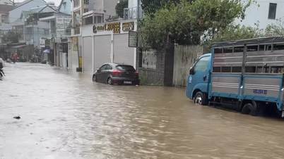
From the night of September 24 to the end of the night of September 26, the Northern region, Thanh Hoa and Nghe An will have heavy to very heavy rain with common rainfall of 100 - 250 mm, locally over 400 mm. Heavy rain is likely to cause flooding in low-lying areas; flash floods on small rivers and streams, landslides on steep slopes. Beware of heavy rain causing urban flooding.
Due to the influence of the wide storm circulation, it is necessary to guard against the risk of thunderstorms, tornadoes and strong gusts of wind both before and during the storm's landfall.
Faced with the dangerous developments of the storm, the Prime Minister issued Official Dispatch 171/CD-TTg, dated September 23; in which he requested the Minister of Agriculture and Environment to provide the most complete, timely and accurate information on the developments and impacts of the storm, warning of the worst possible scenario (including the risk of storm No. 10 appearing in the East Sea right after storm No. 9 makes landfall) so that authorities and people know and proactively deploy appropriate and effective response work.
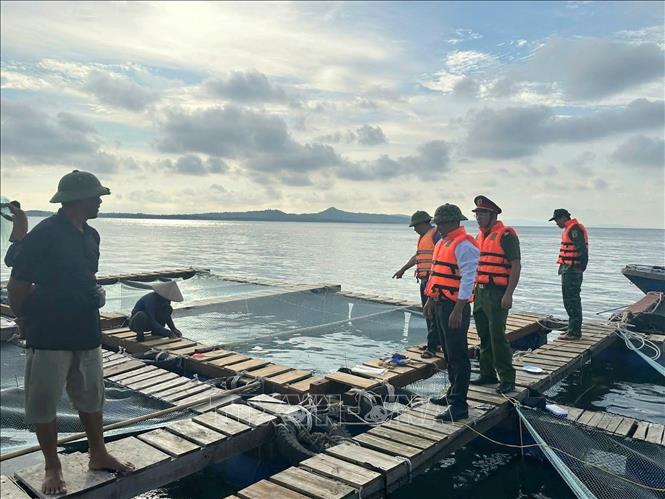
The Secretaries and Chairmen of the People's Committees of coastal provinces and cities from Quang Ninh to Thanh Hoa focused on leading and directing the implementation of measures to respond to the super typhoon; ensuring safety for ships operating at sea and along the coast; reviewing plans, being ready to organize evacuation and relocation of residents to ensure safety before the storm makes landfall, and deploying rescue work when bad situations occur...
Source: https://baotintuc.vn/thoi-su/nguyco-cao-sat-lo-de-ke-bien-tinh-quang-ninh-do-anh-huong-bao-so-9-20250923212547569.htm


![[Photo] Hanoi morning of October 1: Prolonged flooding, people wade to work](https://vphoto.vietnam.vn/thumb/1200x675/vietnam/resource/IMAGE/2025/10/1/189be28938e3493fa26b2938efa2059e)


![[Photo] Panorama of the cable-stayed bridge, the final bottleneck of the Ben Luc-Long Thanh expressway](https://vphoto.vietnam.vn/thumb/1200x675/vietnam/resource/IMAGE/2025/9/30/391fdf21025541d6b2f092e49a17243f)


Comment (0)