
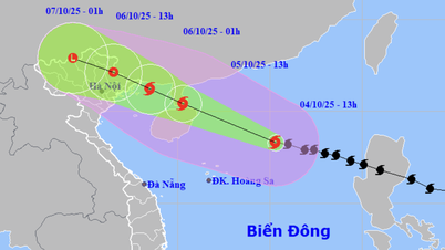
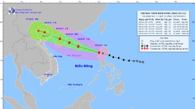
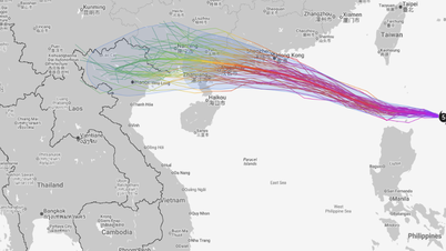
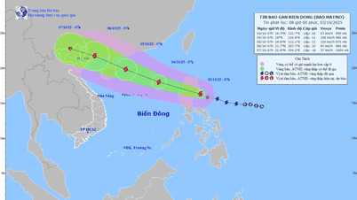
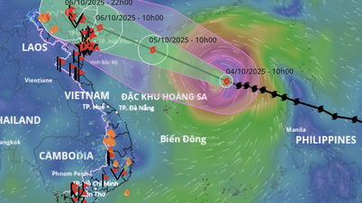
It is forecasted that by September 22, Ragasa will continue to strengthen to level 14-15, gusting over level 17, 240 km northeast of Ludong Island. By September 23, Ragasa will reach super typhoon strength of level 16, gusting over level 17 in the sea area north of Ludong Island. The dangerous area in the East Sea is identified as the area north of latitude 18 degrees North, east of longitude 118 degrees East. The disaster risk level is warned at level 4.
By September 24, the storm moved into the North East Sea, about 140 km southeast of Hong Kong (China), maintaining wind speed of level 16, gusting above level 17, then tending to move to the West Southwest and gradually weakening.
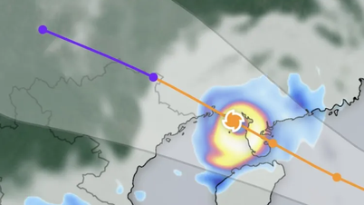
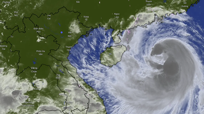
From the afternoon of September 22, the Northeast of the East Sea had strong winds of level 6-7, then increased to level 8-9, gusting to level 11. On the night of September 22, the area near the storm center had strong winds of level 14-16, gusting to level 17, waves over 10 m high, and rough seas, posing great danger to ships.

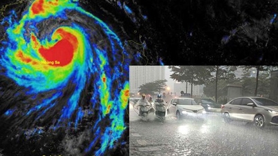
The National Center for Hydro-Meteorological Forecasting recommends that localities, authorities and fishermen need to closely monitor the storm situation and proactively take response measures to minimize damage caused by super storm Ragasa.
On land, the North, Thanh Hoa, the Central Highlands and the South have showers and thunderstorms, with widespread rainfall of 15-30 mm, locally over 100 mm. The South Central Coast, including Da Nang City, has scattered showers and thunderstorms, with rainfall of 10-30 mm, in some places over 70 mm.
During thunderstorms, there is a possibility of tornadoes, lightning, hail and strong gusts of wind. There is a risk of heavy rain over 70 mm/3 hours, with the potential for flash floods, landslides and inundation.
Weather forecast for regions across the country:
Hanoi capital is cloudy with scattered showers and thunderstorms, locally heavy rain. Light wind. During thunderstorms there is a possibility of tornadoes, lightning, hail and strong gusts of wind. Lowest temperature 24-26 degrees Celsius. Highest temperature 30-32 degrees Celsius.
The Northwestern provinces are cloudy with scattered showers and thunderstorms, with some places experiencing heavy to very heavy rain. Light winds. During thunderstorms, there is a possibility of tornadoes, lightning, and strong gusts of wind. The lowest temperature is 22-25 degrees Celsius, some places below 22 degrees Celsius. The highest temperature is 29-32 degrees Celsius.
The Northeastern region is cloudy with scattered showers and thunderstorms, with some places experiencing heavy to very heavy rain. Light winds. During thunderstorms, there is a possibility of tornadoes, lightning, and strong gusts of wind. The lowest temperature is 23-26 degrees Celsius, in mountainous areas, some places below 22 degrees Celsius. The highest temperature is 29-32 degrees Celsius.
Provinces from Thanh Hoa to Hue will be cloudy with scattered showers and thunderstorms; in the late afternoon and evening, there will be scattered showers and thunderstorms. Light winds. Thunderstorms may include tornadoes, lightning, hail, and strong gusts of wind. Lowest temperature 23-26 degrees Celsius. Highest temperature 30-33 degrees Celsius.
The South Central Coast region is cloudy with scattered showers and thunderstorms; in the afternoon and evening, there will be scattered showers and thunderstorms, with some heavy rain in some places. Southwest wind level 2-3. During thunderstorms, there is a possibility of tornadoes, lightning, hail and strong gusts of wind. Lowest temperature 23-26 degrees Celsius. Highest temperature 31-34 degrees Celsius.
The Central Highlands is cloudy with scattered showers and thunderstorms, with some places experiencing heavy to very heavy rain. Southwesterly winds at level 2-3. Thunderstorms are likely to produce tornadoes, lightning, hail, and strong gusts of wind. Lowest temperature 20-23 degrees Celsius. Highest temperature 27-30 degrees Celsius.
The South is cloudy with scattered showers and thunderstorms, with some heavy rain in some places. Southwesterly winds level 2-3. Thunderstorms may include tornadoes, lightning, hail and strong gusts of wind. Lowest temperature 24-27 degrees Celsius. Highest temperature 29-32 degrees Celsius.
Ho Chi Minh City is cloudy with scattered showers and thunderstorms, with some heavy rain in some places. Southwest wind level 2-3. During thunderstorms, there is a possibility of tornadoes, lightning, hail and strong gusts of wind. Lowest temperature 24-26 degrees Celsius. Highest temperature 29-31 degrees Celsius.
Source: https://www.sggp.org.vn/sieu-bao-ragasa-manh-cap-16-giat-tren-cap-17-tien-vao-bien-dong-post814101.html
![[Photo] General Secretary To Lam attends the 8th Congress of the Central Public Security Party Committee](https://vphoto.vietnam.vn/thumb/1200x675/vietnam/resource/IMAGE/2025/10/4/79fadf490f674dc483794f2d955f6045)
![[Photo] Bustling Mid-Autumn Festival at the Museum of Ethnology](https://vphoto.vietnam.vn/thumb/1200x675/vietnam/resource/IMAGE/2025/10/4/da8d5927734d4ca58e3eced14bc435a3)

![[Photo] Solemn opening of the 8th Congress of the Central Public Security Party Committee, term 2025-2030](https://vphoto.vietnam.vn/thumb/1200x675/vietnam/resource/IMAGE/2025/10/4/f3b00fb779f44979809441a4dac5c7df)


![Bringing G-DRAGON 2025 WORLD TOUR [Übermensch] to Vietnam, 8Wonder turns the impossible into possible](https://vphoto.vietnam.vn/thumb/402x226/vietnam/resource/IMAGE/2025/10/4/f2e1e99f90a54c788bb3acaba910ba8b)


![[VIDEO] Summary of Petrovietnam's 50th Anniversary Ceremony](https://vphoto.vietnam.vn/thumb/402x226/vietnam/resource/IMAGE/2025/10/4/abe133bdb8114793a16d4fe3e5bd0f12)

![[VIDEO] GENERAL SECRETARY TO LAM AWARDS PETROVIETNAM 8 GOLDEN WORDS: "PIONEER - EXCELLENT - SUSTAINABLE - GLOBAL"](https://vphoto.vietnam.vn/thumb/402x226/vietnam/resource/IMAGE/2025/7/23/c2fdb48863e846cfa9fb8e6ea9cf44e7)


Comment (0)