
At 7 a.m. this morning, super typhoon Rasaga was classified by the Japan Meteorological Agency (JMA) as an extremely strong typhoon - the highest classification level for a cyclone. A tropical cyclone in the northwest Pacific Ocean (with 10-minute sustained winds) reached speeds of 110 kts (equivalent to wind speeds of 205 km/h), slightly stronger than a super typhoon. Typhoon Yagi 2024 (105 kts).
What is the strongest level of super typhoon Ragasa and how dangerous is it?
But according to international storm forecasting centers, this is not the strongest intensity of super typhoon Ragasa. Super typhoon Ragasa is forecast to reach its strongest intensity on September 22-23 and then gradually weaken.
In particular, the Chinese meteorological agency predicted that super typhoon Ragasa could reach its strongest speed of up to 223 km/h, equivalent to a level 17 storm.
Forecasting at a higher level, the Hong Kong Meteorological Department (China) predicted that super typhoon Ragasa could reach a maximum speed of 240 km/h (intensity above level 17), gusting above level 17.
Also according to the agencies storm forecast International warnings say that storms with winds above level 17 will cause extremely large waves, possibly over 10 meters high, sinking or destroying all types of ships, including large tonnage ships.
In dangerous storm waters, ships that cannot move or take shelter in time will be swept away by waves, sink or drift ashore, causing heavy losses of life and property.
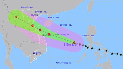
Super typhoon Ragasa causes 10 meter high waves, enters the East Sea tonight
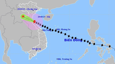
Super typhoon Ragasa will weaken when entering the Gulf of Tonkin
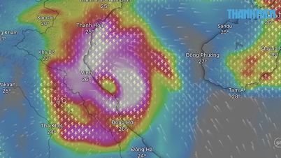
According to the National Center for Hydro-Meteorological Forecasting, at the current speed of about 20 km/hour, it is forecast that around the evening of September 22, super typhoon Ragasa will move into the East Sea, becoming a typhoon. Storm No. 9 in 2025. Super storm intensity when entering the East Sea is level 17, gusting above level 17.
The National Center for Hydro-Meteorological Forecasting said that on September 24, when moving to the sea south of Guangdong province (China), the northern circulation of super typhoon Ragasa will be affected by terrain friction and is forecast to weaken. When entering the Gulf of Tonkin, the storm's intensity is forecast to decrease by 2-4 levels compared to the strongest time offshore.
By early morning of September 25, storm Ragasa will pass the Leizhou peninsula (China) and move into the Gulf of Tonkin with a strong intensity of level 12 - level 14, gusting to level 15 - level 16. It is forecasted that on September 25, the storm will move into our mainland, with the focus being from Quang Ninh - Ha Tinh .
Source: https://thanhnien.vn/sieu-bao-ragasa-nguy-hiem-ra-sao-185250922141100504.htm


![[Photo] General Secretary To Lam receives Chairman of the State Duma of the Russian Federation Vyacheslav Volodin](https://vphoto.vietnam.vn/thumb/1200x675/vietnam/resource/IMAGE/2025/9/29/3814a68959e848f586178624b6bd66e5)

![[Photo] General Secretary To Lam chairs the meeting of the Central Steering Committee on preventing and combating corruption, waste and negativity](https://vphoto.vietnam.vn/thumb/1200x675/vietnam/resource/IMAGE/2025/9/29/fb2a8712315d4213a16322588c57b975)


Comment (0)