
The strongest wind near the storm center is level 11-12 (103-133 km/h), gusting to level 15. The storm moves in a West-Northwest direction, at a speed of 35-40 km/h, nearly double the average speed. This is a strong storm, moving very quickly, with a wide area of influence, which can cause combined effects including strong winds, heavy rain, floods, flash floods, landslides and coastal flooding.
Forecast as of 4:00 a.m. on September 28, the storm center is at 16.3 degrees North latitude; 110.0 degrees East longitude, about 180 km east of Da Nang . Strong winds of level 12-13, gusts of level 16. The dangerous area in the East Sea is determined from 11.5-18.5 degrees North latitude and east of longitude 108.0 degrees East longitude. The disaster risk level is level 3. Areas directly affected include the North and middle of the East Sea (including Hoang Sa sea area) and the sea area from Ha Tinh to Quang Ngai.
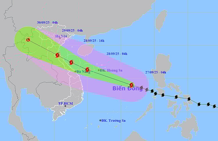
At 4 p.m. the same day, the storm entered the sea area from Ha Tinh - Thua Thien Hue with sustained winds of level 12-13, gusting to level 16. From the morning of September 29, the storm's center was expected to make landfall from Nghe An to North Quang Tri, gradually weakening to level 8-9, gusting to level 11. After that, the storm continued to move to Upper Laos and gradually dissipated.
At sea, the North and Central East Sea (including Hoang Sa sea area) has strong winds of level 8-9, near the storm center level 10-13, gusts of level 16, waves 6-10 m high, rough seas. From the night of September 27, the Thanh Hoa - Quang Ngai sea area has gradually increased winds to level 8-9, gusts of 11-12, waves 5-7 m high.
Since the morning of September 28, the northern Gulf of Tonkin has also had strong winds of level 8-9, gusting to level 11, and very rough seas. Storm surges along the coast from Ninh Binh to Ha Tinh could reach 1-2 m, and in the Thanh Hoa-Nghe An area, some places could reach 1.5-2 m, posing a risk of flooding dykes, coastal roads, and aquaculture areas.
On land, from the afternoon of September 28, Thanh Hoa to Northern Quang Tri provinces will have strong winds of level 6-7, near the storm center of level 10-12, gusting to level 14, with the risk of falling trees, electric poles, and damaging houses. Quang Ninh - Ninh Binh and Southern Quang Tri - Thua Thien Hue areas will have strong winds of level 6-7, gusting to level 8-9.
Widespread heavy rain is forecast to last from September 28-30 in the North and provinces from Thanh Hoa to Thua Thien Hue, with rainfall ranging from 100-300 mm, with some places experiencing over 400 mm. Particularly in the Northern Delta and Thanh Hoa - Ha Tinh provinces, there will be very heavy rain of 200-400 mm, with some places experiencing over 600 mm, with a high risk of flash floods, landslides and urban flooding.
Authorities have recommended that coastal localities from Thanh Hoa to Quang Ngai, the Northern and North Central regions, urgently deploy preventive measures to ensure safety for boats, residents and infrastructure works as storm No. 10 is approaching.
Weather forecast for regions across the country:
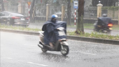
Hanoi capital is cloudy, with moderate rain, heavy rain and thunderstorms in the morning, and very heavy rain in some places; scattered showers and thunderstorms later. East wind level 2-3. During thunderstorms, there is a possibility of tornadoes, lightning and strong gusts of wind. Lowest temperature 24-26 degrees Celsius. Highest temperature 27-29 degrees Celsius.
The Northwestern provinces are cloudy with scattered showers and thunderstorms, some places have heavy rain; in the morning, in the South of Phu Tho, there will be moderate rain, heavy rain and thunderstorms, some places have very heavy rain. Light wind. During thunderstorms, there is a possibility of tornadoes, lightning and strong gusts of wind. The lowest temperature is 22-25 degrees Celsius, some places below 21 degrees Celsius. The highest temperature is 26-29 degrees Celsius.
The Northeastern region is cloudy, with scattered showers and thunderstorms in the morning, with some places experiencing heavy to very heavy rain; later scattered showers and thunderstorms, with some places experiencing heavy rain. East to northeast winds at level 2-3. During thunderstorms, there is a possibility of tornadoes, lightning, and strong gusts of wind. Lowest temperature 23-26 degrees Celsius. Highest temperature 26-29 degrees Celsius.
Provinces from Thanh Hoa to Hue are cloudy with scattered showers and thunderstorms, locally heavy rain; in the North, in the morning, there will be moderate rain, heavy rain and scattered thunderstorms, locally very light rain. North to northwest wind level 2-3. During thunderstorms, there is a possibility of tornadoes, lightning, hail and strong gusts of wind. Lowest temperature 23-26 degrees Celsius. Highest temperature 27-30 degrees Celsius.
The South Central Coast region is cloudy with scattered showers and thunderstorms, with some heavy rain in some places. West to southwest winds at level 2-3. During thunderstorms, there is a possibility of tornadoes, lightning, hail and strong gusts of wind. Lowest temperature 24-27 degrees Celsius. Highest temperature 29-32 degrees Celsius.
Central Highlands cloudy, scattered showers and thunderstorms, locally heavy rain (rain concentrated in the afternoon and night). Southwest wind level 2-3. During thunderstorms, there is a possibility of tornadoes, lightning, hail and strong gusts of wind. Lowest temperature 19-22 degrees Celsius. Highest temperature 25-28 degrees Celsius.
The South is cloudy with scattered showers and thunderstorms, with some places experiencing heavy rain (rain is concentrated in the afternoon and evening). Southwesterly winds level 2-3. During thunderstorms, there is a possibility of tornadoes, lightning, hail and strong gusts of wind. Lowest temperature 24-27 degrees Celsius. Highest temperature 30-33 degrees Celsius.
Ho Chi Minh City is cloudy with scattered showers and thunderstorms; in the late afternoon and evening there will be scattered showers and thunderstorms, with some heavy rain in some places. Southwest wind level 2-3. During thunderstorms there is a possibility of tornadoes, lightning, hail and strong gusts of wind. Lowest temperature 24-26 degrees Celsius. Highest temperature 31-33 degrees Celsius.
Source: https://baotintuc.vn/xa-hoi/thoi-tiet-ngay-279-bao-so-10-di-chuyen-gap-doi-toc-do-trung-binh-cuong-do-manh-20250927060052475.htm

![[Photo] Soldiers guard the fire and protect the forest](https://vphoto.vietnam.vn/thumb/1200x675/vietnam/resource/IMAGE/2025/9/27/7cab6a2afcf543558a98f4d87e9aaf95)


![[Photo] Prime Minister Pham Minh Chinh attends the 1st Hai Phong City Party Congress](https://vphoto.vietnam.vn/thumb/1200x675/vietnam/resource/IMAGE/2025/9/27/676f179ddf8c4b4c84b4cfc8f28a9550)


Comment (0)