
This is a very fast moving storm (nearly twice the average speed), strong intensity, wide range of influence, can cause combined effects: strong winds, heavy rains, floods, flash floods, landslides and coastal flooding. The strongest wind near the storm center is level 11-12 (103-133km/h), gusting to level 15.
Storm forecast (next 24–60 hours) :
07:00 September 28:
• Location: 16.7°N – 109.3°E, on the sea area of Southern Quang Tri – Quang Ngai, ~130km East Northeast of Da Nang .
• Movement: West Northwest, 30-35km/h, with the possibility of strengthening.
• Intensity: Level 12-13, jerk level 16.
• Danger zone: 12.0°N–19.0°N; west of longitude 119.0°E.
• Disaster risk level: Level 3.
• Affected areas: North and Central East Sea (including Hoang Sa); sea area from Ha Tinh to Quang Ngai.
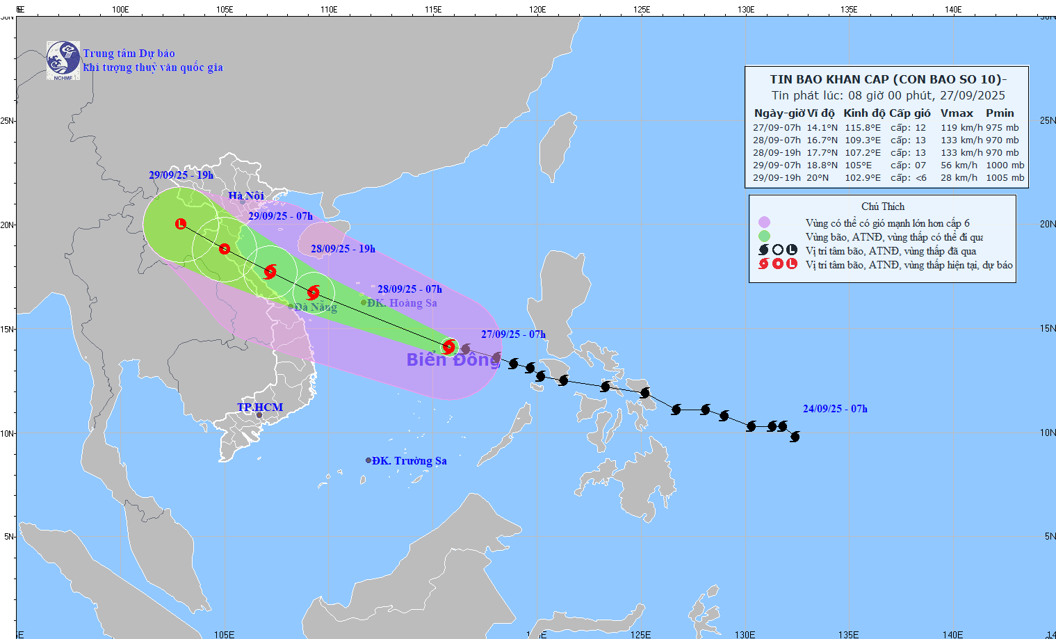
7:00 p.m. September 28:
• Location: 17.7°N – 107.2°E, on the sea from Nghe An – Hue.
• Movement: West Northwest, 20-25km/h.
• Intensity: Level 12-13, jerk level 16.
• Danger zone: North of latitude 14.0°N; West of longitude 112.5°E.
• Disaster risk level: Level 3.
• Affected areas: Northwest of the East Sea (including Hoang Sa), Northwest of the Central East Sea, from Thanh Hoa to Quang Ngai (Hon Ngu, Con Co, Ly Son), Northern Gulf of Tonkin (Bach Long Vy, Van Don, Co To, Cat Hai, Hon Dau); on land from Ninh Binh to Hue.
07:00 September 29:
• Location: 18.8°N – 105.0°E, on the mainland of Nghe An – Ha Tinh.
• Moving: West Northwest, 20-25km/h, weakening into a tropical depression.
• Intensity: Level 8, shock level 10.
• Danger zone: North of latitude 15.0°N; West of longitude 110.5°E.
• Disaster risk level: Level 3.
• Affected areas: Northwest of the East Sea (including Hoang Sa), from Thanh Hoa to Quang Ngai (Hon Ngu, Con Co, Ly Son), Northern Gulf of Tonkin (Bach Long Vy, Van Don, Co To, Cat Hai, Hon Dau); on land from Ninh Binh to Hue.
7:00 p.m. September 29:
• Location: 20.0°N – 102.9°E, in the Upper Laos region.
• Moving: West Northwest, 20-25km/h, gradually weakening into a low pressure area.
• Intensity: below level 6.
• Danger zone: North of latitude 17.0°N; West of longitude 108.0°E.
• Disaster risk level: Level 3.
• Affected areas: sea areas from Thanh Hoa to North Quang Tri (Hon Ngu, Con Co) and North Gulf of Tonkin (Bach Long Vy, Van Don, Co To, Cat Hai, Hon Dau); on land from Ninh Binh to North Quang Tri.
Forecasting the impact of storms
At sea:
• North and Central East Sea (including Hoang Sa): wind 8-9; near storm center 10-13, gust 16; waves 6.0-10.0m; rough sea.
• Evening of September 27, Thanh Hoa - Quang Ngai sea area (Hon Ngu, Con Co, Ly Son): wind 6-7, gust 8-9, waves 3.0-5.0m; near morning of September 28 increased to 8-9, near the storm center 10-13, gust 16; waves 5.0-7.0m; rough sea.
• Early morning of September 28, Northern Gulf of Tonkin (Bach Long Vy, Van Don, Co To, Cat Hai, Hon Dau): wind 6-7, later strong 8-9, gust 11; waves 3.0-5.0m; very rough seas.
Storm surge:
• Coastal and island areas from Ninh Binh - Ha Tinh: 1.0-2.0m; Thanh Hoa and Nghe An only: 1.5-2.0m.
• Risk of flooding on dikes, coastal roads, and river mouths at night – September 28.
On land:
• From the afternoon of September 28, Thanh Hoa - Northern Quang Tri: wind 6-7, increasing to 8-9, near the storm center 10-12, gust 14 (dangerous, can cause trees, electric poles, houses to fall).
• Quang Ninh – Ninh Binh and South Quang Tri – Hue: wind 6-7, gust 8-9.
Heavy rain:
• From the night of September 27–30: Northern region and Thanh Hoa – Hue will have 100–300mm of rain, locally >400mm.
• Northern Delta and Thanh Hoa - Quang Tri: 200-400mm, locally >600mm.
Source: https://baonghean.vn/tin-bao-moi-nhat-con-bao-so-10-hoi-7-gio-ngay-27-9-tren-vung-bien-nam-quang-tri-quang-ngai-10307187.html


![[Photo] Prime Minister Pham Minh Chinh attends the groundbreaking ceremony of two key projects in Hai Phong city](https://vphoto.vietnam.vn/thumb/1200x675/vietnam/resource/IMAGE/2025/9/27/6adba56d5d94403093a074ac6496ec9d)


Comment (0)