
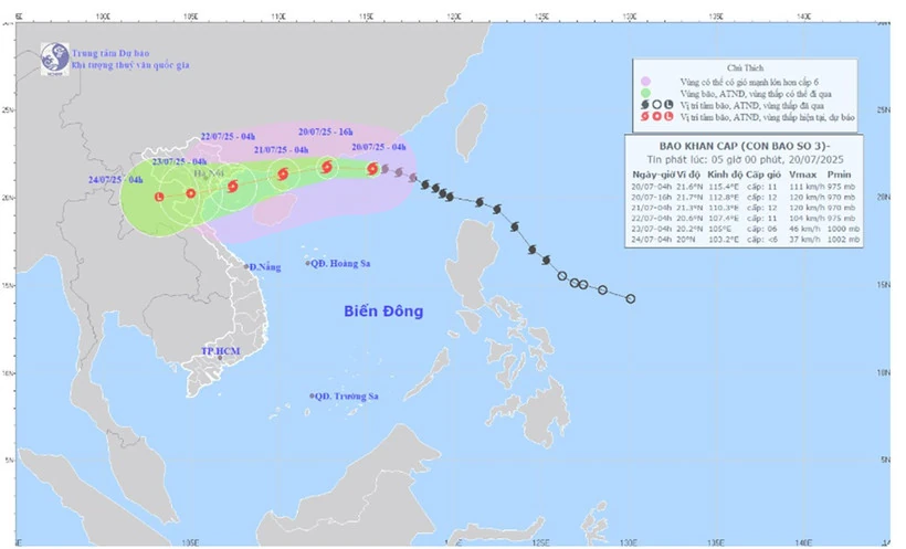
Map of forecast path and intensity of storm No. 3 issued at 5:00 a.m. on July 20. (Photo: National Center for Hydro-Meteorological Forecasting)
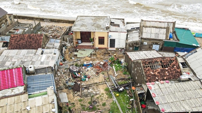
The strongest wind near the storm center is level 11 (103-117km/h), gusting to level 14; moving in the West Northwest direction at a speed of about 20-25km/h.
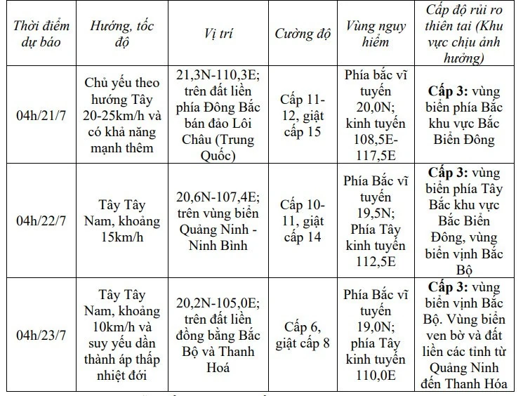
Storm forecast ( next 24 to 72 hours):
Forecast for the next 72 to 96 hours, storm No. 3 will move mainly in the West Southwest direction, traveling 5-10km per hour and continue to weaken.
From the night of July 20, the northern sea area of Bac Bo Gulf (including the special zones of Bach Long Vi, Co To, Cat Hai) will have winds gradually increasing to level 6-7, then increasing to level 8-9, the area near the storm center will have level 10-11, gusting to level 14, waves 2-4m high, the area near the center will have 3-5m. The sea will be very rough.
From July 21, the sea in the southern Gulf of Tonkin will have winds gradually increasing to level 6-7, near the storm center level 8-9, gusting to level 11, waves 2-4m high. The sea will be very rough.
Vessels operating in the above mentioned dangerous areas are susceptible to the impact of storms, whirlwinds, strong winds and large waves.
On land: From the evening and night of July 21, on land from Quang Ninh to Thanh Hoa, winds will gradually increase to level 7-9, gusting to level 10-11; further inland, winds will increase to level 6-7, gusting to level 8-9; near the storm center, winds will increase to level 10-11, gusting to level 14.
From July 21 to July 23, in the Northern and North Central regions, there is a possibility of widespread heavy rain with common rainfall of 100-200mm, locally over 300mm, especially in the Northeast, the Northern Delta, Thanh Hoa and Nghe An , there will be heavy to very heavy rain with common rainfall of 200-350mm, locally over 600mm.
Warning of risk of heavy rain (>150mm/3 hours).
Source nhandan.vn
Source: https://baophutho.vn/tin-khan-cap-ve-con-bao-so-3-236419.htm
![[Photo] General Secretary To Lam attends the ceremony to celebrate the 80th anniversary of the post and telecommunications sector and the 66th anniversary of the science and technology sector.](https://vphoto.vietnam.vn/thumb/1200x675/vietnam/resource/IMAGE/2025/9/29/8e86b39b8fe44121a2b14a031f4cef46)

![[Photo] Many streets in Hanoi were flooded due to the effects of storm Bualoi](https://vphoto.vietnam.vn/thumb/1200x675/vietnam/resource/IMAGE/2025/9/29/18b658aa0fa2495c927ade4bbe0096df)

![[Photo] National Assembly Chairman Tran Thanh Man chairs the 8th Conference of full-time National Assembly deputies](https://vphoto.vietnam.vn/thumb/1200x675/vietnam/resource/IMAGE/2025/9/29/2c21459bc38d44ffaacd679ab9a0477c)
![[Photo] General Secretary To Lam receives US Ambassador to Vietnam Marc Knapper](https://vphoto.vietnam.vn/thumb/1200x675/vietnam/resource/IMAGE/2025/9/29/c8fd0761aa184da7814aee57d87c49b3)


![[Infographics] Time, location, content of the 1st Congress of An Giang Provincial Party Committee, term 2025 - 2030](https://vphoto.vietnam.vn/thumb/402x226/vietnam/resource/IMAGE/2025/9/30/fed466586ad84c3ebea914be993018ca)


![[Infographics] An Giang tourism makes a spectacular breakthrough](https://vphoto.vietnam.vn/thumb/402x226/vietnam/resource/IMAGE/2025/9/30/e472f9f3f91d407ba4b7de460fb0481d)


Comment (0)