
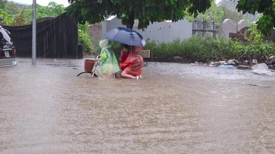
Due to the influence of storm No. 6 (storm Tra Mi), Ho Chi Minh City and some provinces in the Southeast experienced moderate to heavy rain at many times of the day, and some roads were flooded.
According to the Southern Hydrometeorological Station, the situation causing thunderstorms in the Ho Chi Minh City area and the Southeast provinces is due to the weak strengthening of cold air. The tropical convergence zone has an axis through the Central Central region connecting with storm No. 6 (storm Tra Mi) moving in the Southwest direction, making landfall in the provinces from Thua Thien Hue - Da Nang . The Southwest wind has a medium to strong intensity.
Monitoring on satellite cloud images, weather radar images and lightning location (at 1:40 p.m. on October 27) shows that the thunderstorm area is developing and causing rain with thunderstorms and lightning in Binh Chanh area, Binh Tan district, Tan Phu, Hoc Mon district, Cu Chi.
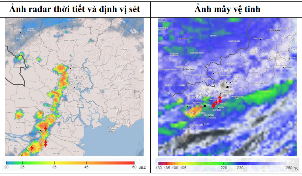
In addition, thunderstorms in the Long An area are moving in a southwest - northeast direction towards Ho Chi Minh City.
The meteorological station warns that in the next 0-3 hours (from 13:40), thunderstorms will continue to develop, causing showers, accompanied by thunderstorms and lightning in the above districts, then expanding to other neighboring areas such as central districts, Thu Duc City, Districts 7, 12, Go Vap, Nha Be, Can Gio... Rainfall is generally from 10-25mm, in some places over 30mm. During thunderstorms, beware of tornadoes, hail and strong gusts of wind of about level 5-7 (8-
17m/s), heavy rain causes local flooding.
Earlier this morning, Ho Chi Minh City and many areas in the Southeast also experienced prolonged heavy rain, causing some roads and residential areas to be flooded.
A 0.8m diameter royal poinciana tree inside Nguyen Thi Dinh Primary School (Tan Thoi Nhat Ward, District 12, Ho Chi Minh City) was uprooted, fell onto the street and crushed a car.
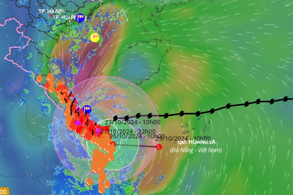
Storm No. 6 with level 11 winds makes landfall in Thua Thien Hue - Da Nang, then turns out to sea
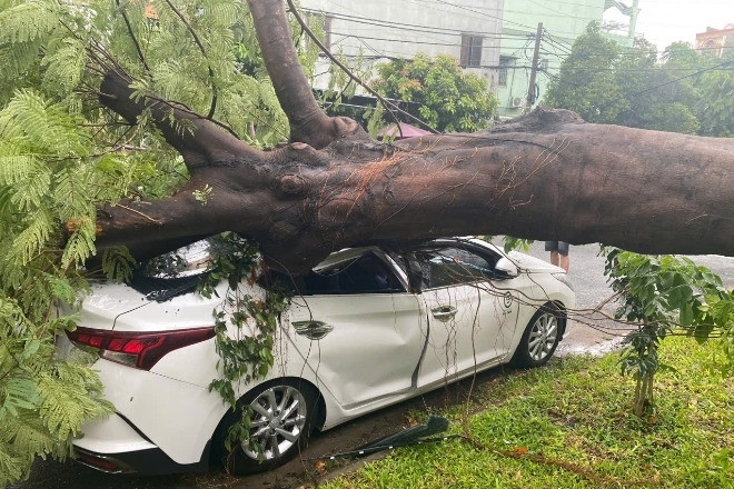
Royal poinciana tree in a school in Ho Chi Minh City was uprooted and crushed a car.

The North is again receiving cold air, with some places having the lowest temperature of 14 degrees.
Source: https://vietnamnet.vn/tphcm-va-dong-nam-bo-mua-tam-ta-do-anh-huong-bao-so-6-2336063.html
![[Photo] The 1st Congress of Phu Tho Provincial Party Committee, term 2025-2030](https://vphoto.vietnam.vn/thumb/1200x675/vietnam/resource/IMAGE/2025/9/30/1507da06216649bba8a1ce6251816820)

![[Photo] General Secretary To Lam, Secretary of the Central Military Commission attends the 12th Party Congress of the Army](https://vphoto.vietnam.vn/thumb/1200x675/vietnam/resource/IMAGE/2025/9/30/9b63aaa37ddb472ead84e3870a8ae825)
![[Photo] Solemn opening of the 12th Military Party Congress for the 2025-2030 term](https://vphoto.vietnam.vn/thumb/1200x675/vietnam/resource/IMAGE/2025/9/30/2cd383b3130d41a1a4b5ace0d5eb989d)
![[Photo] Panorama of the cable-stayed bridge, the final bottleneck of the Ben Luc-Long Thanh expressway](https://vphoto.vietnam.vn/thumb/1200x675/vietnam/resource/IMAGE/2025/9/30/391fdf21025541d6b2f092e49a17243f)
![[Photo] President Luong Cuong receives President of the Cuban National Assembly Esteban Lazo Hernandez](https://vphoto.vietnam.vn/thumb/1200x675/vietnam/resource/IMAGE/2025/9/30/4d38932911c24f6ea1936252bd5427fa)


Comment (0)