
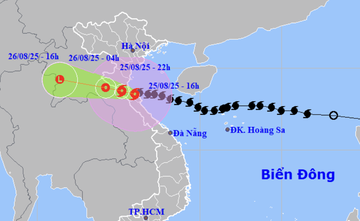
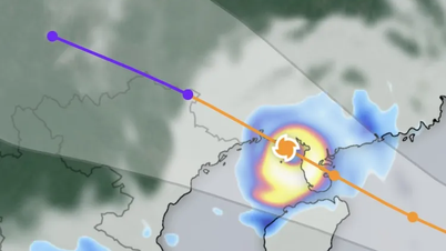
Location and direction of storm No. 5 at 4:00 p.m. on August 25 - Photo: NCHMF
According to the National Center for Hydro-Meteorological Forecasting, this afternoon (13-16h), storm number 5 will hardly move, its intensity will decrease to level 12 (118-133km/h), gusting to level 14.
It is forecasted that in the next 3-6 hours, storm No. 5 will move west-northwest, making landfall in the northern Ha Tinh - southern Nghe An area. The risk of strong winds from storm No. 5 will still persist.
Mr. Nguyen Van Huong - Head of Weather Forecasting Department, Center for Hydro-Meteorological Forecasting - said that by 3:00 p.m. this afternoon, the storm's intensity had decreased to level 12 - 2 levels lower than at 1:00 p.m. this afternoon.
According to Mr. Huong, the reason the storm's wind strength decreased was because when it got close to the shore, the storm encountered friction with the terrain. Along with that, since yesterday, the coastal areas and the Central Coast have had rain, so the sea surface temperature has decreased, reducing the energy supplied to the storm.
Mr. Huong said that in the next 1-3 hours, the storm will move west-northwest, moving inland from southern Nghe An to northern Ha Tinh with a level 11-12 intensity, gusting to level 14-15.
The storm then moved deep into the mainland of Ha Tinh and Nghe An, then moved to upper Laos and gradually weakened.
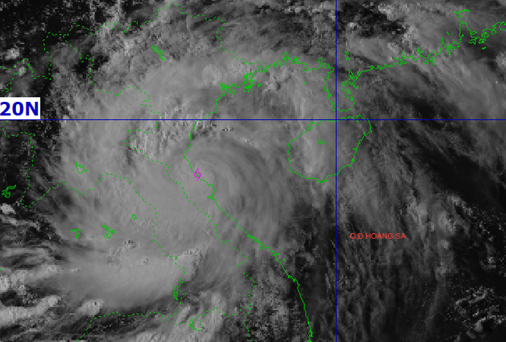
Satellite image of storm No. 5 at 4:00 p.m. on August 25 - Photo: NCHMF
"With such developments, we predict that this afternoon in southern Nghe An - Ha Tinh there will be strong storm winds of level 11-12, gusting to level 14-15, and in northern Nghe An, Thanh Hoa, and northern Quang Tri there will be strong winds of level 8-9.
On the sea from Thanh Hoa to Quang Tri, there will continue to be strong storm winds of level 8-9, near the storm center of level 10-12, gusting to level 14-15, waves still 4-7m high" - Mr. Huong informed.
Mr. Huong also said that the eye of the storm is moving inland, so there will be a period of calm, this does not mean that the wind has weakened, but that the eye of the storm has passed, then the post-storm circulation will continue to cause strong winds again, sometimes even stronger than before. Therefore, people in Nghe An and Ha Tinh need to pay close attention to the phenomenon of wind changes when the eye of the storm enters.
Along with that, heavy rain from Thanh Hoa to Quang Tri will continue. Early tomorrow morning, there will continue to be heavy rain, generally 150 - 300mm, in some places over 500mm, along with the risk of flash floods and landslides in the western mountainous areas from Thanh Hoa to Quang Tri.
Ha Tinh has strong winds of level 9, gusts of level 12
Due to the influence of storm No. 5, in Cam Nhuong (Ha Tinh) there are strong winds of level 9, gusts of level 12; Dien Chau (Nghe An) there are strong winds of level 9, gusts of level 11; Ky Anh (Ha Tinh) there are strong winds of level 8, gusts of level 11...
In the Northern Delta provinces, from Thanh Hoa to Quang Tri, there has been moderate to heavy rain, and in some places very heavy rain over 500mm.
Data from the natural disaster monitoring system shows that in Ha Tinh there is very heavy rain, some places have 300 - 500mm of rain such as Thuong Tuy lake 478mm, Ky Phong 469mm, Ky Lam and Ky Son 426mm, Song Rac lake 373mm, Thach Xuan 360mm, Cam Xuan and Ky Bac 349mm...
Source: https://tuoitre.vn/vi-sao-gio-bao-so-5-giam-hai-cap-truoc-khi-cap-bo-20250825165511479.htm
![[Photo] Solemn opening of the 8th Congress of the Central Public Security Party Committee, term 2025-2030](https://vphoto.vietnam.vn/thumb/1200x675/vietnam/resource/IMAGE/2025/10/4/f3b00fb779f44979809441a4dac5c7df)

![[Photo] General Secretary To Lam attends the 8th Congress of the Central Public Security Party Committee](https://vphoto.vietnam.vn/thumb/1200x675/vietnam/resource/IMAGE/2025/10/4/79fadf490f674dc483794f2d955f6045)


![[Photo] Bustling Mid-Autumn Festival at the Museum of Ethnology](https://vphoto.vietnam.vn/thumb/1200x675/vietnam/resource/IMAGE/2025/10/4/da8d5927734d4ca58e3eced14bc435a3)


![[INFOGRAPHIC] Ricoh GR IV "Street Warrior" returns](https://vphoto.vietnam.vn/thumb/402x226/vietnam/resource/IMAGE/2025/10/4/253d8aa5753b4d9598a544448f716b47)


![[VIDEO] Summary of Petrovietnam's 50th Anniversary Ceremony](https://vphoto.vietnam.vn/thumb/402x226/vietnam/resource/IMAGE/2025/10/4/abe133bdb8114793a16d4fe3e5bd0f12)

![[VIDEO] GENERAL SECRETARY TO LAM AWARDS PETROVIETNAM 8 GOLDEN WORDS: "PIONEER - EXCELLENT - SUSTAINABLE - GLOBAL"](https://vphoto.vietnam.vn/thumb/402x226/vietnam/resource/IMAGE/2025/7/23/c2fdb48863e846cfa9fb8e6ea9cf44e7)


Comment (0)