
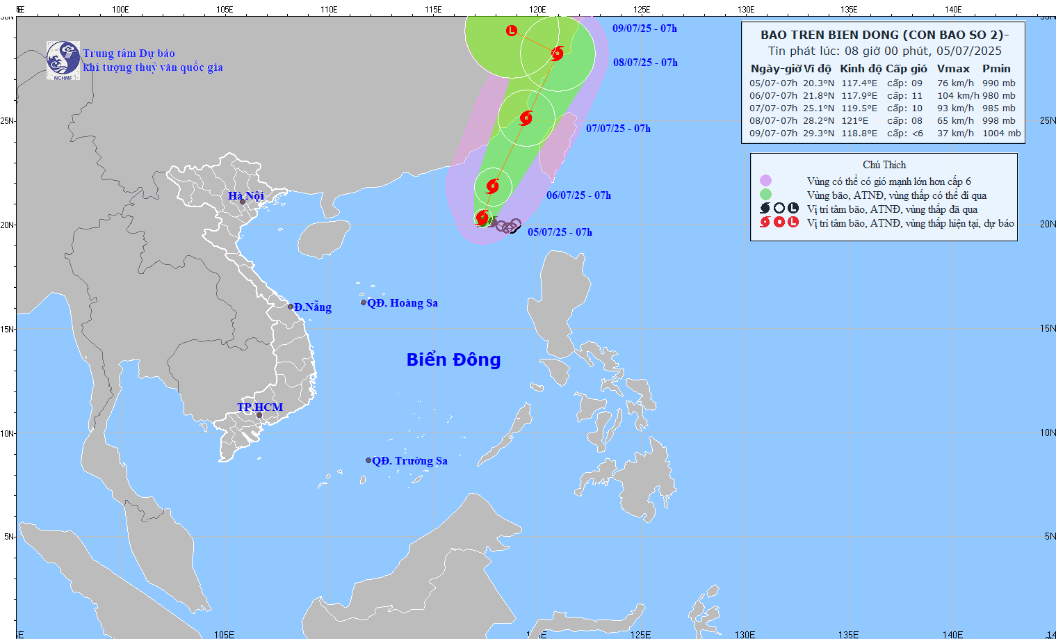
Forecast path of storm No. 2 at 8:00 a.m. July 5.
At 7:00 a.m. on July 5, the center of the storm was at about 20.3 degrees North latitude; 117.4 degrees East longitude; intensity level 8-9 (62-88 km/h), gust level 11. The storm moved slowly in the West Northwest direction, speed about 5-10 km/h.
Forecast at 7am on July 6, storm No. 2 is moving north at a speed of 5-10km/h and is likely to strengthen. The center of the storm is located at 21.8 degrees north latitude - 117.9 degrees east longitude, in the northeastern part of the East Sea. Intensity level 10-11, gust level 13.
Around the morning of July 7, the storm moved in a northeast direction at a speed of about 15km/h, with its center located over the sea of Fujian province (China) and is forecast to continue moving into the mainland of this country.
Storm forecast for the next 24-72 hours.
From the next 72 to 96 hours, storm No. 2 will move in the West Northwest direction at a speed of about 10km/h and gradually weaken into a low pressure area.
Due to the impact of the storm, the northeastern sea area of the North East Sea has stormy rain, strong winds of level 7-8, the area near the storm's center has levels 9-11, gusts of level 13. The sea is rough, with waves 4-6m high. Ships operating in the danger zone are at high risk of being affected by storms, whirlwinds, strong winds and big waves.
NDS
Source: https://baothanhhoa.vn/ap-thap-nhiet-doi-da-manh-len-thanh-bao-so-2-254057.htm

![[Photo] Binh Trieu 1 Bridge has been completed, raised by 1.1m, and will open to traffic at the end of November.](https://vphoto.vietnam.vn/thumb/1200x675/vietnam/resource/IMAGE/2025/10/2/a6549e2a3b5848a1ba76a1ded6141fae)


Comment (0)