
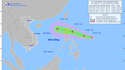
Current status of tropical depression
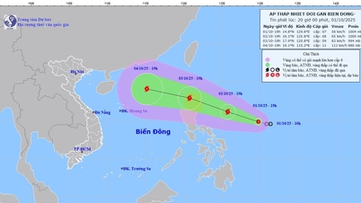
At 7:00 p.m. on October 1, the center of the tropical depression was at about 14.8 degrees North latitude; 129.8 degrees East longitude, in the sea east of the Philippines. The strongest wind near the center of the tropical depression was level 7 (50-61 km/h), gusting to level 9. Moving in the West Northwest direction, speed about 15 km/h.

Tropical depression developments in the next 48 hours
The tropical depression currently operating in the sea east of Luzon Island (Philippines) is likely to strengthen into a storm when entering the East Sea.
7:00 p.m. October 2: The center of the tropical depression is at approximately 16.1°N-125.8°E, in the sea east of Luzon Island. Winds are at level 8, gusting to level 10, moving west-northwest at 15-20km/h and is likely to strengthen into a storm.
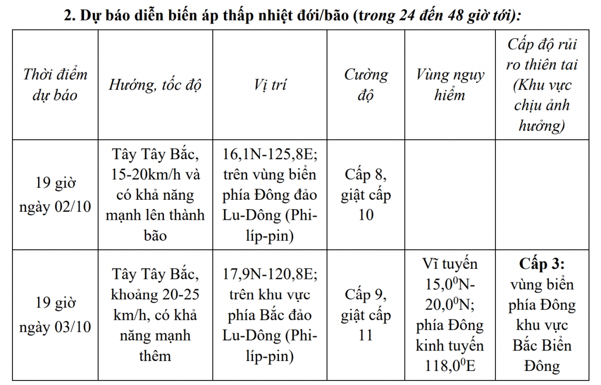
7:00 p.m. October 3: The center of the storm is forecast to be at about 17.9°N-120.8°E, in the area north of Luzon Island. Winds are at level 9, gusting to level 11. The storm continues to move west-northwest at a speed of 20-25km/h, and is likely to strengthen.
Forecast in the next 24-48 hours, the dangerous area in the East Sea is determined from latitude 15.0°N to 20.0°N, east of longitude 118.0°E.
The disaster risk level is warned at level 3, concentrated in the eastern sea area of the North East Sea.
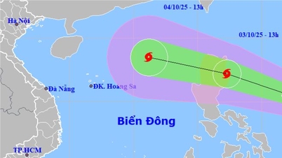
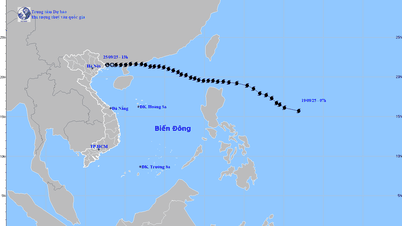
Developmental Alert (Next 48 to 72 Hours)
From the next 48 to 72 hours, the storm will move in the West Northwest direction, about 25km per hour, enter the East Sea and continue to strengthen.
Forecasting the impact of storms
Strong winds and big waves at sea:
From the afternoon of October 3, the sea area east of the North East Sea will have winds gradually increasing to level 6-7; then increasing to level 8, the area near the storm center will have strong winds of level 9-10, gusting to level 12, waves 4.0-6.0m high. The sea will be very rough.
Warning: During October 4-6, the North East Sea area (including Hoang Sa special zone) is likely to be affected by strong winds of level 11-12, gusting to level 15.
Vessels operating in the above mentioned dangerous areas are susceptible to the impact of storms, whirlwinds, strong winds and large waves.
Source: https://baolaocai.vn/ap-thap-nhiet-doi-xuat-hien-gan-bien-dong-co-the-manh-len-thanh-bao-post883430.html
![[Photo] Hanoi morning of October 1: Prolonged flooding, people wade to work](https://vphoto.vietnam.vn/thumb/1200x675/vietnam/resource/IMAGE/2025/10/1/189be28938e3493fa26b2938efa2059e)


![[Photo] Keep your warehouse safe in all situations](https://vphoto.vietnam.vn/thumb/1200x675/vietnam/resource/IMAGE/2025/10/1/3eb4eceafe68497989865e7faa4e4d0e)

![[Photo] President of the Cuban National Assembly visits President Ho Chi Minh's Mausoleum](https://vphoto.vietnam.vn/thumb/1200x675/vietnam/resource/IMAGE/2025/10/1/39f1142310fc4dae9e3de4fcc9ac2ed0)


![[Infographics] An Giang Agriculture 2020-2025: Stable growth, quality transformation](https://vphoto.vietnam.vn/thumb/402x226/vietnam/resource/IMAGE/2025/10/1/bf3a77ba3a0243a697e5253ed4cd6f9c)


Comment (0)