
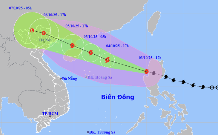
Forecast of location and direction of storm Matmo - Photo: NCHMF
Mr. Hoang Phuc Lam, Deputy Director of the National Center for Hydro-Meteorological Forecasting, said so when reporting on the developments of storm Matmo on the afternoon of October 3.
Storm Matmo may reach level 12-13, gusting to level 14-15 in the East Sea
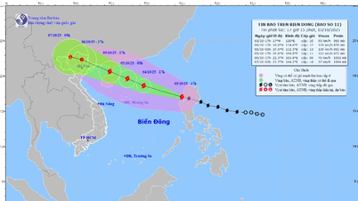
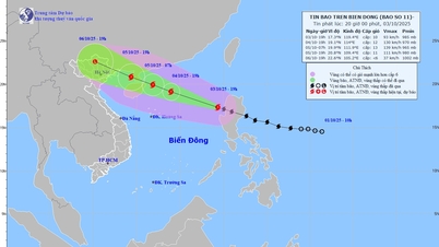
According to Mr. Lam, this afternoon, storm Matmo entered the East Sea and became the 11th storm of the year. The storm is currently at level 10 (89-102km/h), gusting to level 13.
"Currently, the storm is moving quite quickly in the west-northwest direction at a speed of 20-25km/h. Thus, together with storm Bualoi (storm No. 10), storm Matmo has a fairly fast moving speed compared to the average speed of storms in the East Sea and the northwest Pacific region," said Mr. Lam.
According to Mr. Lam, after entering the East Sea, storm Matmo encountered relatively favorable sea surface temperature conditions (about 29 degrees Celsius) and wind shear in the northern area of the East Sea (where the storm's center passed) was quite small, favorable for the storm's development.
In addition, the subtropical high pressure is operating stably, so storm Matmo will continue to move quite fast at a speed of 20-25km/h, sometimes even 30km/h, and the storm will strengthen quite quickly.
The storm's maximum intensity is forecast to reach level 12-13 (118-149km/h), gusting to level 14-15 (i.e. very strong storm) in the east of Leizhou peninsula (China).
From the time the storm moves into the sea area of Guangdong province (China), the direction of the storm depends on the subtropical high pressure and the intensity depends on the terrain friction of the Leizhou peninsula and Hainan island (China). From there, the center gives two possible scenarios.
First (more likely), if the subtropical ridge weakens rapidly and retreats eastward, then Typhoon Matmo will move more northward, meaning the storm will move more overland, quite similar to the path of Typhoon No. 9 Ragasa when it moved along the coast of mainland China.
With this scenario, the storm will weaken more, forecasted from the Loi Chau peninsula to the northern area of Quang Ninh province, the storm will weaken about 2-4 levels compared to the time when the storm is at its strongest.
At that time, the wind in the Gulf of Tonkin was strong at level 9-10, in the mainland of Quang Ninh - Hai Phong it was strong at level 8-9, and there was heavy to very heavy rain in the North. It is also very worrying that the heavy rain caused by storm Matmo may concentrate in the midland and mountainous areas of the North (Tuyen Quang, Lao Cai).

Mr. Hoang Phuc Lam, Deputy Director of the National Center for Hydro-Meteorological Forecasting, informed about the developments of storm Matmo - Photo: C.TUỆ
The North is likely to have heavy rain due to storm Matmo.
The second scenario (less likely but worse impact if it occurs), where the subtropical ridge weakens slightly, causing the storm to track more westward, then the storm travels more over sea.
In this scenario, the storm intensity will not decrease much, so the storm intensity when entering the Quang Ninh area can cause strong winds of level 9-10, gusts of level 12-14, the impact will be extended further south (Quang Ninh - Ninh Binh), the strong wind area will also be deeper inland. Rain will also be heavier but concentrated in the Northern Delta and Thanh Hoa.
"Currently, the National Center for Hydro-Meteorological Forecasting is monitoring the next developments of storm Matmo. It is expected that after entering the East Sea, the storm will reorganize with a stable structure and stronger intensity, so tomorrow's forecasts will be more reliable. Therefore, people need to monitor and update the next storm forecast bulletins," said Mr. Lam.
Mr. Lam also said that this afternoon the meteorological agency issued a warning of heavy rain due to storm Matmo in the North, Thanh Hoa and Nghe An.
It is forecasted that from the night of October 5 to the end of the night of October 7, in the Northern region, Thanh Hoa and Nghe An, there will be heavy to very heavy rain, with common rainfall of 100-200mm, locally over 300mm. The focus of rain in the mountainous and midland areas of the North is generally 150-250mm, locally over 400mm.
With such rainfall, from October 6 to 9 in the North, Thanh Hoa, Nghe An, there is a possibility of a flood, with flood peaks on rivers ranging from alert level 2 to alert level 3.
In addition, it is necessary to guard against the risk of thunderstorms, tornadoes, lightning, strong gusts of wind and heavy rain over 200mm in 3 hours, causing flooding in low-lying areas, urban and industrial areas, flash floods on small rivers and streams, and landslides in mountainous areas.
Source: https://tuoitre.vn/bao-matmo-di-nhanh-rat-manh-tren-bien-dong-20251003171515157.htm
![[Photo] Students of Binh Minh Primary School enjoy the full moon festival, receiving the joys of childhood](https://vphoto.vietnam.vn/thumb/1200x675/vietnam/resource/IMAGE/2025/10/3/8cf8abef22fe4471be400a818912cb85)


![[Photo] Prime Minister Pham Minh Chinh chairs meeting to deploy overcoming consequences of storm No. 10](https://vphoto.vietnam.vn/thumb/1200x675/vietnam/resource/IMAGE/2025/10/3/544f420dcc844463898fcbef46247d16)


Comment (0)