
Hanoi without rain - Sparkling "Full Moon Festival Night"

The Northern Hydrometeorological Station forecasts that on the evening and night of October 3, Hanoi will have no rain, and will be cool; the weather will be favorable for localities to organize a sparkling Mid-Autumn Festival for children across the area. On October 4, Hanoi will have no rain, and will be hot in the afternoon, with the highest temperature of 33-35 degrees Celsius, and cool in the evening and at night. Due to the influence of storm Matmo, Hanoi will have widespread thunderstorms from October 6.
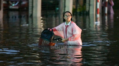
Regarding hydrology, floods on the Tich, Bui, Nhue, Day, Cau, and Ca Lo rivers are slowly receding. At 1 p.m. on October 3, the water level of the Bui River at Yen Duyet was 7.29 m (0.29 m above flood alert level III); the Tich River at Vinh Phuc was 8.15 m (0.15 m above alert level III); the Cau River at Luong Phuc was 7.86 m and the Ca Lo River at Manh Tan was 7.87 m (all below alert level III); the Day River at Ba Tha station was 6.58 m (0.08 m above flood alert level II).
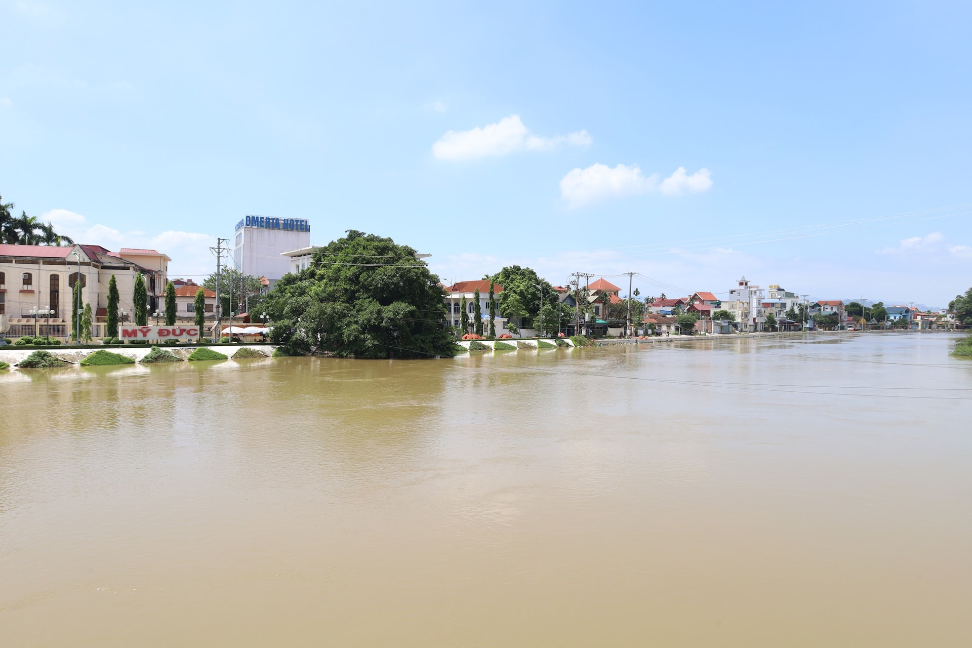
On the night of October 3 and 4, floods on the Bui, Tich, and Day rivers continued to recede but at a very slow rate; the Cau and Ca Lo rivers continued to recede. However, as the water levels of the rivers remained high, low-lying areas along the rivers and sandbanks could be flooded 0.2-0.5m deep, and in some places over 0.5m in the next 2-3 days; it is necessary to guard against the risk of landslides, bank erosion, and loss of safety of key dikes.
Based on the actual water level, the Hanoi City Civil Defense Command ordered to withdraw the level III flood warning on the Cau River from 11:00 a.m. on October 3 in Trung Gia and Da Phuc communes; withdraw the level III flood warning on the Ca Lo River in the communes of Soc Son, Da Phuc, Thu Lam, Phuc Thinh, Quang Minh, Tien Thang, and Noi Bai; withdraw the level I flood warning on the Red River at An Canh on the morning of October 3; and withdraw the level III flood warning on the Nhue River at Dong Quan.
The Hanoi City Civil Defense Command requires communes and wards along the dike to continue to strictly implement measures to ensure the safety of works and riverside activities, and promptly notify people to proactively respond and prevent the risk of landslides and prolonged flooding.
Storm in East Sea, heavy rain on land
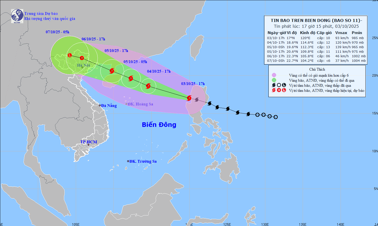
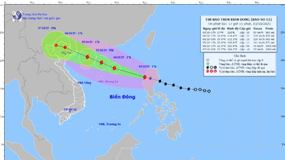
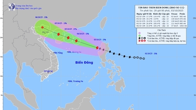
The National Center for Hydro-Meteorological Forecasting said that storm Matmo crossed the northern part of Luzon Island (Philippines) into the East Sea on the afternoon of October 3 and became the 11th storm of 2025. The sea surface temperature is about 29 degrees Celsius, with small wind shear in the northern part of the East Sea, which is favorable for the development of the storm. The subtropical high pressure strongly encroaching to the West makes storm Matmo tend to strengthen, moving quickly at an average speed of 25-30 km/h; the maximum intensity can reach level 12-13, gusting to level 14-15 when in the east of Leizhou Peninsula (evening of October 4).
Since moving into the sea of Guangdong province (China), the subtropical high pressure tongue has weakened, there are two moving scenarios: scenario 1 (probability 70-75%) the storm shifts to the North, moves more on land, strong winds of level 9-10 in the Gulf of Tonkin, level 8-9 on land in Quang Ninh - Hai Phong , heavy rain in the North; scenario 2 (probability 25-30%) the storm moves mainly on the sea, the intensity when entering Quang Ninh - Hai Phong is stronger, winds of level 9-10, gusts of level 12-14, the wind influence extends to the South, heavier rain, strong wind areas deeper inland.
Movement possibilities may change when the storm enters the East Sea, so continuous updates are needed. The Department of Hydrometeorology is currently issuing 4 bulletins/day about storm Matmo, from the afternoon of October 3 when the storm enters the East Sea, it will issue 8 bulletins/day.
The National Center for Hydro-Meteorological Forecasting forecasts that from the night of October 5 to the end of the night of October 7, Hanoi and the northern provinces and cities, Thanh Hoa will have heavy to very heavy rain, with rainfall ranging from 100-200mm, in some places over 300mm; in the mountainous and midland areas of the North, there will be rain from 150-250mm, in some places over 400mm. From October 6 to 9, a flood will appear on the rivers in the North, Thanh Hoa and Nghe An provinces, with the flood peak generally at levels above alert level II to above alert level III.
Source: https://hanoimoi.vn/bao-vao-bien-dong-mien-bac-mua-lon-dien-rong-tu-dem-5-10-718320.html


![[Photo] Students of Binh Minh Primary School enjoy the full moon festival, receiving the joys of childhood](https://vphoto.vietnam.vn/thumb/1200x675/vietnam/resource/IMAGE/2025/10/3/8cf8abef22fe4471be400a818912cb85)
![[Photo] Prime Minister Pham Minh Chinh chairs meeting to deploy overcoming consequences of storm No. 10](https://vphoto.vietnam.vn/thumb/1200x675/vietnam/resource/IMAGE/2025/10/3/544f420dcc844463898fcbef46247d16)


Comment (0)