
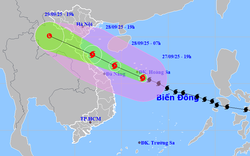
Storm No. 10 is moving West Northwest at a speed of 30-35km/hour and is likely to strengthen.
At 7:00 a.m. on September 28, the center of storm No. 10 was at about 16.9 degrees North latitude, 109.3 degrees East longitude, on the sea of Quang Tri - Hue, about 200km east of Quang Tri with the strongest wind at level 12-13, gusting to level 16.
The storm continues to move in a West-Northwest direction at a speed of about 30km/h and is likely to strengthen.
At 7:00 p.m. on September 28, the storm's center was at about 18.1 degrees North latitude, 106.9 degrees East longitude, in the coastal waters of Nghe An - Quang Tri with the strongest wind at level 12-13, gusting to level 16.
The storm continued to move west-northwest inland and gradually weakened.

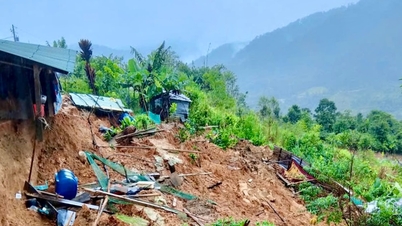
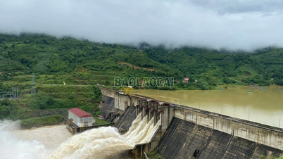
Due to the influence of the storm, in the early morning of September 28, the sea area from Thanh Hoa to Quang Ngai (including Hon Ngu island, Con Co special zone and Ly Son) had winds gradually increasing to level 8-9, the area near the storm's eye had winds of level 10-13, gusting to level 16, waves 5-7m high, and rough seas.
Coastal areas and islands from Ninh Binh to Ha Tinh have storm surges of 0.5-1.5m high, especially from southern Thanh Hoa to northern Ha Tinh where they are 1-1.5m high; the risk of flooding of dykes, coastal roads, and river mouths due to storm surges and waves is very high on the evening and night of September 28.
From the afternoon of September 28, on land from Thanh Hoa to Northern Quang Tri, winds gradually increased to level 6-7, then increased to level 8-9, near the storm center, winds of level 10-12, gusting to level 14; coastal areas from Quang Ninh to Ninh Binh, from Southern Quang Tri to Hue, winds gradually increased to level 6-7, gusting to level 8-9.
From the evening of September 27 to September 30, in the North and the area from Thanh Hoa to Quang Ngai, there is a possibility of widespread heavy rain with total rainfall ranging from 100-300mm, locally over 450mm; in the Northern Delta, South Phu Tho and from Thanh Hoa to northern Quang Tri, the total rainfall is from 200-400mm, locally over 600mm; warning of the risk of rain with intensity greater than 200mm in 3 hours.
Weather in Da Nang regions on the night of September 27 and September 28
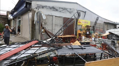
According to the forecast of the Central Hydrometeorological Station, on the night of September 27 and September 28, the plains of Da Nang city will be cloudy, with heavy to very heavy rain and thunderstorms; winds of level 4-5, and early tomorrow morning in some places gusting to level 6-7; during thunderstorms, be on guard against tornadoes, lightning and strong gusts of wind.
The mountainous area north of the city is cloudy, with heavy to very heavy rain, accompanied by dangerous thunderstorms; strong winds level 4-5, sometimes gusting to level 6-7.
Southern mountainous areas: cloudy, heavy to very heavy rain, thunderstorms with tornadoes, lightning; wind level 3-4.
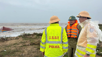
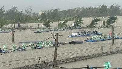
Da Nang sea area has showers and thunderstorms in many places; beware of tornadoes, lightning, strong gusts of wind; visibility less than 6km when raining; wind gradually increases to level 6-7, gusting to level 8-9.
Early morning of September 28, wind increased to level 8-9, gusting to level 11; waves 3-5m high, near the storm center there were waves 5-7m high; sea was very rough.
Hoang Sa Special Zone has stormy rain and severe thunderstorms; strong winds level 8-9, near the storm center level 10-13, gusting to level 16.
Hoang Sa sea area has severe storms, visibility less than 2km when raining; strong winds level 8-9, near the storm center level 10-13, gusting to level 16; waves 4-6m high, near the storm center 6-8m, rough seas.
Source: https://baodanang.vn/bao-so-10-di-chuyen-voi-toc-do-30-35km-gio-huong-ve-vung-bac-trung-bo-3303849.html
![[Photo] General Secretary To Lam chairs the meeting of the Central Steering Committee on preventing and combating corruption, waste and negativity](https://vphoto.vietnam.vn/thumb/1200x675/vietnam/resource/IMAGE/2025/9/29/fb2a8712315d4213a16322588c57b975)
![[Photo] National Assembly Chairman Tran Thanh Man chairs the 8th Conference of full-time National Assembly deputies](https://vphoto.vietnam.vn/thumb/1200x675/vietnam/resource/IMAGE/2025/9/29/2c21459bc38d44ffaacd679ab9a0477c)
![[Photo] Many streets in Hanoi were flooded due to the effects of storm Bualoi](https://vphoto.vietnam.vn/thumb/1200x675/vietnam/resource/IMAGE/2025/9/29/18b658aa0fa2495c927ade4bbe0096df)
![[Photo] General Secretary To Lam attends the ceremony to celebrate the 80th anniversary of the post and telecommunications sector and the 66th anniversary of the science and technology sector.](https://vphoto.vietnam.vn/thumb/1200x675/vietnam/resource/IMAGE/2025/9/29/8e86b39b8fe44121a2b14a031f4cef46)
![[Photo] General Secretary To Lam receives US Ambassador to Vietnam Marc Knapper](https://vphoto.vietnam.vn/thumb/1200x675/vietnam/resource/IMAGE/2025/9/29/c8fd0761aa184da7814aee57d87c49b3)


Comment (0)