
Storm No. 10 has many rare characteristics
According to the National Center for Hydro-Meteorological Forecasting, storm No. 10 has a fast moving speed, averaging 30 - 35 km/hour (twice as fast as normal storms).
The storm's stay on land in Nghe An and Quang Tri provinces lasted from about 10:00-11:00 p.m. on September 28 to 10:00 a.m. on September 29, maintaining its storm intensity for over 12 consecutive hours. Along with that, the storm's circulation caused heavy rain throughout the North and Thanh Hoa to Hue City (in some places, rain was over 500 mm).
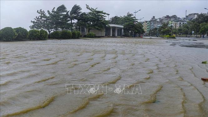
In particular, the storm's strong wind circulation from level 6 or higher stretches across 11/21 coastal provinces, in which the area with strong wind from level 8 stretches from Ninh Binh to Quang Tri, the area of South Ha Tinh - North Quang Tri is the storm's center and is also the area with the strongest wind, commonly level 10 - 11, gusting to level 13 - 14.
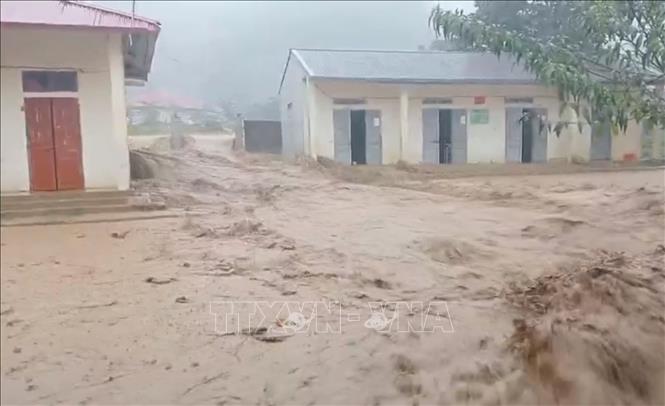
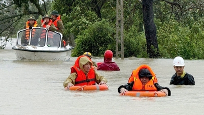
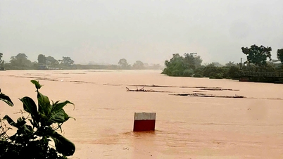
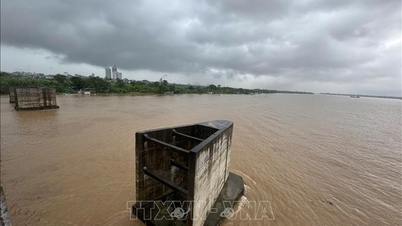
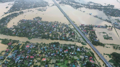
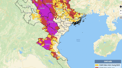
The storm caused heavy rain and floods on many rivers (most of which exceeded alert level 3) such as: Kien Giang (Quang Tri), the upper reaches of Chu River, Ma River (Thanh Hoa), Ca River (Nghe An), Ngan Pho (Ha Tinh) exceeded alert level 3; other rivers from Thanh Hoa to Hue were above alert level 1 to above alert level 2. The risk of landslides, flash floods, and flash floods occurred in most of the Northern provinces.
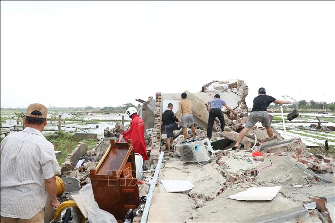
This is one of the most serious and fierce natural disasters, occurring almost simultaneously with especially dangerous types of natural disasters (strong storms, major floods, flash floods, landslides, widespread flooding); severely impacting and affecting most socio-economic activities and infrastructure institutions from the sea to the delta, midlands and mountains.
Experts explain the phenomenon of tornadoes in storms
On the morning of September 29, in addition to the negative impacts of storm No. 10, an unusual weather phenomenon of a tornado appearing in Ninh Binh province caused dozens of casualties and property damage to the people.
Mr. Hoang Phuc Lam, Deputy Director of the National Center for Hydro-Meteorological Forecasting, said that storm Bualoi has a stronger and wider circulation north of the storm center than the southern circulation. This is also a common feature of most storms. Because the northern edge of storms is often subtropical high pressure, this area has a larger air pressure boundary. The difference between the northern air mass and the air mass in the storm center is larger in terms of temperature, pressure and humidity, causing the conflict between the two air masses to cause more thunderstorms and winds to be stronger north of the storm center.
“When Storm Bualoi entered the North Central region, the northern edge of which was located in the Northern Delta, strong thunderstorms occurred. Many large thunderstorms formed on the morning of September 29, accompanied by tornadoes recorded by phone cameras of people in localities such as Ninh Binh, Hung Yen, Hai Phong... These tornadoes are small in scale (a few dozen to a few hundred meters), short in duration (a few minutes to a few dozen minutes) and are usually only recorded in open spaces, such as fields, along highways and are rarely recorded in cities due to narrower spaces," said Mr. Hoang Phuc Lam.
According to Mr. Lam, tornadoes are small in scale, so radars and satellites are almost unable to capture the location and shape of tornadoes. Therefore, measuring, observing and forecasting tornadoes is difficult, and warnings can only be given during thunderstorms where tornadoes are likely to occur.
Mr. Lam also warned that although tornadoes are small in scale, their wind speeds are high, equivalent to those of hurricanes and strong gusts of wind in thunderstorms. Therefore, there is a lot of damage to people, property, trees, and objects swept away by tornadoes, causing damage along the path of the tornado.
Discussing further on this issue, Mr. Mai Van Khiem, Director of the National Center for Hydro-Meteorological Forecasting, said that in essence, a tornado is also a storm, but on a smaller scale than a storm in terms of size, space, and duration...
“For storms that also form vortices but last for a long time, on a large spatial scale, satellites, radars, and models can calculate the shape and structure of the storm, then it can be predicted. As for thunderstorms and tornadoes that occur in a narrow, small range, they can only be observed with the naked eye,” said Mr. Mai Van Khiem.
Currently, meteorological science only warns of the possibility of tornadoes, waterspouts, and hail in conditions of strong thunderstorm clouds, formed in a hot, humid, and highly unstable environment. Current science can only give warnings, but cannot predict the location, intensity, or development of tornadoes and waterspouts.
Review of the developments of storm number 10
On the evening of September 26, storm Bualoi entered the eastern sea of the central East Sea, becoming the 10th storm in 2025 with a strong intensity of level 12, gusting to level 15, moving in the West Northwest direction at a fast speed, averaging about 35 km/hour.
After entering the East Sea, the storm maintained its intensity, direction and speed. On September 27, the storm slowed down to a speed of 30 - 35 km/h. On the morning of September 28, the storm's speed decreased to about 25 km/h.
On the night of September 28, storm No. 10 entered the Ha Tinh - Northern Quang Tri area, the storm intensity decreased to level 11, gusts of level 14, the storm continued to move in the West Northwest direction at a speed of 20 - 25 km/hour. On the morning of September 29, the storm moved into the Nghe An - Central Laos border area, the intensity decreased to level 8, gusts of level 10. At noon on September 29, the storm moved to the Upper Laos area, weakened into a tropical depression, then became a low pressure area.
Due to the influence of storm No. 10, at Co To station (Quang Ninh), there are strong winds of level 7, gusts of level 9; Bach Long Vi station (Hai Phong) strong winds of level 8, gusts of level 9; Hon Ngu station (Nghe An) strong winds of level 10, gusts of level 14; storm surge is 1.6 m high; Con Co station (Quang Tri) strong winds of level 10, gusts of level 11... On the mainland along the coast of the provinces from Quang Ninh - North Quang Tri, there are strong winds of level 6-9, gusts of level 10-12, near the storm center, level 10-11, gusts of level 14, at Dien Chau station (Nghe An) strong winds of level 11, gusts of level 13; Hoanh Son station (Ha Tinh) strong winds of level 11, gusts of level 14; Ky Anh station (Ha Tinh) strong winds of level 10, gusts of level 12.
From the night of September 26 to 28, in the area from Hue City to Da Nang, the rainfall was generally 200 - 450 mm, in some places over 500 mm such as: Hong Trung (Hue City) 627 mm, Huong Nguyen (Hue City) 619 mm, Suoi Luong (Da Nang) 409 mm...
From the night of September 26 to 29, the area from Ha Tinh to Quang Tri from 200 - 400 mm, some places over 450 mm such as: Trang Market (Ha Tinh) 578 mm, Son Hong 1 (Ha Tinh) 517 mm, Huong Son (Quang Tri) 541 mm, Vuc Tron Lake (Quang Tri) 523 mm...
From the night of September 26 to 29, the area from Thanh Hoa to Nghe An will have rainfall from 300 - 500 mm, some places over 550 mm such as Nong Truong 15 (Nghe An) 836 mm, Yen Thuong (Nghe An) 672 mm, Xuan Binh (Thanh Hoa) 739 mm, Xuan Le (Thanh Hoa) 664 mm...
From September 28 to 29, the Northern Delta, Phu Tho, Southern Son La, Lao Cai areas generally have 70 - 120 mm, especially in Southern Phu Tho and Southern Son La areas, it is 100 - 250 mm, some places have over 250 mm such as: Van Mai (old Hoa Binh) 404 mm, Lung Van (old Hoa Binh) 365 mm, Muong Do1 (Son La) 339 mm...
It is forecasted that from the morning of September 29 to September 30, in the area from Thanh Hoa to Ha Tinh, the Northern Delta, Phu Tho, the southern part of Son La and Lao Cai provinces, there will be heavy to very heavy rain with common rainfall of 100 - 200 mm, locally over 350 mm; other places in the North will have moderate to heavy rain with common rainfall of 70 - 120 mm, locally over 200 mm. Warning of the risk of heavy rain (>200 mm/3 hours).
Source: https://baotintuc.vn/xa-hoi/chuyen-gia-khi-tuong-giai-giach-hien-tuong-xoay-loc-trong-bao-so-10-20250929220728328.htm
![[Photo] General Secretary To Lam receives US Ambassador to Vietnam Marc Knapper](https://vphoto.vietnam.vn/thumb/1200x675/vietnam/resource/IMAGE/2025/9/29/c8fd0761aa184da7814aee57d87c49b3)

![[Photo] The 1st Congress of Phu Tho Provincial Party Committee, term 2025-2030](https://vphoto.vietnam.vn/thumb/1200x675/vietnam/resource/IMAGE/2025/9/30/1507da06216649bba8a1ce6251816820)

![[Photo] General Secretary To Lam, Secretary of the Central Military Commission attends the 12th Party Congress of the Army](https://vphoto.vietnam.vn/thumb/1200x675/vietnam/resource/IMAGE/2025/9/30/9b63aaa37ddb472ead84e3870a8ae825)
![[Photo] Solemn opening of the 12th Military Party Congress for the 2025-2030 term](https://vphoto.vietnam.vn/thumb/1200x675/vietnam/resource/IMAGE/2025/9/30/2cd383b3130d41a1a4b5ace0d5eb989d)


![[Photo] General Secretary To Lam attends the ceremony to celebrate the 80th anniversary of the post and telecommunications sector and the 66th anniversary of the science and technology sector.](https://vphoto.vietnam.vn/thumb/1200x675/vietnam/resource/IMAGE/2025/9/29/8e86b39b8fe44121a2b14a031f4cef46)


Comment (0)