
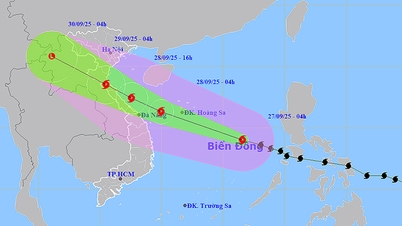
The eye of the storm is moving along the southern coast of China towards Leizhou Peninsula (China) and Mong Cai ( Quang Ninh , Vietnam).
Updated at 6:00 p.m. on September 24, the center of storm No. 9 was at about 21.6 degrees North latitude - 111.7 degrees East longitude, about 410km east of Mong Cai (Quang Ninh).
At this time, the storm has weakened to level 13, gusting to level 16, while on the morning of September 24, it still maintained wind speed at level 15-16, gusting above level 17.
 according to the model of the National Center for Hydro-Meteorological Forecasting, afternoon of September 24")
According to Mr. Hoang Phuc Lam, Deputy Director of the National Center for Hydro-Meteorological Forecasting, the storm is still moving steadily westward at a speed of about 20km/hour. It is forecasted that by early tomorrow morning, September 25, the storm will pass north of the Loi Chau peninsula into the northern area of the Gulf of Tonkin, about 180km from Mong Cai.
Due to the long period of friction with mainland Guangdong (China), when entering the Gulf of Tonkin, the storm will only be at level 10-11, gusting to level 13-14. According to Mr. Hoang Phuc Lam, the eye of the storm is forecast to make landfall in Quang Ninh and Hai Phong on September 25, with the focus being Quang Ninh, at the time of landfall the wind will only be at level 8-9.
Although the storm is no longer as dangerous when it hits Vietnam as it was when it swept across southern China, the change that needs to be noted is that the forecast rainfall will increase compared to the previous forecast.
The meteorological agency said that from the night of September 24 to the end of the night of September 26, the North, Thanh Hoa and Nghe An will have widespread rain of 150-300mm, locally over 450mm, with a very high risk of flooding, flash floods and landslides.
From September 25 to 27, many major rivers in the North such as Thao River, Lo River, Thai Binh River, Hoang Long River, Buoi River and the upper Ma River may experience floods, some places reaching alert level 2-3.
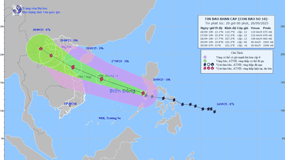
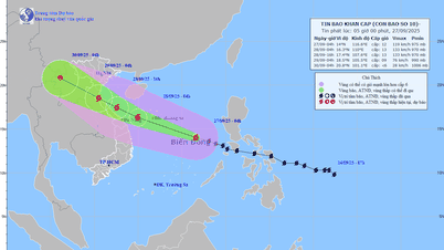
Along with storm No. 9 (Ragasa), a new storm has appeared offshore, with the international name Bualoi (nominated by Thailand). The National Center for Hydro-Meteorological Forecasting warned that around the night of September 26, storm Bualoi will enter the East Sea and become storm No. 10 in 2025.

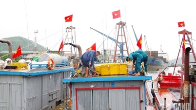
On the afternoon of September 24, the National Civil Defense Steering Committee sent a document to the People's Committees of 21 coastal provinces and cities from Quang Ninh to An Giang, requesting the implementation of early response measures to storm Bualoi. The document, signed by Acting Minister of Agriculture and Environment Tran Duc Thang, requested localities to regularly monitor and promptly notify ships to proactively avoid, prepare rescue forces and maintain on-duty, and regularly report to the steering committee.
According to international forecast models, the storm's trajectory and intensity are still scattered, but it is likely to directly impact the North East Sea, affecting the Central and Northern regions of our country. From the evening and night of September 26, the Northeast and central East Sea will gradually have winds of level 6-7, then increase to level 8-9, near the storm's center, winds of level 10-11, gusts of level 14, waves of 5-7m high, and rough seas.
On September 24, the Department of Agriculture and Environment of Ho Chi Minh City sent a document to the City Border Guard Command, People's Committees of coastal wards and communes, island communes, special zones and related agencies on proactively responding to storm No. 10 (Bualoi) near the East Sea.
Implementing Official Dispatch No. 04/BCĐ-BNNMT of the National Civil Defense Steering Committee on proactively responding to storm Bualoi near the East Sea, the Department of Agriculture and Environment requests units and localities to closely monitor warning bulletins and forecasts of the development of storm Bualoi near the East Sea through the bulletins of the Southern Hydrometeorological Station.
The People's Committees of coastal wards, communes, island communes and special zones, the City Border Guard Command, the Department of Fisheries and Fisheries Surveillance, and the City Coastal Information Station must regularly inform vessels and boats operating at sea about the developments of storm Bualoi near the East Sea to have appropriate plans for production and exploitation of aquatic products; at the same time, organize monitoring, counting and statistics of the number of vessels operating in the affected area; ensure communication with vessel owners to guide and promptly handle incidents; be ready to deploy plans to ensure safety for people and vessels operating at sea in the face of storm developments; be ready with forces, vehicles and equipment to carry out search and rescue work when situations arise.
THANH HIEN
Source: https://www.sggp.org.vn/bao-so-9-se-do-bo-quang-ninh-hai-phong-san-sang-ung-pho-voi-bao-so-10-post814534.html
![[Photo] Prime Minister Pham Minh Chinh attends the groundbreaking ceremony of two key projects in Hai Phong city](https://vphoto.vietnam.vn/thumb/1200x675/vietnam/resource/IMAGE/2025/9/27/6adba56d5d94403093a074ac6496ec9d)


Comment (0)