
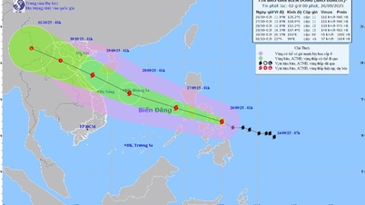
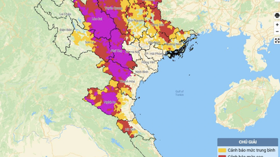
On the afternoon of September 21, a series of meteorological agencies raised the warning level of Ragasa storm to maximum hurricane level (full storm scale). This is the strongest super storm to appear in the East Sea in many years, the eye of the storm will make landfall from Quang Ninh to Ha Tinh .
The National Center for Hydro-Meteorological Forecasting said that as of 5 p.m. on September 21, the center of storm Ragasa was at about 18.6 degrees North latitude and 125.8 degrees East longitude, only 370km east of Luzon Island (Philippines).
On the afternoon of September 21, the storm intensity reached level 16 (184-201 km/h), gusting over level 17. The Philippine Meteorological Agency raised the warning to level 3 - the highest level for the storm's impact. At the same time, a series of international meteorological agencies raised the level of the largest "super storm" since the beginning of 2025 to this point.

According to the Vietnam National Center for Hydro-Meteorological Forecasting, around the evening of September 22, super typhoon Ragasa will enter the East Sea (earlier than previously forecast), becoming the ninth typhoon this year.
Currently, the storm is moving rapidly in the West-Northwest direction, at a speed of about 20km/h. On September 22 and 23, the storm's intensity may reach a maximum of level 16-17, gusting above level 17, equivalent to the strongest level of storm Yagi (storm No. 3) in September 2024.
By September 24, the storm may weaken when it enters the coastal area of Guangdong (China), then enter the Gulf of Tonkin in the early morning of September 25 with an intensity of level 12-14, gusting to level 15-16. On the afternoon of September 21, most domestic and foreign meteorological agencies added warnings that the trajectory of storm No. 9 will head towards mainland Vietnam. The direct focus of impact is the coastal area from Quang Ninh to Ha Tinh.

According to international and domestic scenarios, this is a super typhoon with a very wide circulation and extremely strong intensity in the East Sea. The Japanese Meteorological Agency forecasts Ragasa's wind speed to reach 195km/h (level 16), while China forecasts 223km/h (above level 17), and Hong Kong forecasts up to 240km/h (above level 17).
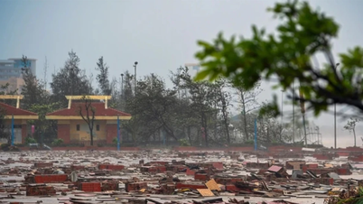
On the afternoon of September 21, Mr. Hoang Phuc Lam, Deputy Director of the National Center for Hydro-Meteorological Forecasting, noted the possibility of a worse scenario: if the storm moves lower and weakens less when entering the East Sea, the impact of storm winds and large waves in the Gulf of Tonkin and along the coast from Thanh Hoa to Hue will be stronger, and the accompanying heavy rain will also be more serious.

Mr. Hoang Phuc Lam also said that the first cold air mass of the season moving to the North of our country could make the storm's trajectory and intensity more complicated, causing the forecast for the next 3 days to still have a large dispersion.
The National Center for Hydro-Meteorological Forecasting forecasts that from September 23, strong winds of level 10-14 will cover the North East Sea, the area near the storm center will reach level 15-17, gusts above level 17, waves over 10m high, and rough seas. From September 24, the Gulf of Tonkin will have strong winds of level 11-13, gusts of level 15-16. On the morning of September 25, coastal winds from Quang Ninh to Ha Tinh will gradually increase to level 9-10, the area near the storm center will reach level 12-14, gusts of level 15-16, waves 4-7m high.

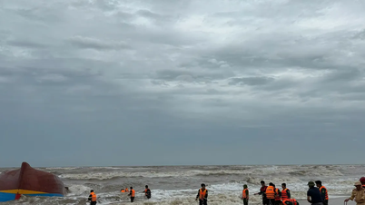
Mr. Hoang Phuc Lam advised localities and fishermen to be especially cautious of strong winds, big waves at sea, and the risk of storms near the coast when the storm is still 300-400km from the mainland (like what happened in Ha Long Bay, capsizing the tourist boat Vinh Xanh in July 2025).
Source: https://www.sggp.org.vn/chuyen-gia-khi-tuong-bao-so-9-co-the-do-bo-tu-quang-ninh-den-ha-tinh-post814060.html
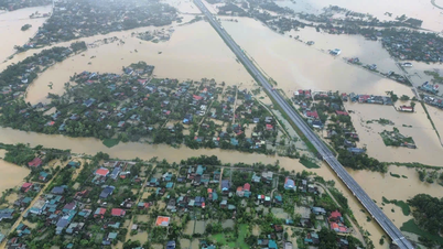
![[Photo] Many streets in Hanoi were flooded due to the effects of storm Bualoi](https://vphoto.vietnam.vn/thumb/1200x675/vietnam/resource/IMAGE/2025/9/29/18b658aa0fa2495c927ade4bbe0096df)
![[Photo] General Secretary To Lam, Secretary of the Central Military Commission attends the 12th Party Congress of the Army](https://vphoto.vietnam.vn/thumb/1200x675/vietnam/resource/IMAGE/2025/9/30/9b63aaa37ddb472ead84e3870a8ae825)

![[Photo] General Secretary To Lam receives US Ambassador to Vietnam Marc Knapper](https://vphoto.vietnam.vn/thumb/1200x675/vietnam/resource/IMAGE/2025/9/29/c8fd0761aa184da7814aee57d87c49b3)

![[Photo] General Secretary To Lam attends the ceremony to celebrate the 80th anniversary of the post and telecommunications sector and the 66th anniversary of the science and technology sector.](https://vphoto.vietnam.vn/thumb/1200x675/vietnam/resource/IMAGE/2025/9/29/8e86b39b8fe44121a2b14a031f4cef46)


![[Photo] National Assembly Chairman Tran Thanh Man chairs the 8th Conference of full-time National Assembly deputies](https://vphoto.vietnam.vn/thumb/1200x675/vietnam/resource/IMAGE/2025/9/29/2c21459bc38d44ffaacd679ab9a0477c)


Comment (0)