
.jpg)
Strong storm intensity, wide range of influence
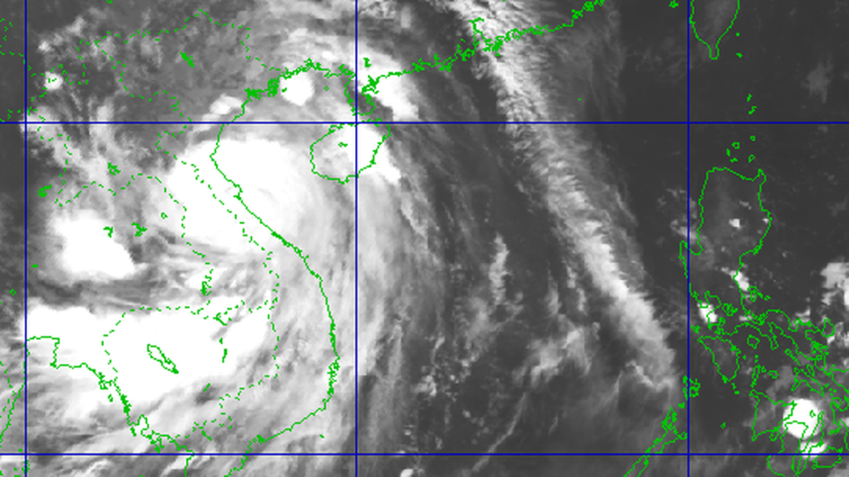
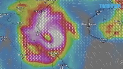
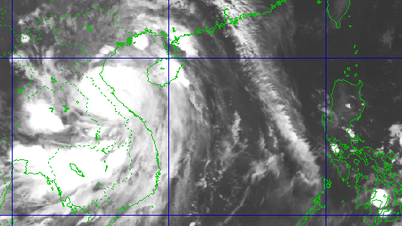
According to the Central Hydrometeorological Station, at 10:00 a.m. on September 27, the center of the storm was at about 14.5 degrees North latitude; 114.9 degrees East longitude, about 370km East Southeast of Hoang Sa special zone. The strongest wind near the center of the storm was level 11-12 (103-133km/h), gusting to level 15. Moving in the West Northwest direction at a speed of about 35km/h.
According to assessment, this is a very fast moving storm (nearly twice the average speed), strong storm intensity, wide range of influence, can cause combined impacts of many types of natural disasters such as strong winds, heavy rains, floods, flash floods, landslides and coastal flooding.
Storm forecast (next 24-72 hours): By 10am on September 28, the storm will move West Northwest, at a speed of 30km/h, with the possibility of strengthening, located at 16.9°N - 108.8°E (on the sea area of South Quang Tri, Quang Ngai, about 120km East Northeast of Hue city), level 12 - 13, gust 16. Dangerous area: Latitude 12.5N - 20.0N; West of longitude 117.0E. The affected area is the North and Central East Sea (including Hoang Sa special zone); the sea area from Ha Tinh to Quang Ngai.
At 10:00 p.m. on September 28, the storm moved to the West Northwest, at a speed of about 20-25 km/h, at 18.0°N - 106.6°E, on the coastal waters from Nghe An - Quang Tri, level 12 gusts 15. Dangerous area: North of latitude 14.0N; West of longitude 111.5E. Affected areas: Coastal mainland areas from Nghe An to North of Quang Tri (natural disaster risk level: level 4); western sea areas of the North East Sea (including Hoang Sa special zone), northwest of the central East Sea area, from Thanh Hoa to Quang Ngai (including Hon Ngu island, Con Co special zone and Ly Son) and North of Bac Bo Gulf (including Bach Long Vy special zone, Van Don, Co To, Cat Hai and Hon Dau island); mainland areas from Ninh Binh to Hue city (natural disaster risk level: level 3)

At 10:00 on September 29, the storm moved to the West Northwest, at a speed of 20 - 25km/h, weakening into a tropical depression; located at 19.2°N - 104.3°E (on the Vietnam-Laos border area), level 8 gusts 10. Dangerous area: North of latitude 15.5N; West of longitude 108.5E. Affected area from Thanh Hoa to Quang Ngai (including Hon Ngu island, Con Co special zone and Ly Son) and North of Bac Bo Gulf (including Bach Long Vy special zone, Van Don, Co To, Cat Hai and Hon Dau island), mainland area from Ninh Binh to Hue city (natural disaster risk level: level 3). At 22:00 on September 29, the storm gradually weakened into a low pressure area; located at 20.3°N - 102.3°E in the Upper Laos area.
Forecast of storm impact at sea: The North and Central East Sea (including Hoang Sa special zone) has strong winds of level 8 - 9, the area near the storm's eye has winds of level 10 - 13, gusts of level 16, waves from 6.0 - 8.0m high, the area near the storm's eye is 8.0 - 10.0m, the sea is very rough.
From the evening of September 27, the sea area of Da Nang city gradually increased to level 6 - 7, gusting to level 8 - 9, waves 3.0 - 5.0m high, rough seas. From the early morning of September 28, the wind increased to level 8 - 9, the area near the storm center passed level 10 - 13, gusting to level 16, waves 5.0 - 7.0m high, rough seas.
Vessels operating in the above mentioned dangerous areas are susceptible to the impact of storms, whirlwinds, strong winds and large waves.
On the city's coastal mainland on September 28, there will be strong winds of level 5, level 6, gusting to level 7 - 8 (wind levels can cause trees to shake, making it difficult to participate in traffic, especially on coastal routes).
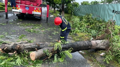
From September 27 to September 28, in localities of Da Nang city, there will be moderate rain, heavy rain, and in some places very heavy rain and thunderstorms. The total rainfall for the entire period is commonly 100 - 250mm, in some places over 350mm. During thunderstorms, it is necessary to be on guard against tornadoes, lightning and strong gusts of wind.
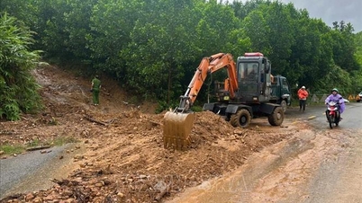
According to the landslide warning at 11:00 a.m. on September 27, in the next 3 hours, there is a risk of flash floods on small rivers and streams in mountainous areas; landslides on steep slopes, and land subsidence in many communes and wards of Da Nang city, specifically:
Risk of flash floods from high to very high: Hoa Bac, Hoa Hiep Bac, Hoa Hiep Nam (belonging to Hai Van ward), Binh Phu (Thang Phu commune);
Risk of landslides from high to very high: Hoa Bac, Hai Van pass, Hoa Hiep Bac, Hoa Hiep Nam (belonging to Hai Van ward), Hoa Hai (Ngu Hanh Son ward), Binh Phu (Thang Phu commune), Tien Phong (Tien Phuoc commune)
Flood warning: In the next 3 hours, there is a risk of flooding on roads and low-lying areas in the following wards (communes): Hoa Cuong, Thanh Khe, Hai Chau, An Hai, Cam Le, Hoa Xuan, Tam Ky, Ban Thach, Huong Tra, Tay Ho. Flooding is likely to occur from now until 1:00 p.m. on September 27. Flood depth is generally from 0.1-0.2m; in some places it is higher from 0.3 - 0.5m.
Rainfall and water level developments: From 7:00 p.m. on September 26 to 11:00 a.m. on September 27, in Da Nang city, there was rain, moderate rain, and some places had heavy to very heavy rain such as: Suoi Luong (Hai Van) 128 mm; Phuoc Ha reservoir (Thang Phu) 118 mm; Ho Do reservoir (Thang Phu) 112 mm; Hoa Xuan (Hoa Xuan commune) 109 mm; Hoa Hai (Ngu Hanh Son) 108 mm; Hoa Quy (Ngu Hanh Son) 106 mm; Hoa Phuoc (Hoa Xuan) 102 mm.
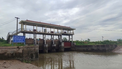
Water levels on all rivers are low, below alert level I. Most reservoirs are below average water level, ensuring safety.
Regarding production situation, the planting area is 43,639 hectares, of which 39,538 hectares have been harvested.
Currently, aquaculture is stable, no epidemics have occurred. Of which, the aquaculture area in ponds (currently being raised): 1,740 hectares, including aquaculture in brackish water ponds: 1,520 hectares (shrimp farming 1,150 hectares, farming of other objects such as crabs, fish, snails, etc. 220 hectares); aquaculture in freshwater ponds: 150 hectares). The aquaculture area in cages (currently being raised) is about 2,380 cages, of which: brackish water cage farming is about 1,850 cages; freshwater cage farming is about 530 cages.
Areas at risk of rain and storms: Pond farming 1,670 hectares; cage farming about 2,380 cages. The Department of Seas, Islands and Fisheries issued Official Dispatch No. 774/CCBĐTS-NVTS dated August 19, 2025 on the implementation of management and guidance on aquaculture during the rainy and stormy season. Accordingly, people have been instructed on measures to prevent and combat rain and storms.
Actively call on ships to return to safety
Regarding the situation of vessels, the City Border Guard Command has implemented the instructions in the documents of the Command and the Chairman of the City People's Committee. In particular, the coastal units broadcast news about the location and development of the storm to fishing vessels operating at sea, and called for instructions for fishing vessels and vehicles operating to proactively avoid and move out of the storm's affected area, and have a plan for their journey and production to ensure safety.

Direct coastal border stations to count and count the number of people and boats operating at sea, especially offshore fishing boats.
Standing forces and vehicles are ready to carry out search and rescue missions when situations arise. Data up to 11:00 a.m. on September 27: Total number of fishing boats in Da Nang city: 4,148/21,000 workers; total number of fishing boats operating at sea: 200 boats/3,371 workers. Of which, coastal areas: 88 boats/185 workers; offshore areas: 34 boats/211 workers; Hoang Sa: 12 boats/115 workers; Truong Sa: 66 boats/2,860 workers. The City Border Guard Command has fired signal flares to warn of the storm and organized a sea ban until the storm dissipates. Currently, they are continuing to monitor and contact the owners of the boats to call for shelter from the storm.
The City Border Guard Command has also prepared 8 ships, 14 boats, and 30 vehicles to respond to storm No. 10.
The City Civil Defense Command has organized serious shifts, closely monitored the storm's developments and weather conditions, issued documents to direct units to respond to natural disasters; regularly transferred information about natural disasters via Zalo groups, and posted information about natural disasters on the Facebook page of Da Nang Natural Disaster Prevention Information.
Plan to evacuate more than 210,000 people in dangerous areas
The City Civil Defense Command said that currently, localities are continuing to closely monitor the storm's developments to proactively evacuate people when necessary. Estimated evacuation data in the event of a strong storm in the city: The total number of people expected to be evacuated is 210,014 (of which, 92,041 are interleaved, 117,974 are concentrated), the expected evacuation areas are schools, churches; pagodas; cultural houses; community activity houses; solid constructions concentrated in the locality.
According to Chairman of Hai Van Ward People's Committee Nguyen Thuc Dung, the locality chaired the meeting and implemented the telegram of the City People's Committee. The locality divided into 3 groups in key areas to carry out propaganda work and support the people. Small boats have been brought to the assembly point. Locations at risk of landslides have also made plans to evacuate when ordered, especially locations in Hoa Bac commune (old).
Chairman of Hoa Khanh Ward People's Committee Huynh Anh Vu said that the locality has proactively coordinated with armed units to proactively dispatch troops to serve the evacuation and support people. The locality has also assigned comrades to stand guard, especially in high-risk areas such as Me Suot and Nui So. In the Me Suot street area, units have mobilized 250 soldiers to support and evacuate about 4,000 people to safer locations.
According to the People's Committee of Tien Phuoc commune, the locality has surveyed dangerous areas and is ready to evacuate people.
Director of the Department of Construction Nguyen Ha Nam said that the unit has issued documents to direct and implement. On the routes managed by the unit, forces have been organized to handle and clear the route when incidents occur; units are required to patrol the roads and coordinate with localities to prepare timely mobilization plans. For wards and communes with the function of managing university, inter-commune and inter-village routes, it is necessary to develop plans, monitor and patrol the roads to be on duty and handle, ensuring safety for the people.
Regarding drainage, the unit has implemented plans. There are 23 urban wards and a group has been established to implement plans to prevent flooding. During the rainy season, the department has also implemented plans, especially dredging and clearing; requesting localities to mobilize people to proactively clear sewers and drainage manholes to prevent flooding.
In its role as infrastructure manager, the department has organized teams on duty at pumping stations to ensure maximum operation. Along with that, the department has also deployed documents related to high-rise buildings and high-rise construction equipment for inspection, requiring compliance with the city's instructions; there must be solutions to support and reduce height, to avoid falls and unfortunate incidents.
.jpg)
Concluding the meeting, Standing Vice Chairman of the City People's Committee Ho Ky Minh emphasized that the storm is moving quickly, and will approach the city in the early morning of September 28, then move in a West-Northwest direction. This evening, it is expected that the city will have rain, and in the early morning of September 28, there will be wind and heavy rain. Therefore, the Border Guard is requested to continue contacting ships at sea to call for shelter from the storm to a safe place, especially the 4 ships in danger. Localities such as Hai Van, Lien Chieu, Ba Na, Hoa Vang, Hoa Tien, Tien Phuoc, Thang Phu... are at risk of flooding and landslides, so it is requested that the Chairmen of the People's Committees of communes and wards proactively plan to evacuate people to a safe place, which must be completed by 5:00 p.m. on September 27 at the latest. For urban wards, the Standing Vice Chairman of the City People's Committee requested the Department of Construction to be on duty at pumping stations, and ward People's Committee leaders to remind people to proactively remove obstacles at manholes to handle flooding.
The Chairmen of the People's Committees of wards and communes must proactively let students take a day off on Monday (September 29). Local media agencies must continuously update warnings and support localities when situations arise. Leaders of agencies and units, especially the armed forces, must proactively coordinate and support localities when situations arise. Localities must make every effort to respond to the storm and promptly handle situations that arise, with the ultimate goal of ensuring people's lives and property.
Source: https://baodanang.vn/da-nang-tap-trung-ung-pho-voi-bao-so-10-bao-bualoi-3303840.html
![[Photo] The 4th meeting of the Inter-Parliamentary Cooperation Committee between the National Assembly of Vietnam and the State Duma of Russia](https://vphoto.vietnam.vn/thumb/1200x675/vietnam/resource/IMAGE/2025/9/28/9f9e84a38675449aa9c08b391e153183)

![[Photo] High-ranking delegation of the Russian State Duma visits President Ho Chi Minh's Mausoleum](https://vphoto.vietnam.vn/thumb/1200x675/vietnam/resource/IMAGE/2025/9/28/c6dfd505d79b460a93752e48882e8f7e)
![[Photo] Joy on the new Phong Chau bridge](https://vphoto.vietnam.vn/thumb/1200x675/vietnam/resource/IMAGE/2025/9/28/b00322b29c8043fbb8b6844fdd6c78ea)


Comment (0)