
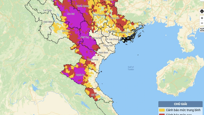
On September 11, Hai Duong Hydrometeorological Station said that the water level of some rivers in the province has reached alarm level 3.
Specifically, the water level of the Thai Binh River at the Cat Khe Hydrological Station (Nam Sach) reached alarm level 3 (5.00m) at 10:00 p.m. on September 10; at the Phu Luong Hydrological Station (Hai Duong City) reached alarm level 3 at 5:00 a.m. on September 11; the water level of the Kinh Mon River at the An Phu Hydrological Station (Kinh Mon) reached alarm level 3 at 4:00 a.m. on September 11. Other rivers are also likely to reach alarm level 3 this morning.

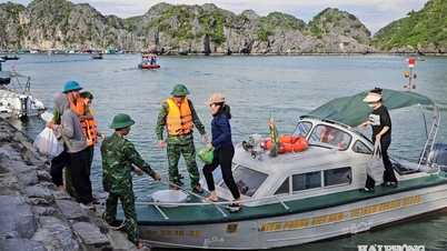
Authorities assist people in evacuation.
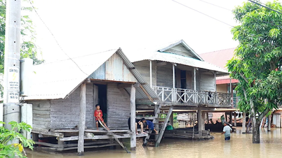
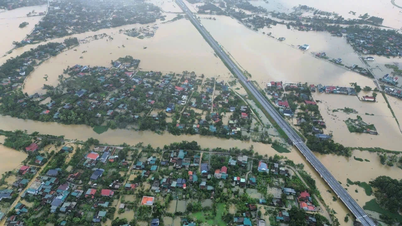
Recorded in Hai Duong city on the morning of September 11, the water level in the riverbanks on the left and right of Thai Binh river (in the wards and communes: Viet Hoa, Cam Thuong, Binh Han, Nhi Chau, Ngoc Chau, Hai Tan, Ngoc Son, An Thuong, Nam Dong, Tien Tien) was flooded and rising.
The water level of Thai Binh River is 2-2.5m above the average level; about 1.3-1.5m from the dike surface. The flood level in the riverbank area of Huu Lai Vu (Ai Quoc ward) has been flooded and is rising. The water level at Au Thuyen sluice is 3.8m, about 1m different from Sat River.
Hai Duong requested to postpone unnecessary meetings. The Chairman of the District People's Committee, heads of relevant departments, agencies, and units are responsible to the Chairman of the Provincial People's Committee if they are subjective, negligent in leadership, direction, and slow in responding to floods, leading to untimely detected construction incidents, causing serious incidents, causing great loss of life and property.
Currently, Hai Duong has deployed forces, strictly patrolled and guarded the dykes and is on duty to prevent floods according to the warning level. Identify specific areas where households living outside the riverbank are unsafe (including inside the dykes) to immediately implement plans to evacuate people and property.
All vehicles are prohibited from traveling on the dike during flood warnings, except for those authorized to travel on the dike. Ferry operations are prohibited.
At present, the dike system of Hai Duong city is safe, with no incidents. Hai Duong city currently manages 3 dike routes with a total length of 31,786 km. Of which, the Thai Binh right dike route is 15,234 km long, the Thai Binh left dike route is 15,215 km long and the Lai Vu right dike route is 1,337 km long.
![[Photo] General Secretary To Lam receives US Ambassador to Vietnam Marc Knapper](https://vphoto.vietnam.vn/thumb/1200x675/vietnam/resource/IMAGE/2025/9/29/c8fd0761aa184da7814aee57d87c49b3)
![[Photo] Many streets in Hanoi were flooded due to the effects of storm Bualoi](https://vphoto.vietnam.vn/thumb/1200x675/vietnam/resource/IMAGE/2025/9/29/18b658aa0fa2495c927ade4bbe0096df)
![[Photo] General Secretary To Lam attends the ceremony to celebrate the 80th anniversary of the post and telecommunications sector and the 66th anniversary of the science and technology sector.](https://vphoto.vietnam.vn/thumb/1200x675/vietnam/resource/IMAGE/2025/9/29/8e86b39b8fe44121a2b14a031f4cef46)
![[Photo] General Secretary To Lam, Secretary of the Central Military Commission attends the 12th Party Congress of the Army](https://vphoto.vietnam.vn/thumb/1200x675/vietnam/resource/IMAGE/2025/9/30/9b63aaa37ddb472ead84e3870a8ae825)


![[Photo] National Assembly Chairman Tran Thanh Man chairs the 8th Conference of full-time National Assembly deputies](https://vphoto.vietnam.vn/thumb/1200x675/vietnam/resource/IMAGE/2025/9/29/2c21459bc38d44ffaacd679ab9a0477c)


Comment (0)