Access to the standard Gia Dinh Map after more than 200 years of wandering
Báo Tuổi Trẻ•28/09/2024
The map of "Gia Dinh province" compiled by Tran Van Hoc in 1815 (TVH map) has been very well known. However, the copies in circulation up to now have been incomplete versions, until very recently. The Han Nom place names recorded on the maps of this version have a maximum of only 32 places, and many errors. A few years ago, fortunately, the Ho Chi Minh City Museum collected from private sources a map of the same name, the content of which far exceeds the known versions. I believe that this map is nine-tenths the Gia Dinh map made by Tran Van Hoc, possibly the original, so the academic community can use it as a standard in future research.
Before the map of Ho Chi Minh City Museum appeared, the map of Gia Dinh province basically had several versions as follows:
Although it did not appear early, it was widely popularized as a mixed map of Vietnamese place names, printed in the Cultural Geography of Ho Chi Minh City, Volume 1 - History (1987, p.229).
Temporarily call this the 1987 Mixed Map because the place names recorded on it were not translated from the original TVH map into Han Nom, but collected from Truong Vinh Ky and many other sources, with many administrative place names that are not consistent. The 1987 Mixed Map can therefore only help to understand the general information about place names and locations in the Saigon area during the Minh Mang period, but does not represent Tran Van Hoc's point of view, and cannot be a reliable reference source about the context of Saigon in 1815, so it is difficult to cite if going deep into the field of cartography.
Early on in the research, we can cite the case of Louis Malleret, through his works Elements d'une Monographie des anciennes fortifications et Citadelles de Saigon (Bulletin de la Societe des Etudes Indochinoises, no. 4, 10-11/1935); and Les Anciennes Fortifications et Citadelles de Saigon (1674-1859) (The ancient citadels and fortifications in Saigon 1674-1859, Nguyen Van Cua Publishing House, Saigon, 1936).
Map of “Gia Dinh province” by L. Malleret (1935 & 1936). Photo: PHQ Documents
This map has Han-Nom place names, without a postmark (in Han characters), it is unclear where he based the notes (in French) on the time of drawing. The map also correctly records the author's name Tran Van Hoc, and the time of drawing was December 4, Gia Long 14 (1815), the notes do not record the map's size. This is a copied map (temporarily called Version 1), the eastern part (Saigon River, and the east bank of the river) has been cut off; many places and locations in the North (Ba Da Loc tomb, Due Tong tomb, Hanh Thong commune, Ben Cat market...) and the West (Binh Hung mound, Rach Lao) are not recorded, this is also the common situation of all versions. In addition to being lost due to the map being cut off, the remaining part is also missing a lot, only 32 places remain (1/3 compared to the Ho Chi Minh City Museum version). The Nom place names are also written incorrectly and missing many places. For example, the place names Go Bau Tron and Go Tan Dinh, with the word Go (ࡍ?) written in the wrong form (the radical Tho is wrongly replaced by the radical Ngoc, many versions have the same error). On both sides of the location "Truong Sung" are missing 2 locations with notes "Mo gun dai cannon" and "Mo gun mortar" (all versions do not show and note these 2 locations), this omission greatly affects the systematicity in describing the defensive or training battlefield that Tran Van Hoc noted. Rach Bang Station and Ca Tre Station on all versions only draw symbols without naming. These omissions on the map versions will certainly greatly limit the analysis of Malleret's work.
In 1962, scholar Thai Van Kiem published the monograph "Interpretation d'une carte ancienne de Saigon" in Bulletin de la Societe des Etudes Indochinoises, ns, 37, no. 4 (1962). This version, tentatively called Version 2, measures 27.3 x 38cm, and is also an incomplete copy, similar to the Malleret version.
Gia Dinh map 1815 in research by Thai Van Kiem. Photo: PhQ documents
There is a problem in that on the illustrated map, a total of 33 place names are counted (including the title "Gia Dinh province"), but the accompanying list records 36 place names (Rach Ben Chua, Rach Ben Chieu, Rach Ban do not have Nom names written on the map). The discrepancy between the illustrated map and the table of place names compared is also a question in the use of sources in Thai Van Kiem's research. The table of comparison also has some place names with incorrect typography or pronunciation, such as "Nga tat Mu Chieu" (ie Ba Chieu), which is wrongly called "Nga tat Mu Tri", because the word Chieu (沼) and the word Tri (治) have similar shapes, so they are mistakenly recognized.
More scholastically, we see Whitmore in the book History of Cartography (1994) citing images and analyzing the map of Gia Dinh province (The History of Cartography, Volume 2, Book 2, Chapter 12: Cartography in Vietnam. The University of Chicago Press, Chicago & London, 1994).
Map of Gia Dinh Whitmore, page 502, excerpt from the history of cartography - Volume 2, Book 2, chapter 12. Photo: PhQ documents
Whitmore notes the map from Thai Van Kiem (temporarily called Version 2 bis). From the perspective of cartography, Whitmore recognized that the TVH map marked a change in perception and technique. He read on it that "The major and minor roads and ramparts seem to be very accurate, and the buildings and ponds are shown by contour symbols".
This assessment was based on intuition, Whitmore noticed the reasonableness of the length of the roads in general, or the use of geometric symbols to represent houses and streets (unlike previous maps that often used conventional and pictographic symbols). If Whitmore had surveyed the correct standard version, he would have appreciated the TVH map even more, perhaps the first Vietnamese map to apply a scale according to Western cartographic standards. In short, the above versions, used in research from 1935 to 1994, were all incomplete versions that had been widely disseminated.
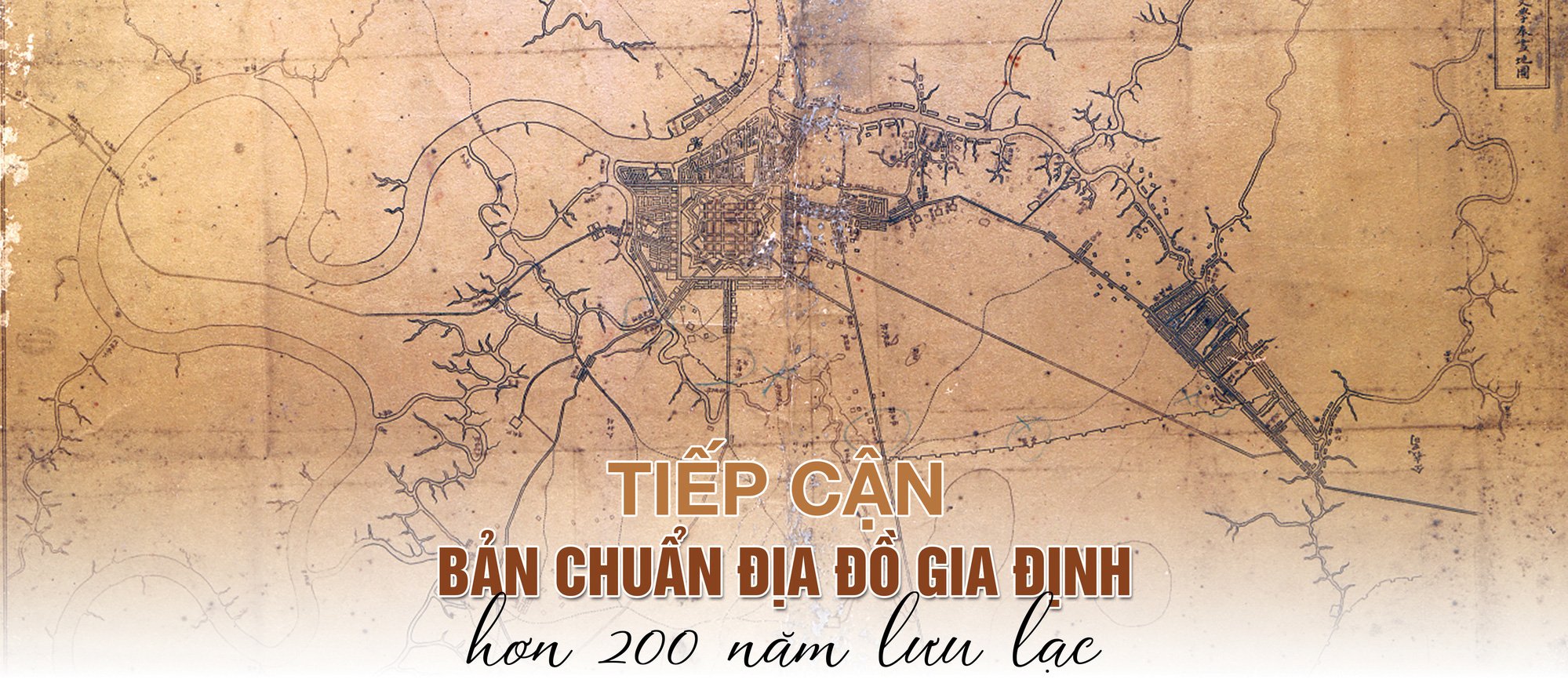
The map is currently kept at the Ho Chi Minh City Museum. The title reads "Gia Dinh Province", and the inscription: "Gia Dinh Province, Gia Long 14th year, 12th month, first 4th day, Chanh Giam Thanh, respectfully prepares and draws the map. On the 4th day of the 12th month of the 14th year of Gia Long (1815)". Among the versions circulated in the academic world until now, only this version has a special inscription, with the time of preparation and the name of the author. The map measures 50 x 31.5cm, north to south, with place names in Han-Nom characters, on paper. It is believed to be the original.
It is possible that the three words "Gia Dinh province" were added by the staff at the history office after 1832, when Gia Dinh province was established. It is worth noting that, on this standard version, the title and postmark are written 180 degrees in reverse compared to the place name system, meaning that to read the place name, the map must be turned upside down. Another reason, to understand why Tran Van Hoc could not be the one to write the three words "Gia Dinh town" or "Gia Dinh province" on the map is that he followed "Western education" at that time, and certainly understood the area shown on the map. With this scope, it can be roughly understood today as "the map of Gia Dinh city and its vicinity", but it cannot be the map of the entire province or town of Gia Dinh. The TVH map has more than 80 place names and locations, adding a lot of information, which can provide a lot of good data in research in many fields. Personally, I was very surprised because I used to think that JL Taberd was the first person to record the location of Holăng (Lang Cha Ca), but now I know that Tran Van Hoc clearly drew the mausoleum grounds and noted "Thieu pho quan lang", next to it is the larger mausoleum of Due Tong (Cuu Thuong Hoang lang), in the north of Hanh Thong commune (the map only notes "Hanh Thong"). Another example: Previously, when researching the North-South route, I consulted many sources to know about Binh Quoi road, now I see this map clearly draws the road, and notes all the locations of 3 places "Do Dong Chay", "Rach Dong Chay" and "Dong Chay Quan". Or very interesting is the name "Nga Tat Lo Giay", a completely lost canal name that has not been mentioned in any land register or historical records, corresponding to the section of Ben Cat - Vam Thuat river flowing through Bang Ky bridge. From that, it can be inferred that 200 years ago this place had a famous paper-making village that became a place name of the canal. Regarding the history of the formation of urban areas, this map records the name "Thu Thiem market" right on the east bank of the Saigon River (opposite the corner of Ton Duc Thang Street), this market is located between two small canals, with geometric symbols representing many residential areas along the large river bank to the south; and Ben Cat market (now around the end of Nguyen Thai Son Street, near Mieu Noi ferry) with symbols of symmetrical townhouses, consecutive and scattered on both sides of the canal.
The geography, environment and landscape through the TVH map are very vivid with the complete representation of the Saigon River embracing the east of Gia Dinh citadel. At the time Tran Van Hoc drew the map, on the other side of Dong Chay ferry (Binh Quoi) was the area of Bien Hoa town. The overall description of the administrative and military aspects of the central area of Gia Dinh town could not lack the traffic element, that is, the main road to the north, so the Saigon River and Thanh Da peninsula were an inseparable part. Strangely, the versions cut out that space. This cutting, jokingly speaking, the people who made the version only wanted to save a piece of paper and distorted the very complete generalization of Tran Van Hoc. Anyone who has looked at many maps made by the French reconnaissance and military during the period of spying and attacking Gia Dinh citadel (1858-1861) will see that, in terms of geographical status, many of the maps they drew were based on the TVH map, the only difference being the addition of many details about military locations, and the omission of many natural elements and objects showing economic forms. With military purposes, closely related to transportation, the Gia Dinh maps as described by the French military always fully show the river hugging the Thanh Da peninsula, with the road to Bien Hoa. With this standard TVH map, we can clearly see the vestiges of one of the most important maps in the history of the formation of a beautiful city, applying and exploiting it for new things and correcting shortcomings or mistakes in research over the past 200 years.
(*) The author would like to thank Dr. Luong Chanh Tong, Dr. Nguyen Thi Hau and Ho Chi Minh City Museum for sharing a high-quality copy of the standard TVH map to write this article.

 The map of "Gia Dinh province" compiled by Tran Van Hoc in 1815 (TVH map) has been very well known. However, the copies in circulation up to now have been incomplete versions, until very recently. The Han Nom place names recorded on the maps of this version have a maximum of only 32 places, and many errors. A few years ago, fortunately, the Ho Chi Minh City Museum collected from private sources a map of the same name, the content of which far exceeds the known versions. I believe that this map is nine-tenths the Gia Dinh map made by Tran Van Hoc, possibly the original, so the academic community can use it as a standard in future research.


![[Photo] Binh Trieu 1 Bridge has been completed, raised by 1.1m, and will open to traffic at the end of November.](https://vphoto.vietnam.vn/thumb/1200x675/vietnam/resource/IMAGE/2025/10/2/a6549e2a3b5848a1ba76a1ded6141fae)


Comment (0)