
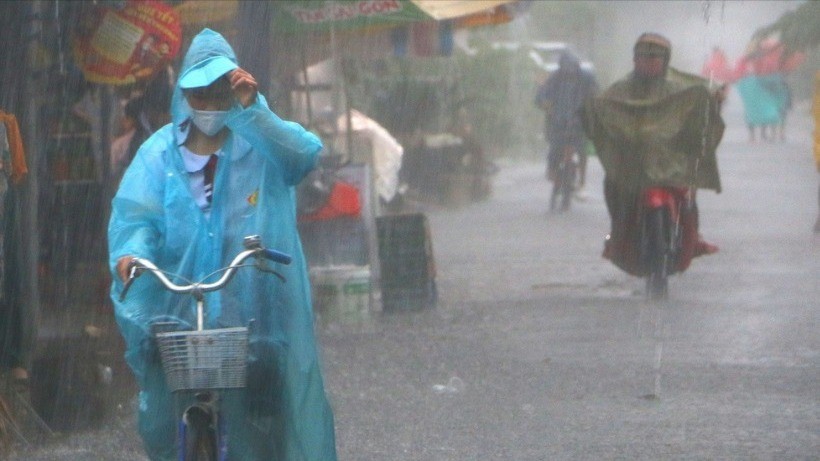
According to the National Center for Hydro-Meteorological Forecasting, from early morning to the night of September 16, in the mountainous, plain and coastal areas of the North, Thanh Hoa and Nghe An, there will be scattered showers and thunderstorms with rainfall of 10 - 30mm, locally heavy rain over 60mm (rain time coincides in the morning and night).
On the afternoon and night of September 16, the area from Da Nang to Lam Dong and the South will have scattered showers and thunderstorms with rainfall ranging from 15 - 30mm, with some places experiencing heavy rain over 80mm. Warning of the risk of heavy rain (over 80mm/3 hours). During thunderstorms, there is a possibility of tornadoes, lightning, hail and strong gusts of wind.
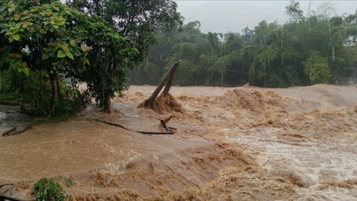
Localized heavy rain is likely to cause flash floods on small rivers and streams, landslides on steep slopes and inundation in low-lying areas.
Last night and early this morning (September 16), in the mountainous areas of the North, Nghe An, the Central Highlands and the South, there was heavy to very heavy rain. The rainfall from 7:00 p.m. on September 15 to 3:00 a.m. on September 16 was over 80mm in some places, such as: Nam Dan station (Tuyen Quang) 198mm, Ta Cu Ty station (Lao Cai) 105mm, Tan Thanh station (Lam Dong) 95.4mm, Cu Kbang station ( Dak Lak ) 83.8mm...
Low pressure moving in West Northwest direction
At 1:00 a.m. on September 16, the center of the low pressure area was at about 12.5-13.5 degrees North latitude; 115.5-116.5 degrees East longitude, in the central East Sea.
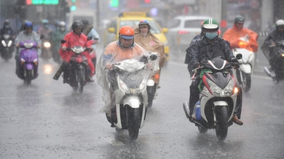
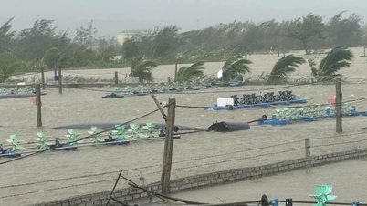
Forecast, on the day and night of September 16, the North, Central and South East Sea (including Hoang Sa and Truong Sa special zones), the Gulf of Tonkin, the sea area from South Quang Tri to Ca Mau, Ca Mau to An Giang and the Gulf of Thailand will have scattered showers and thunderstorms. During thunderstorms, there is a possibility of tornadoes, strong gusts of wind of level 6-7, waves over 2m high. The central East Sea area will have winds gradually increasing to level 5, sometimes level 6, gusts of level 8; waves 2-3m high; rough seas.
It is forecasted that in the next 24 hours, the low pressure area will move in the West Northwest direction, about 15 km per hour and is likely to strengthen into a tropical depression.

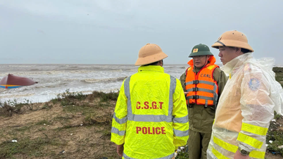
All vessels operating in the above areas are at risk of being affected by tornadoes and strong gusts of wind, and special attention should be paid to ensuring safety. Fishermen, captains and marine operators should regularly monitor forecasts and proactively take precautions when there is dangerous weather.
Specific weather in each region
The Northwestern region is cloudy, sunny during the day, with scattered showers and thunderstorms. During thunderstorms, there is a possibility of tornadoes, lightning, hail and strong gusts of wind. The lowest temperature is 23-26 degrees Celsius, with some places below 22 degrees Celsius; the highest is 31-34 degrees Celsius, with some places above 34 degrees Celsius.
Northeast
- Cloudy, sunny during the day, scattered showers and thunderstorms at night. In the plains, coastal areas and Tuyen Quang, scattered showers and thunderstorms in the morning and at night, locally heavy rain. Southeast wind level 2-3. During thunderstorms, there is a possibility of tornadoes, lightning, hail and strong gusts of wind.
- Lowest temperature from 24-27 degrees Celsius, in mountainous areas below 24 degrees Celsius; highest from 31-34 degrees Celsius, in some places above 34 degrees Celsius.
Area from Thanh Hoa to Hue
- There will be scattered showers and thunderstorms in some places. Thanh Hoa and Nghe An will have scattered showers and thunderstorms, with some heavy rain in some places. Thunderstorms may include tornadoes, lightning, hail and strong gusts of wind.
- Lowest temperature from 24-27 degrees Celsius, highest from 31-34 degrees Celsius, some places above 34 degrees Celsius.
South Central Coast
- Scattered showers and thunderstorms. Scattered showers and thunderstorms in the afternoon and evening, with some heavy rain in some places. Light wind in the North; West to Southwest wind level 2-3 in the South. Thunderstorms may cause tornadoes, lightning, hail and strong gusts of wind.
- Lowest temperature from 24-27 degrees Celsius, highest from 31-34 degrees Celsius, some places above 34 degrees Celsius.
Central Highlands region
- Scattered showers and thunderstorms. Scattered showers and thunderstorms in the afternoon and evening, with some heavy rain in some places. Southwest wind level 2-3. Thunderstorms may cause tornadoes, lightning, hail and strong gusts of wind.
- Lowest temperature from 20-23 degrees Celsius, highest from 28-31 degrees Celsius.
Southern Vietnam
- Cloudy with scattered showers and thunderstorms. Scattered showers and thunderstorms in the afternoon and evening, with some heavy rain in some places. Southwest wind level 2-3. Thunderstorms may cause tornadoes, lightning, hail and strong gusts of wind.
- Lowest temperature from 23-26 degrees Celsius, highest from 30-33 degrees Celsius, some places above 33 degrees Celsius.
Hanoi
- There will be showers and thunderstorms in the morning and at night; there will be intermittent sunshine during the day. Southeast wind level 2-3. During thunderstorms, there is a possibility of tornadoes, lightning and strong gusts of wind.
- Lowest temperature from 26-28 degrees Celsius, highest from 33-35 degrees Celsius.
Ho Chi Minh City
- Sunny during the day, occasional showers and thunderstorms in the afternoon and evening; no rain at night. Southwest wind level 2-3. During thunderstorms, there is a possibility of tornadoes, lightning, hail and strong gusts of wind.
- Lowest temperature from 25-27 degrees Celsius, highest from 32-34 degrees Celsius.
Source: https://baolaocai.vn/xuat-hien-ap-thap-tren-bien-dong-canh-bao-mua-dong-dien-rong-ngay-169-post882190.html

![[Photo] General Secretary To Lam chairs the meeting of the Central Steering Committee on preventing and combating corruption, waste and negativity](https://vphoto.vietnam.vn/thumb/1200x675/vietnam/resource/IMAGE/2025/9/29/fb2a8712315d4213a16322588c57b975)
![[Photo] General Secretary To Lam receives US Ambassador to Vietnam Marc Knapper](https://vphoto.vietnam.vn/thumb/1200x675/vietnam/resource/IMAGE/2025/9/29/c8fd0761aa184da7814aee57d87c49b3)
![[Photo] National Assembly Chairman Tran Thanh Man chairs the 8th Conference of full-time National Assembly deputies](https://vphoto.vietnam.vn/thumb/1200x675/vietnam/resource/IMAGE/2025/9/29/2c21459bc38d44ffaacd679ab9a0477c)
![[Photo] General Secretary To Lam attends the ceremony to celebrate the 80th anniversary of the post and telecommunications sector and the 66th anniversary of the science and technology sector.](https://vphoto.vietnam.vn/thumb/1200x675/vietnam/resource/IMAGE/2025/9/29/8e86b39b8fe44121a2b14a031f4cef46)
![[Photo] Many streets in Hanoi were flooded due to the effects of storm Bualoi](https://vphoto.vietnam.vn/thumb/1200x675/vietnam/resource/IMAGE/2025/9/29/18b658aa0fa2495c927ade4bbe0096df)


Comment (0)