
This afternoon, November 8, the Ministry of Agriculture and Rural Development held an online meeting with localities on response to storm No. 7.
At the meeting, Mr. Mai Van Khiem - Director of the National Center for Hydro-Meteorological Forecasting said that this morning, when storm Yinxing just entered the East Sea, the storm structure broke down. Since noon of the same day, the convective cloud system around the storm's center has improved.
According to Mr. Khiem, through observation and calculation, storm No. 7 has a tendency to become stronger again compared to the time when the storm just passed through the Luzon peninsula. From this afternoon to tonight, the storm may continue to strengthen.

Mr. Mai Van Khiem, Director of the National Center for Hydro-Meteorological Forecasting.
According to the forecast, at 7:00 p.m. on November 8, the center of storm No. 7 is located in the eastern sea of the North East Sea. The strongest wind near the center of the storm is level 14 (150-166 km/h), gusting to level 17, the storm is moving west at a speed of about 15 km/h.
Further analyzing the storm currently "swarming" the East Sea, the Director of the National Center for Hydro-Meteorological Forecasting said that in the forecast sessions from November 6 until now, the models and forecast systems in the world are still scattered and not unified.
The combination of 51 calculation options according to the European model shows that only 1-2 options predict the storm will pass through Hainan Island, the rest predict that after passing the north of Hoang Sa archipelago, the storm will head towards the Central Coast.
According to Japan's forecast, this is the strongest time of the storm, then the storm will gradually weaken, especially when it reaches the central sea area.
Regarding the forecast of the National Center for Hydro-Meteorological Forecasting, according to Mr. Khiem, when analyzing factors such as the impact of dry cold air and cold sea surface, the storm's intensity is likely to weaken. The storm's strongest intensity will only be from now until it enters the North of the Hoang Sa archipelago.
Experts also predict that this storm may weaken when it reaches the central sea. The weakened storm is affected by cold, dry air, so the possibility of circulation causing extreme heavy rain is unlikely.
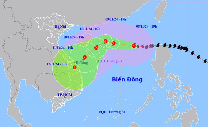
Forecast of the path and affected area of storm No. 7 at 7:00 p.m. on November 8. (Source: NCHMF)
Regarding the direction of movement, due to the influence of the subtropical high environmental current above, the impact of cold air, the national meteorological forecasting agency believes that the storm is unlikely to move north. It is highly likely that when it reaches the north of the Hoang Sa archipelago, the storm will tend to shift to the southwest, towards the Central Central Coast.
Specifically, according to the meteorological agency, at around 7pm on November 9, the storm was in the North East Sea, about 390km northeast of the Hoang Sa archipelago, moving in a West Northwest direction at a speed of about 15km/h. The strongest wind near the storm's center was level 13-14, gusting to level 17.
It is forecasted that by 7 p.m. on November 10, storm No. 7 will be about 230 km north of Hoang Sa archipelago, moving in a West-Northwest direction, then may change direction to move southwest, traveling about 10-15 km per hour, gradually weakening. The strongest wind near the storm center is level 12-13, gusting to level 16.
At 7 p.m. on November 11, the storm was about 190 kilometers west of the Paracel Islands, moving southwest at 10 kilometers per hour, weakening further. The strongest wind near the storm's center was level 8, gusting to level 11.
From the next 72 to 96 hours, the storm will move in a southwest direction, about 10km per hour, and continue to weaken.
Impact of storm No. 7, North East Sea area strong wind level 8-11, near the storm center level 12-14, gust level 17, waves 4-6m high, near the center 6-8m, rough sea.
In addition, the leader of the National Center for Hydro-Meteorological Forecasting said that through satellite analysis, there is currently a tropical convergence zone with a lot of disturbances. Therefore, it is not excluded that disturbances in the far distance in the Philippine sea area can form a tropical depression.
These disturbances will continue for the next 10 days. In addition to storm number 7, we may have to worry about the next storms soon after.
Source: https://vtcnews.vn/yinxing-co-the-suy-yeu-khi-vao-den-vung-bien-mien-trung-ar906355.html


Comment (0)