

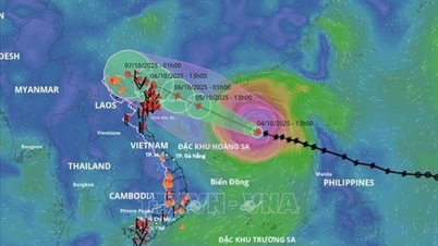
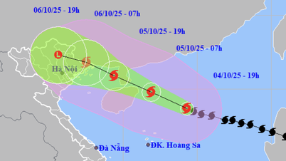
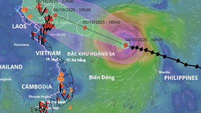
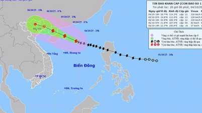
At 4:00 p.m. on October 4, the center of the storm was at about 18.5 degrees North latitude; 114.8 degrees East longitude, in the North East Sea, about 440 km East Southeast of Hainan Island (China). The strongest wind near the center of the storm was level 12 (118-133 km/h), gusting to level 15. The storm moved in a West Northwest direction at a speed of about 25 km/h.
Forecast until 4pm on October 5, the storm is moving in the West Northwest direction at a speed of 20-25km/h and is likely to strengthen. The center of the storm is located in the West of Leizhou Peninsula (China), about 250km southeast of Quang Ninh . The storm intensity is level 12, gusting to level 15. The natural disaster risk level is level 3, the affected area is the North East Sea.
At 4:00 a.m. on October 6, the storm continued to move in the West-Northwest direction at a speed of about 20km/h, entering the northern area of the Gulf of Tonkin and gradually weakening. The storm intensity is level 9, gusting to level 12. The natural disaster risk level is level 3, affecting the northwestern sea area of the North East Sea, the northern sea area of the Gulf of Tonkin and the coastal mainland area from Quang Ninh to Hung Yen .
By 4 p.m. on October 6, the storm was moving west-northwest at a speed of about 20 km/h, entering the mainland and gradually weakening in the northern mountainous region of the North. The storm intensity was level 6, gusting to level 8. The natural disaster risk level was level 3, affecting the northern sea area of the Gulf of Tonkin and the coastal mainland from Quang Ninh to Hung Yen.
At 4:00 a.m. on October 7, the storm continued to move west-northwest at a speed of 15-20 km/h, entering the western mountainous region of the North. At this time, the wind intensity decreased to below level 6.
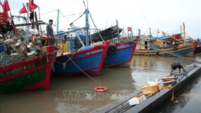
Due to the influence of the storm, at sea, the North East Sea area has strong winds of level 8-10, the area near the eye of the storm has strong winds of level 11-13, gusting to level 16; waves are 4-6m high, the area near the eye of the storm is 6-8m high; the sea is very rough, the destructive power is extremely large, can sink even large tonnage ships.
On the night of October 4 and 5, there will be storms in the North East Sea (including Hoang Sa special zone); in the Gulf of Tonkin, the Central and South East Sea (including Truong Sa special zone), the sea from the south of Quang Tri to Hue city and from Ca Mau to An Giang and the Gulf of Thailand, there will be scattered showers and thunderstorms; in the East Sea of the North Gulf of Tonkin, there will be storms from tomorrow afternoon. During the thunderstorms, there is a possibility of tornadoes, strong gusts of wind of level 6-7 and waves over 2m high.
From the afternoon of October 5, the sea area east of the northern Gulf of Tonkin (including Bach Long Vi special zone) has winds gradually increasing to level 6-7, then increasing to level 8-9. From the evening of October 5, the northern Gulf of Tonkin area (including Bach Long Vi, Van Don, Co To, Cat Hai and Hon Dau island) has winds gradually increasing to level 8-9, waves 2-4m high; the area near the storm center has strong winds of level 10-11, gusts of level 14, waves 3-5m high; the sea is very rough, very dangerous for ships.
Coastal areas and islands in Quang Ninh - Hai Phong provinces have storm surges of 0.4-0.6m. Beware of flooding in low-lying coastal areas and river mouths from the afternoon and evening of October 5.
The National Center for Hydro-Meteorological Forecasting warns that the weather at sea and in coastal areas during the storm is extremely dangerous, unsafe for any vehicle or structure operating in the danger zone, including cruise ships, passenger ships, transport ships, rafts, aquaculture areas, dykes and coastal routes. Vehicles are highly likely to capsize and be destroyed; there is a high risk of flooding due to strong winds, big waves and rising sea levels.
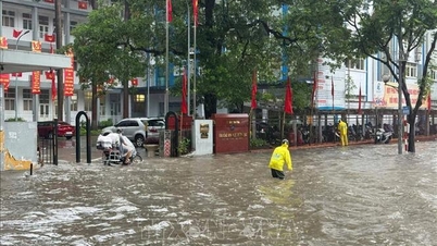
On land, from the night of October 5, coastal areas from Quang Ninh to Hung Yen will see winds gradually increasing to level 6-7, and near the storm's eye, winds will reach level 8-9, gusting to level 10-11. Winds can break tree branches, blow off roofs, and cause damage to buildings and houses. Inland areas in the Northeast will see strong winds of level 4-5, in some places level 6, gusting to level 7-8.
In addition, from the night of October 5 to the end of the night of October 7, the mountainous and midland areas of the North will have heavy rain, with rainfall ranging from 150-250mm, and locally over 400mm. There is a risk of heavy rain with an intensity of over 150mm in 3 hours.
The Northern Delta and Thanh Hoa regions have moderate to heavy rain with common rainfall of 70-150mm, locally over 200mm.
The Hanoi area is unlikely to be directly affected by the storm. However, it is forecasted that from early morning on October 6 to the end of October 7, there will be moderate to heavy rain, with average rainfall of 70-120mm, and locally over 150mm.
On the afternoon and evening of October 4, in the area from Da Nang to Lam Dong and the South, there will be scattered showers and thunderstorms with rainfall of 10-30mm, with some places experiencing heavy rain of over 80mm. Warning of the risk of heavy rain (over 70mm/3 hours).
Due to the influence of the wide storm circulation, it is necessary to guard against the risk of thunderstorms, tornadoes and strong gusts of wind both before and during the storm's landfall.
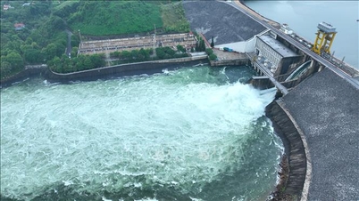
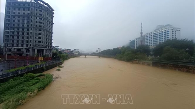
Flood warning on many rivers
Currently, floods on Cau River, Thuong River (Bac Ninh), Thai Binh River (Hai Phong) and the downstream of Ca River (Nghe An) are receding. Water levels at 1:00 p.m. on October 4 on the rivers are as follows: On Cau River at Dap Cau station 5.43m, 0.13m above alert level 2; on Thuong River at Phu Lang Thuong station 4.85m, 0.45m below alert level 2; On Thai Binh River at Pha Lai station 4.3m, 0.3m above alert level 1; on Ca River at Nam Dan station 5.88m, 0.48m above alert level 1.
In the next 12 hours, flood on Cau River will continue to decrease and be below alert level 2; in the next 12-24 hours, flood on Cau River will continue to decrease and be above alert level 1.
In the next 24 hours, floods on Thai Binh River, Thuong River and Ca River will continue to decrease and stay below alert level 1.
From October 5 to October 9, 2025, there is a possibility of a flood on rivers in the Northern region, Thanh Hoa, Nghe An, with a flood amplitude of 4-8m in the upper reaches of rivers and 2-5m in the lower reaches of rivers. During this flood, the flood peak on rivers in Quang Ninh, Lang Son, Cao Bang provinces; the flood peak on Thao River, Chay River (Lao Cai), Hoang Long River (Ninh Binh), Lo River (Tuyen Quang), Thai Binh River system (Thai Nguyen, Bac Ninh, Hai Phong) and small rivers will rise to alert level 2 - alert level 3 and above alert level 3; the flood peak at Hoa Binh Lake, Buoi River, Ma River, Chu River (Thanh Hoa) will rise to alert level 1 - alert level 2, in some places above alert level 2; Ca River will fluctuate at alert level 1 - alert level 2.
Therefore, there is a risk of flooding in low-lying areas along rivers and urban areas in the Northern region, from Thanh Hoa to Nghe An; and a risk of riverbank erosion and landslides on steep slopes in the mountainous areas of the North and from Thanh Hoa to Nghe An.
River floods inundate low-lying areas along the river, affecting activities such as waterway transport, aquaculture, agricultural production, people's lives and socio-economic activities.
Specific weather in each region on the night of October 4 and October 5
The Northwestern region has scattered showers and thunderstorms, sunny during the day. During thunderstorms, there is a possibility of tornadoes, lightning and strong gusts of wind. The lowest temperature is from 23-26 degrees Celsius, in some places below 22 degrees Celsius. The highest temperature is from 31-34 degrees Celsius.
The Northeastern region also has scattered showers and thunderstorms. From the afternoon, there will be scattered showers and thunderstorms, with some places experiencing heavy rain. The wind will be from the Northwest to the North at level 2-3. During thunderstorms, there is a possibility of tornadoes, lightning, and strong gusts of wind. The lowest temperature will be from 23-26 degrees Celsius, in mountainous areas, below 23 degrees Celsius. The highest temperature will be from 31-34 degrees Celsius.
From Thanh Hoa to Hue, the sky is cloudy with scattered showers and thunderstorms. During the day, it is sunny. West to Southwest wind level 2-3. During thunderstorms, there is a possibility of tornadoes, lightning and strong gusts of wind. The lowest temperature is from 24-27 degrees Celsius. The highest temperature is from 31-34 degrees Celsius.
The South Central Coast has scattered showers and thunderstorms, sunny during the day. Southwest wind level 2-3. During thunderstorms, there is a possibility of tornadoes, lightning and strong gusts of wind. Lowest temperature from 24-27 degrees Celsius. Highest temperature from 31-34 degrees Celsius.
The Central Highlands region has scattered showers and thunderstorms. In the late afternoon and evening, there will be scattered showers and thunderstorms, with some heavy rain in some places. Southwest wind level 2-3. During thunderstorms, there is a possibility of tornadoes, lightning and strong gusts of wind. The lowest temperature is from 19-22 degrees Celsius. The highest temperature is from 29-32 degrees Celsius.
The Southern region also has similar weather, with scattered showers and thunderstorms in some places. In the late afternoon and evening, there will be scattered showers and thunderstorms, with some places having heavy rain. Southwest wind level 2-3. During thunderstorms, there is a possibility of tornadoes, lightning and strong gusts of wind. The lowest temperature is from 24-27 degrees Celsius. The highest temperature is from 31-34 degrees Celsius.
Hanoi will be cloudy, no rain at night, sunny during the day. From tomorrow evening, there will be occasional showers and thunderstorms. Northwest to North wind level 2-3. During thunderstorms, there is a possibility of tornadoes, lightning and strong gusts of wind. Lowest temperature from 24-26 degrees Celsius. Highest temperature from 32-34 degrees Celsius.
Ho Chi Minh City, there are showers and thunderstorms in some places. In the late afternoon and evening, there are scattered showers and thunderstorms, locally heavy rain. Southwest wind level 2-3. During thunderstorms, there is a possibility of tornadoes, lightning and strong gusts of wind. Lowest temperature from 24-26 degrees Celsius. Highest temperature from 32-34 degrees Celsius.
Source: https://baotintuc.vn/van-de-quan-tam/anh-huong-bao-so-11-du-bao-ha-noi-co-mua-vua-den-mua-to-sang-610-den-het-710-20251004181646086.htm

![[Photo] Solemn opening of the 8th Congress of the Central Public Security Party Committee, term 2025-2030](https://vphoto.vietnam.vn/thumb/1200x675/vietnam/resource/IMAGE/2025/10/4/f3b00fb779f44979809441a4dac5c7df)
![[Photo] Bustling Mid-Autumn Festival at the Museum of Ethnology](https://vphoto.vietnam.vn/thumb/1200x675/vietnam/resource/IMAGE/2025/10/4/da8d5927734d4ca58e3eced14bc435a3)


![[Photo] General Secretary To Lam attends the 8th Congress of the Central Public Security Party Committee](https://vphoto.vietnam.vn/thumb/1200x675/vietnam/resource/IMAGE/2025/10/4/79fadf490f674dc483794f2d955f6045)


![[VIDEO] Summary of Petrovietnam's 50th Anniversary Ceremony](https://vphoto.vietnam.vn/thumb/402x226/vietnam/resource/IMAGE/2025/10/4/abe133bdb8114793a16d4fe3e5bd0f12)

![[VIDEO] GENERAL SECRETARY TO LAM AWARDS PETROVIETNAM 8 GOLDEN WORDS: "PIONEER - EXCELLENT - SUSTAINABLE - GLOBAL"](https://vphoto.vietnam.vn/thumb/402x226/vietnam/resource/IMAGE/2025/7/23/c2fdb48863e846cfa9fb8e6ea9cf44e7)


Comment (0)