
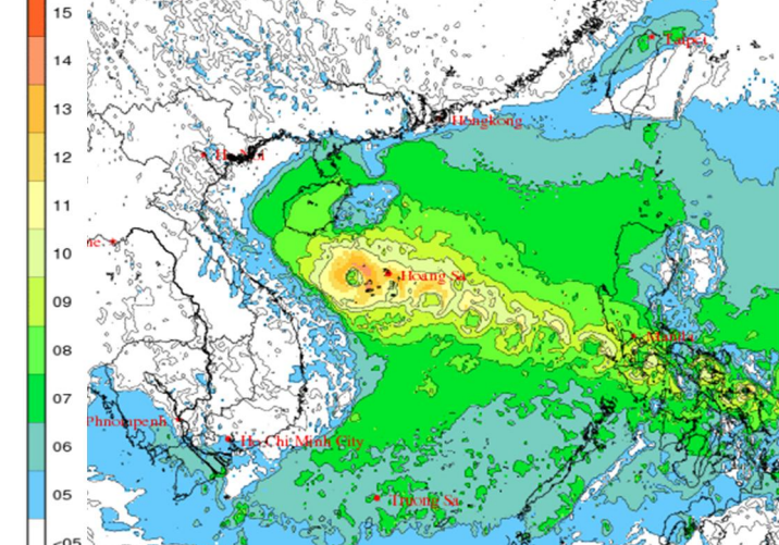
According to the National Center for Hydro-Meteorological Forecasting, at 4:00 a.m. on September 27, the center of storm Bualoi (storm No. 10) was at about 14.0 degrees North latitude; 116.6 degrees East longitude, about 580km East Southeast of Hoang Sa special zone.
The strongest wind near the storm center is level 11 - 12 (103 - 133km/h), gusting to level 15. The storm moves in the West Northwest direction at a speed of 35 - 40km/h.
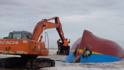
This is a very fast moving storm (nearly twice the average speed), strong intensity, wide range of influence, can cause combined impacts: strong winds, heavy rain, floods, flash floods, landslides and coastal flooding.
It is forecasted that in the next 24 - 72 hours, storm Bualoi will move in a West-Northwest direction. At 4:00 a.m. on September 28, the center of the storm will be at about 16.3 degrees North latitude; 110.0 degrees East longitude, in the sea west of Hoang Sa special zone, about 180km east of Da Nang . The storm will move in a West-Northwest direction at a speed of 30 - 35km/h, with the possibility of strengthening.
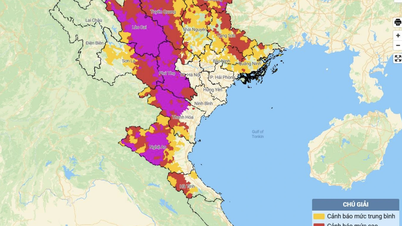
Due to the storm's influence, the northern and central East Sea (including Hoang Sa special zone) will have winds of level 8 - 9, near the storm's center level 10 - 13, gusting to level 16; waves 6.0 - 10.0m high; rough seas.
From the evening of September 27, Thanh Hoa - Quang Ngai sea area (Hon Ngu, Con Co, Ly Son): wind increased to 6 - 7, gusts 8 - 9; near the morning of September 28 increased to 8 - 9, near the storm center 10 - 13, gusts 16; waves 5.0 - 7.0m; rough sea.
From early morning of September 28, in the North of Bac Bo Gulf (Bach Long Vy, Van Don, Co To, Cat Hai, Hon Dau), the wind increased to 6 - 7, then strong 8 - 9, gust 11; wave height from 3.0 - 5.0m; very rough sea.
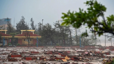
From the afternoon of September 28, Thanh Hoa - Northern Quang Tri wind 6 - 7, increasing to 8 - 9, near the storm center 10 - 12, gust 14 (dangerous, can cause trees, electric poles, houses to fall).
The sea area of Quang Ninh - Ninh Binh and South Quang Tri - Thua Thien Hue has wind 6-7, gust 8-9.
According to the Department of Dyke Management and Natural Disaster Prevention and Control, it is expected that on the evening of September 26, storm Bualoi will enter the East Sea and become storm number 10 in 2025. The storm will have a direct impact around September 29. This is a strong storm, moving very fast (twice as fast as a normal storm) and is likely to continue to increase in intensity due to few unfavorable factors on the way.
Faced with the complicated developments of the storm, on the afternoon of September 22, the Ministry of Agriculture and Environment held a meeting to deploy response solutions in the coming days.
Associate Professor - Doctor Mai Van Khiem, Director of the National Center for Hydro-Meteorological Forecasting (Department of Hydro-Meteorology, Ministry of Agriculture and Environment), said that at 1 p.m. today, the center of the storm was at about 12.6 degrees North latitude; 121.1 degrees East longitude; in the central region of the Philippines. The storm intensity is level 11, gusting over level 15. The storm moves fast at about 30km/hour.
It is forecasted that by 1 p.m. on September 27, the storm will move at about 35 km/h, enter the East Sea, and tend to strengthen. The center of the storm will be at about 15.2 degrees North latitude, 114.2 degrees East longitude, with winds of level 11-12, gusting to level 15. Disaster risk level 3 in the North and Central East Sea (including Hoang Sa special zone).
As of 1 p.m. on September 28, the National Hydrometeorological Agency forecast the storm would move at 25-30 km/hour; disaster risk level 3 in the northern and central regions of the East Sea, Hoang Sa, and the sea off Thanh Hoa-Quang Ngai.

Then, at around 1:00 p.m. on September 29, the storm continued to move at a speed of 25-30 km/hour. The risk of natural disasters due to the storm is forecast at level 3, mainly concentrated in the Northwest region and the middle of the East Sea, Hoang Sa, the Thanh Hoa-Quang Ngai sea area, and the North of the Gulf of Tonkin (including Bach Long Vy, Van Don, Co To, Cat Hai, Hon Dau).
Warning: In the next 72 - 96 hours, the storm will continue to move rapidly to the West Northwest, 25 - 30 km per hour. The storm's intensity will gradually weaken.
“With an average speed of 30km/h, this is twice as fast as other storms. In addition, the strongest intensity is level 13, gusting to level 15, when it reaches the shore it is likely to be as strong as, or even stronger than, storm number 5,” Mr. Khiem said.
According to forecasts, after hitting the East Sea tonight, September 26, there is a 70% chance that storm Bualoi will enter the North Central region. With the current forecast scenario for the storm, it is forecasted that from September 28-30, the North and provinces from Thanh Hoa to Quang Tri will have very heavy rain.
However, Mr. Khiem also noted that the occurrence of heavy rain in the above areas depends on the direction of movement on September 28-30 due to the impact of the subtropical high pressure system. In case the above forecast scenario is correct, the rain may extend to the Upper Laos region.

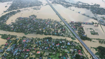
Regarding the situation of floods and landslides, with the above storm scenario, rivers in the Northern region and provinces from Thanh Hoa to Quang Tri may experience a flood, the flood peak may fluctuate at level 1-2, in some places it may fluctuate at level 3.
In response to the above developments, Mr. Pham Duc Luan - Department of Dyke Management and Natural Disaster Prevention and Control (Ministry of Agriculture and Environment) emphasized that storm Bualoi (storm No. 10) is a strong storm, moving very quickly, so the direction and response work must be carried out with a decisive spirit, early and from a distance to ensure the safety of people's lives and limit property damage.
PVSource: https://baohaiphong.vn/bao-bualoi-giat-cap-15-di-chuyen-rat-nhanh-ve-phia-dat-lien-cac-tinh-mien-trung-521871.html
![[Photo] General Secretary To Lam attends the ceremony to celebrate the 80th anniversary of the post and telecommunications sector and the 66th anniversary of the science and technology sector.](https://vphoto.vietnam.vn/thumb/1200x675/vietnam/resource/IMAGE/2025/9/29/8e86b39b8fe44121a2b14a031f4cef46)
![[Photo] General Secretary To Lam receives US Ambassador to Vietnam Marc Knapper](https://vphoto.vietnam.vn/thumb/1200x675/vietnam/resource/IMAGE/2025/9/29/c8fd0761aa184da7814aee57d87c49b3)

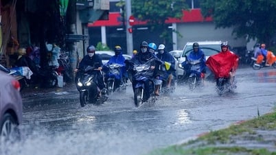
![[Photo] Many streets in Hanoi were flooded due to the effects of storm Bualoi](https://vphoto.vietnam.vn/thumb/1200x675/vietnam/resource/IMAGE/2025/9/29/18b658aa0fa2495c927ade4bbe0096df)

![[Photo] General Secretary To Lam, Secretary of the Central Military Commission attends the 12th Party Congress of the Army](https://vphoto.vietnam.vn/thumb/1200x675/vietnam/resource/IMAGE/2025/9/30/9b63aaa37ddb472ead84e3870a8ae825)


![[Photo] National Assembly Chairman Tran Thanh Man chairs the 8th Conference of full-time National Assembly deputies](https://vphoto.vietnam.vn/thumb/1200x675/vietnam/resource/IMAGE/2025/9/29/2c21459bc38d44ffaacd679ab9a0477c)


Comment (0)