
The National Center for Hydro-Meteorological Forecasting said that due to the influence of the circulation of storm Bualoi (storm No. 10), at Ly Son station (Quang Ngai) there were strong winds of level 6, gusts of level 8; Hoi An station ( Da Nang ) had strong winds of level 6, gusts of level 8; Bac Trach station (Quang Tri) had strong winds of level 6, gusts of level 8, Con Co (Quang Tri) had strong winds of level 6, gusts of level 7.
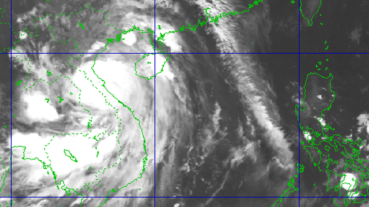
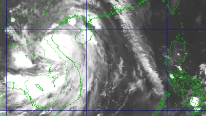
At 8:00 a.m. on September 28, a level 12 storm (118-133 km/h), gusting to level 15, was active in the Quang Tri - Da Nang sea area, about 150 km east of Hue. The storm moved west-northwest at a speed of 30 km/h.
The Hydrometeorological Agency said that this is a very fast moving storm (nearly twice the average speed), with strong storm intensity and a wide range of influence, which can cause combined impacts of many types of natural disasters such as strong winds, heavy rains, floods, flash floods, landslides and coastal flooding.
It is forecasted that this afternoon, the storm will enter the sea area of Nghe An - Quang Tri with intensity of level 12-13, gusts of level 16 and has the potential to strengthen.

At 7 p.m., the storm was active in the sea area of Nghe An - Quang Tri with intensity of level 12-13, gusting to level 16. The sea area west of the North and central East Sea (including Hoang Sa special zone) and the sea area from Thanh Hoa to Quang Ngai were affected.
According to forecasts, by the night and early morning of September 29, the storm will make landfall, operating in the western region of the provinces from Thanh Hoa - Ha Tinh with intensity of level 8, gusting to level 12. The coastal mainland area from Nghe An to the north of Quang Tri will be directly affected with a level 4 natural disaster risk level (level 5 is the highest).
Due to the influence of the storm, the western sea area of the North and Central East Sea (including Hoang Sa special zone) has strong winds of level 8-9, waves of 6-8m high, and very rough seas.
The sea area from Thanh Hoa to Quang Ngai (including Hon Ngu island, Con Co special zone and Ly Son) has strong winds of level 6-7, then increasing to level 8-9, the area near the storm center has winds of level 10-13, gusts of level 16, waves of 5-7m high, very rough seas (extremely destructive, extremely strong waves. Sinking large tonnage ships).
In the Northern Gulf of Tonkin (including Bach Long Vi, Van Don, Co To, Cat Hai and Hon Dau islands), the wind gradually increases to level 6-7, then increases to level 8-9 (very rough seas, very dangerous for boats), gusts to level 11, waves 3.0-5.0m high, very rough seas.
Coastal areas and islands from Hung Yen to Ha Tinh have storm surges of 0.5-1.5m, especially in southern Thanh Hoa and Nghe An where the water level will rise 1-1.5m. There is a high risk of flooding in low-lying areas, coastal roads, and river mouths due to storm surges and waves on the night of September 28 and the morning of September 29.
Coastal areas and islands from Ninh Binh to Ha Tinh have storm surges of 0.5-1.5m, especially from South Thanh Hoa to North Ha Tinh, the water level will rise 1-1.5m. The risk of flooding of dykes, coastal roads, and river mouths due to storm surges and waves is very high on the evening and night of September 28.
On land, the area from South Quang Tri to Da Nang has strong winds of level 6-7, gusting to level 8-9.
From noon on September 28, on the mainland from Thanh Hoa to Northern Quang Tri, the wind gradually increased to level 6-7, then increased to level 8-9, near the storm center level 10-12 (wind force can knock down trees, houses, electric poles, causing very heavy damage), gust level 14.
From the afternoon of September 28, coastal areas from Quang Ninh to Ninh Binh will have strong winds of level 6-7, gusting to level 8-9.
Regarding heavy rain, on September 28-30, the Northern region and the area from Thanh Hoa to Quang Ngai are likely to experience widespread heavy rain with total rainfall of 100-300mm, locally over 450mm.
According to the forecast, in the Northern Delta region, South Phu Tho and from Thanh Hoa to North Quang Tri, it is common to have 200-400mm, locally over 600mm. Warning of the risk of heavy rain over 200mm/3 hours.
Source dantri.vn
Source: https://baophutho.vn/bao-bualoi-manh-cap-12-da-di-vao-vung-bien-quang-tri-da-nang-240275.htm


![[Photo] Joy on the new Phong Chau bridge](https://vphoto.vietnam.vn/thumb/1200x675/vietnam/resource/IMAGE/2025/9/28/b00322b29c8043fbb8b6844fdd6c78ea)
![[Photo] High-ranking delegation of the Russian State Duma visits President Ho Chi Minh's Mausoleum](https://vphoto.vietnam.vn/thumb/1200x675/vietnam/resource/IMAGE/2025/9/28/c6dfd505d79b460a93752e48882e8f7e)
![[Photo] The 4th meeting of the Inter-Parliamentary Cooperation Committee between the National Assembly of Vietnam and the State Duma of Russia](https://vphoto.vietnam.vn/thumb/1200x675/vietnam/resource/IMAGE/2025/9/28/9f9e84a38675449aa9c08b391e153183)


Comment (0)